
Data preparation#
The neuralgcm-torch version of the upstream
data_preparation
notebook: preparing ERA5-style data for NeuralGCM and converting between
xarray.Dataset and the dict-of-tensors format used by the model API.
Needs network access for the ERA5 data (anonymous GCS).
NeuralGCM models take and produce data on ERA5’s 37 pressure levels, including the following variables, provided in SI units on the NeuralGCM model’s native grid:
Inputs/outputs (on pressure levels):
u_component_of_wind,v_component_of_wind,geopotential,temperature,specific_humidity,specific_cloud_ice_water_content,specific_cloud_liquid_water_content.Forcings (surface level only):
sea_surface_temperature,sea_ice_cover.
sim_time is the only exception, which gives time in NeuralGCM’s internal
nondimensional units.
Regridding data#
Preparing a dataset stored on a different horizontal grid for NeuralGCM requires two steps:
Horizontal regridding to a Gaussian grid. For processing fine-resolution data conservative regridding is most appropriate (and is what we used to train NeuralGCM).
Filling in all missing values (NaN), to ensure all inputs are valid. Forcing fields like
sea_surface_temperatureare only defined over ocean in ERA5, and NeuralGCM’s surface model also includes a mask that ignores values over land.
import numpy as np
import torch
import xarray

from dinosaur_torch import horizontal_interpolation
from dinosaur_torch import xarray_utils
import neuralgcm_torch as neuralgcm

device = 'cuda' if torch.cuda.is_available() else 'cpu'
from neuralgcm_torch import pretrained
# Fetched from the Hugging Face Hub on first use (cached), or reused from
# a local checkpoints/ directory if present.
converted_path = pretrained.fetch_checkpoint('tl63_stochastic_mini', local_root='checkpoints')
model = neuralgcm.PressureLevelModel.from_checkpoint(converted_path, device=device)
era5_path = 'gs://gcp-public-data-arco-era5/ar/full_37-1h-0p25deg-chunk-1.zarr-v3'
full_era5 = xarray.open_zarr(
    era5_path, chunks=None, storage_options=dict(token='anon')
)
full_era5
<xarray.Dataset> Size: 4PB
Dimensions:                                                          (
                                                                      time: 1323648,
                                                                      latitude: 721,
                                                                      longitude: 1440,
                                                                      level: 37)
Coordinates:
  * time                                                             (time) datetime64[ns] 11MB ...
  * latitude                                                         (latitude) float32 3kB ...
  * longitude                                                        (longitude) float32 6kB ...
  * level                                                            (level) int64 296B ...
Data variables: (12/273)
    100m_u_component_of_wind                                         (time, latitude, longitude) float32 5TB ...
    100m_v_component_of_wind                                         (time, latitude, longitude) float32 5TB ...
    10m_u_component_of_neutral_wind                                  (time, latitude, longitude) float32 5TB ...
    10m_u_component_of_wind                                          (time, latitude, longitude) float32 5TB ...
    10m_v_component_of_neutral_wind                                  (time, latitude, longitude) float32 5TB ...
    10m_v_component_of_wind                                          (time, latitude, longitude) float32 5TB ...
    ...                                                               ...
    wave_spectral_directional_width_for_swell                        (time, latitude, longitude) float32 5TB ...
    wave_spectral_directional_width_for_wind_waves                   (time, latitude, longitude) float32 5TB ...
    wave_spectral_kurtosis                                           (time, latitude, longitude) float32 5TB ...
    wave_spectral_peakedness                                         (time, latitude, longitude) float32 5TB ...
    wave_spectral_skewness                                           (time, latitude, longitude) float32 5TB ...
    zero_degree_level                                                (time, latitude, longitude) float32 5TB ...
Attributes:
    last_updated:           2026-06-12 02:43:37.240316+00:00
    valid_time_start:       1940-01-01
    valid_time_stop:        2025-12-31
valid_time_stop_era5t: 2026-06-06- time: 1323648
- latitude: 721
- longitude: 1440
- level: 37
- time(time)datetime64[ns]1900-01-01 ... 2050-12-31T23:00:00
array(['1900-01-01T00:00:00.000000000', '1900-01-01T01:00:00.000000000', '1900-01-01T02:00:00.000000000', ..., '2050-12-31T21:00:00.000000000', '2050-12-31T22:00:00.000000000', '2050-12-31T23:00:00.000000000'], shape=(1323648,), dtype='datetime64[ns]') - latitude(latitude)float3290.0 89.75 89.5 ... -89.75 -90.0
- long_name :
- latitude
- units :
- degrees_north
array([ 90. , 89.75, 89.5 , ..., -89.5 , -89.75, -90. ], shape=(721,), dtype=float32) - longitude(longitude)float320.0 0.25 0.5 ... 359.2 359.5 359.8
- long_name :
- longitude
- units :
- degrees_east
array([0.0000e+00, 2.5000e-01, 5.0000e-01, ..., 3.5925e+02, 3.5950e+02, 3.5975e+02], shape=(1440,), dtype=float32) - level(level)int641 2 3 5 7 ... 900 925 950 975 1000
- long_name :
- level
- units :
- Hectopascal(hPa)
array([   1,    2,    3,    5,    7,   10,   20,   30,   50,   70,  100,  125,
        150,  175,  200,  225,  250,  300,  350,  400,  450,  500,  550,  600,
        650,  700,  750,  775,  800,  825,  850,  875,  900,  925,  950,  975,
       1000])
- 100m_u_component_of_wind(time, latitude, longitude)float32...
- long_name :
- 100 metre U wind component
- short_name :
- u100
- units :
- m s**-1
[1374264299520 values with dtype=float32]
- 100m_v_component_of_wind(time, latitude, longitude)float32...
- long_name :
- 100 metre V wind component
- short_name :
- v100
- units :
- m s**-1
[1374264299520 values with dtype=float32]
- 10m_u_component_of_neutral_wind(time, latitude, longitude)float32...
- long_name :
- Neutral wind at 10 m u-component
- short_name :
- u10n
- units :
- m s**-1
[1374264299520 values with dtype=float32]
- 10m_u_component_of_wind(time, latitude, longitude)float32...
- long_name :
- 10 metre U wind component
- short_name :
- u10
- units :
- m s**-1
[1374264299520 values with dtype=float32]
- 10m_v_component_of_neutral_wind(time, latitude, longitude)float32...
- long_name :
- Neutral wind at 10 m v-component
- short_name :
- v10n
- units :
- m s**-1
[1374264299520 values with dtype=float32]
- 10m_v_component_of_wind(time, latitude, longitude)float32...
- long_name :
- 10 metre V wind component
- short_name :
- v10
- units :
- m s**-1
[1374264299520 values with dtype=float32]
- 10m_wind_gust_since_previous_post_processing(time, latitude, longitude)float32...
- long_name :
- 10 metre wind gust since previous post-processing
- short_name :
- fg10
- units :
- m s**-1
[1374264299520 values with dtype=float32]
- 2m_dewpoint_temperature(time, latitude, longitude)float32...
- long_name :
- 2 metre dewpoint temperature
- short_name :
- d2m
- units :
- K
[1374264299520 values with dtype=float32]
- 2m_temperature(time, latitude, longitude)float32...
- long_name :
- 2 metre temperature
- short_name :
- t2m
- units :
- K
[1374264299520 values with dtype=float32]
- air_density_over_the_oceans(time, latitude, longitude)float32...
- long_name :
- Air density over the oceans
- short_name :
- p140209
- units :
- kg m**-3
[1374264299520 values with dtype=float32]
- angle_of_sub_gridscale_orography(time, latitude, longitude)float32...
- long_name :
- Angle of sub-gridscale orography
- short_name :
- anor
- units :
- radians
[1374264299520 values with dtype=float32]
- anisotropy_of_sub_gridscale_orography(time, latitude, longitude)float32...
- long_name :
- Anisotropy of sub-gridscale orography
- short_name :
- isor
- units :
- ~
[1374264299520 values with dtype=float32]
- benjamin_feir_index(time, latitude, longitude)float32...
- long_name :
- Benjamin-Feir index
- short_name :
- bfi
- units :
- dimensionless
[1374264299520 values with dtype=float32]
- boundary_layer_dissipation(time, latitude, longitude)float32...
- long_name :
- Boundary layer dissipation
- short_name :
- bld
- standard_name :
- kinetic_energy_dissipation_in_atmosphere_boundary_layer
- units :
- J m**-2
[1374264299520 values with dtype=float32]
- boundary_layer_height(time, latitude, longitude)float32...
- long_name :
- Boundary layer height
- short_name :
- blh
- units :
- m
[1374264299520 values with dtype=float32]
- charnock(time, latitude, longitude)float32...
- long_name :
- Charnock
- short_name :
- chnk
- units :
- ~
[1374264299520 values with dtype=float32]
- clear_sky_direct_solar_radiation_at_surface(time, latitude, longitude)float32...
- long_name :
- Clear-sky direct solar radiation at surface
- short_name :
- cdir
- units :
- J m**-2
[1374264299520 values with dtype=float32]
- cloud_base_height(time, latitude, longitude)float32...
- long_name :
- Cloud base height
- short_name :
- cbh
- units :
- m
[1374264299520 values with dtype=float32]
- coefficient_of_drag_with_waves(time, latitude, longitude)float32...
- long_name :
- Coefficient of drag with waves
- short_name :
- cdww
- units :
- dimensionless
[1374264299520 values with dtype=float32]
- convective_available_potential_energy(time, latitude, longitude)float32...
- long_name :
- Convective available potential energy
- short_name :
- cape
- units :
- J kg**-1
[1374264299520 values with dtype=float32]
- convective_inhibition(time, latitude, longitude)float32...
- long_name :
- Convective inhibition
- short_name :
- cin
- units :
- J kg**-1
[1374264299520 values with dtype=float32]
- convective_precipitation(time, latitude, longitude)float32...
- long_name :
- Convective precipitation
- short_name :
- cp
- standard_name :
- lwe_thickness_of_convective_precipitation_amount
- units :
- m
[1374264299520 values with dtype=float32]
- convective_rain_rate(time, latitude, longitude)float32...
- long_name :
- Convective rain rate
- short_name :
- crr
- units :
- kg m**-2 s**-1
[1374264299520 values with dtype=float32]
- convective_snowfall(time, latitude, longitude)float32...
- long_name :
- Convective snowfall
- short_name :
- csf
- units :
- m of water equivalent
[1374264299520 values with dtype=float32]
- convective_snowfall_rate_water_equivalent(time, latitude, longitude)float32...
- long_name :
- Convective snowfall rate water equivalent
- short_name :
- csfr
- units :
- kg m**-2 s**-1
[1374264299520 values with dtype=float32]
- downward_uv_radiation_at_the_surface(time, latitude, longitude)float32...
- long_name :
- Downward UV radiation at the surface
- short_name :
- uvb
- units :
- J m**-2
[1374264299520 values with dtype=float32]
- duct_base_height(time, latitude, longitude)float32...
- long_name :
- Duct base height
- short_name :
- dctb
- units :
- m
[1374264299520 values with dtype=float32]
- eastward_gravity_wave_surface_stress(time, latitude, longitude)float32...
- long_name :
- Eastward gravity wave surface stress
- short_name :
- lgws
- units :
- N m**-2 s
[1374264299520 values with dtype=float32]
- eastward_turbulent_surface_stress(time, latitude, longitude)float32...
- long_name :
- Eastward turbulent surface stress
- short_name :
- ewss
- standard_name :
- surface_downward_eastward_stress
- units :
- N m**-2 s
[1374264299520 values with dtype=float32]
- evaporation(time, latitude, longitude)float32...
- long_name :
- Evaporation
- short_name :
- e
- standard_name :
- lwe_thickness_of_water_evaporation_amount
- units :
- m of water equivalent
[1374264299520 values with dtype=float32]
- forecast_albedo(time, latitude, longitude)float32...
- long_name :
- Forecast albedo
- short_name :
- fal
- units :
- (0 - 1)
[1374264299520 values with dtype=float32]
- forecast_logarithm_of_surface_roughness_for_heat(time, latitude, longitude)float32...
- long_name :
- Forecast logarithm of surface roughness for heat
- short_name :
- flsr
- units :
- ~
[1374264299520 values with dtype=float32]
- forecast_surface_roughness(time, latitude, longitude)float32...
- long_name :
- Forecast surface roughness
- short_name :
- fsr
- units :
- m
[1374264299520 values with dtype=float32]
- fraction_of_cloud_cover(time, level, latitude, longitude)float32...
- long_name :
- Fraction of cloud cover
- short_name :
- cc
- units :
- (0 - 1)
[50847779082240 values with dtype=float32]
- free_convective_velocity_over_the_oceans(time, latitude, longitude)float32...
- long_name :
- Free convective velocity over the oceans
- short_name :
- p140208
- units :
- m s**-1
[1374264299520 values with dtype=float32]
- friction_velocity(time, latitude, longitude)float32...
- long_name :
- Friction velocity
- short_name :
- zust
- units :
- m s**-1
[1374264299520 values with dtype=float32]
- geopotential(time, level, latitude, longitude)float32...
- long_name :
- Geopotential
- short_name :
- z
- standard_name :
- geopotential
- units :
- m**2 s**-2
[50847779082240 values with dtype=float32]
- geopotential_at_surface(time, latitude, longitude)float32...
- long_name :
- Geopotential
- short_name :
- z
- standard_name :
- geopotential
- units :
- m**2 s**-2
[1374264299520 values with dtype=float32]
- gravity_wave_dissipation(time, latitude, longitude)float32...
- long_name :
- Gravity wave dissipation
- short_name :
- gwd
- units :
- J m**-2
[1374264299520 values with dtype=float32]
- high_cloud_cover(time, latitude, longitude)float32...
- long_name :
- High cloud cover
- short_name :
- hcc
- units :
- (0 - 1)
[1374264299520 values with dtype=float32]
- high_vegetation_cover(time, latitude, longitude)float32...
- long_name :
- High vegetation cover
- short_name :
- cvh
- units :
- (0 - 1)
[1374264299520 values with dtype=float32]
- ice_temperature_layer_1(time, latitude, longitude)float32...
- long_name :
- Ice temperature layer 1
- short_name :
- istl1
- units :
- K
[1374264299520 values with dtype=float32]
- ice_temperature_layer_2(time, latitude, longitude)float32...
- long_name :
- Ice temperature layer 2
- short_name :
- istl2
- units :
- K
[1374264299520 values with dtype=float32]
- ice_temperature_layer_3(time, latitude, longitude)float32...
- long_name :
- Ice temperature layer 3
- short_name :
- istl3
- units :
- K
[1374264299520 values with dtype=float32]
- ice_temperature_layer_4(time, latitude, longitude)float32...
- long_name :
- Ice temperature layer 4
- short_name :
- istl4
- units :
- K
[1374264299520 values with dtype=float32]
- instantaneous_10m_wind_gust(time, latitude, longitude)float32...
- long_name :
- Instantaneous 10 metre wind gust
- short_name :
- i10fg
- units :
- m s**-1
[1374264299520 values with dtype=float32]
- instantaneous_eastward_turbulent_surface_stress(time, latitude, longitude)float32...
- long_name :
- Instantaneous eastward turbulent surface stress
- short_name :
- iews
- units :
- N m**-2
[1374264299520 values with dtype=float32]
- instantaneous_large_scale_surface_precipitation_fraction(time, latitude, longitude)float32...
- long_name :
- Instantaneous large-scale surface precipitation fraction
- short_name :
- ilspf
- units :
- (0 - 1)
[1374264299520 values with dtype=float32]
- instantaneous_moisture_flux(time, latitude, longitude)float32...
- long_name :
- Instantaneous moisture flux
- short_name :
- ie
- units :
- kg m**-2 s**-1
[1374264299520 values with dtype=float32]
- instantaneous_northward_turbulent_surface_stress(time, latitude, longitude)float32...
- long_name :
- Instantaneous northward turbulent surface stress
- short_name :
- inss
- units :
- N m**-2
[1374264299520 values with dtype=float32]
- instantaneous_surface_sensible_heat_flux(time, latitude, longitude)float32...
- long_name :
- Instantaneous surface sensible heat flux
- short_name :
- ishf
- units :
- W m**-2
[1374264299520 values with dtype=float32]
- k_index(time, latitude, longitude)float32...
- long_name :
- K index
- short_name :
- kx
- units :
- K
[1374264299520 values with dtype=float32]
- lake_bottom_temperature(time, latitude, longitude)float32...
- long_name :
- Lake bottom temperature
- short_name :
- lblt
- units :
- K
[1374264299520 values with dtype=float32]
- lake_cover(time, latitude, longitude)float32...
- long_name :
- Lake cover
- short_name :
- cl
- units :
- (0 - 1)
[1374264299520 values with dtype=float32]
- lake_depth(time, latitude, longitude)float32...
- long_name :
- Lake total depth
- short_name :
- dl
- units :
- m
[1374264299520 values with dtype=float32]
- lake_ice_depth(time, latitude, longitude)float32...
- long_name :
- Lake ice total depth
- short_name :
- licd
- units :
- m
[1374264299520 values with dtype=float32]
- lake_ice_temperature(time, latitude, longitude)float32...
- long_name :
- Lake ice surface temperature
- short_name :
- lict
- units :
- K
[1374264299520 values with dtype=float32]
- lake_mix_layer_depth(time, latitude, longitude)float32...
- long_name :
- Lake mix-layer depth
- short_name :
- lmld
- units :
- m
[1374264299520 values with dtype=float32]
- lake_mix_layer_temperature(time, latitude, longitude)float32...
- long_name :
- Lake mix-layer temperature
- short_name :
- lmlt
- units :
- K
[1374264299520 values with dtype=float32]
- lake_shape_factor(time, latitude, longitude)float32...
- long_name :
- Lake shape factor
- short_name :
- lshf
- units :
- dimensionless
[1374264299520 values with dtype=float32]
- lake_total_layer_temperature(time, latitude, longitude)float32...
- long_name :
- Lake total layer temperature
- short_name :
- ltlt
- units :
- K
[1374264299520 values with dtype=float32]
- land_sea_mask(time, latitude, longitude)float32...
- long_name :
- Land-sea mask
- short_name :
- lsm
- standard_name :
- land_binary_mask
- units :
- (0 - 1)
[1374264299520 values with dtype=float32]
- large_scale_precipitation(time, latitude, longitude)float32...
- long_name :
- Large-scale precipitation
- short_name :
- lsp
- standard_name :
- lwe_thickness_of_stratiform_precipitation_amount
- units :
- m
[1374264299520 values with dtype=float32]
- large_scale_precipitation_fraction(time, latitude, longitude)float32...
- long_name :
- Large-scale precipitation fraction
- short_name :
- lspf
- units :
- s
[1374264299520 values with dtype=float32]
- large_scale_rain_rate(time, latitude, longitude)float32...
- long_name :
- Large scale rain rate
- short_name :
- lsrr
- units :
- kg m**-2 s**-1
[1374264299520 values with dtype=float32]
- large_scale_snowfall(time, latitude, longitude)float32...
- long_name :
- Large-scale snowfall
- short_name :
- lsf
- units :
- m of water equivalent
[1374264299520 values with dtype=float32]
- large_scale_snowfall_rate_water_equivalent(time, latitude, longitude)float32...
- long_name :
- Large scale snowfall rate water equivalent
- short_name :
- lssfr
- units :
- kg m**-2 s**-1
[1374264299520 values with dtype=float32]
- leaf_area_index_high_vegetation(time, latitude, longitude)float32...
- long_name :
- Leaf area index, high vegetation
- short_name :
- lai_hv
- units :
- m**2 m**-2
[1374264299520 values with dtype=float32]
- leaf_area_index_low_vegetation(time, latitude, longitude)float32...
- long_name :
- Leaf area index, low vegetation
- short_name :
- lai_lv
- units :
- m**2 m**-2
[1374264299520 values with dtype=float32]
- low_cloud_cover(time, latitude, longitude)float32...
- long_name :
- Low cloud cover
- short_name :
- lcc
- units :
- (0 - 1)
[1374264299520 values with dtype=float32]
- low_vegetation_cover(time, latitude, longitude)float32...
- long_name :
- Low vegetation cover
- short_name :
- cvl
- units :
- (0 - 1)
[1374264299520 values with dtype=float32]
- maximum_2m_temperature_since_previous_post_processing(time, latitude, longitude)float32...
- long_name :
- Maximum temperature at 2 metres since previous post-processing
- short_name :
- mx2t
- units :
- K
[1374264299520 values with dtype=float32]
- maximum_individual_wave_height(time, latitude, longitude)float32...
- long_name :
- Maximum individual wave height
- short_name :
- hmax
- units :
- m
[1374264299520 values with dtype=float32]
- maximum_total_precipitation_rate_since_previous_post_processing(time, latitude, longitude)float32...
- long_name :
- Maximum total precipitation rate since previous post-processing
- short_name :
- mxtpr
- units :
- kg m**-2 s**-1
[1374264299520 values with dtype=float32]
- mean_boundary_layer_dissipation(time, latitude, longitude)float32...
- long_name :
- Mean boundary layer dissipation
- short_name :
- mbld
- units :
- W m**-2
[1374264299520 values with dtype=float32]
- mean_convective_precipitation_rate(time, latitude, longitude)float32...
- long_name :
- Mean convective precipitation rate
- short_name :
- mcpr
- units :
- kg m**-2 s**-1
[1374264299520 values with dtype=float32]
- mean_convective_snowfall_rate(time, latitude, longitude)float32...
- long_name :
- Mean convective snowfall rate
- short_name :
- mcsr
- units :
- kg m**-2 s**-1
[1374264299520 values with dtype=float32]
- mean_direction_of_total_swell(time, latitude, longitude)float32...
- long_name :
- Mean direction of total swell
- short_name :
- mdts
- units :
- degrees
[1374264299520 values with dtype=float32]
- mean_direction_of_wind_waves(time, latitude, longitude)float32...
- long_name :
- Mean direction of wind waves
- short_name :
- mdww
- units :
- degrees
[1374264299520 values with dtype=float32]
- mean_eastward_gravity_wave_surface_stress(time, latitude, longitude)float32...
- long_name :
- Mean eastward gravity wave surface stress
- short_name :
- megwss
- units :
- N m**-2
[1374264299520 values with dtype=float32]
- mean_eastward_turbulent_surface_stress(time, latitude, longitude)float32...
- long_name :
- Mean eastward turbulent surface stress
- short_name :
- metss
- units :
- N m**-2
[1374264299520 values with dtype=float32]
- mean_evaporation_rate(time, latitude, longitude)float32...
- long_name :
- Mean evaporation rate
- short_name :
- mer
- units :
- kg m**-2 s**-1
[1374264299520 values with dtype=float32]
- mean_gravity_wave_dissipation(time, latitude, longitude)float32...
- long_name :
- Mean gravity wave dissipation
- short_name :
- mgwd
- units :
- W m**-2
[1374264299520 values with dtype=float32]
- mean_large_scale_precipitation_fraction(time, latitude, longitude)float32...
- long_name :
- Mean large-scale precipitation fraction
- short_name :
- mlspf
- units :
- Proportion
[1374264299520 values with dtype=float32]
- mean_large_scale_precipitation_rate(time, latitude, longitude)float32...
- long_name :
- Mean large-scale precipitation rate
- short_name :
- mlspr
- units :
- kg m**-2 s**-1
[1374264299520 values with dtype=float32]
- mean_large_scale_snowfall_rate(time, latitude, longitude)float32...
- long_name :
- Mean large-scale snowfall rate
- short_name :
- mlssr
- units :
- kg m**-2 s**-1
[1374264299520 values with dtype=float32]
- mean_northward_gravity_wave_surface_stress(time, latitude, longitude)float32...
- long_name :
- Mean northward gravity wave surface stress
- short_name :
- mngwss
- units :
- N m**-2
[1374264299520 values with dtype=float32]
- mean_northward_turbulent_surface_stress(time, latitude, longitude)float32...
- long_name :
- Mean northward turbulent surface stress
- short_name :
- mntss
- units :
- N m**-2
[1374264299520 values with dtype=float32]
- mean_period_of_total_swell(time, latitude, longitude)float32...
- long_name :
- Mean period of total swell
- short_name :
- mpts
- units :
- s
[1374264299520 values with dtype=float32]
- mean_period_of_wind_waves(time, latitude, longitude)float32...
- long_name :
- Mean period of wind waves
- short_name :
- mpww
- units :
- s
[1374264299520 values with dtype=float32]
- mean_potential_evaporation_rate(time, latitude, longitude)float32...
- long_name :
- Mean potential evaporation rate
- short_name :
- mper
- units :
- kg m**-2 s**-1
[1374264299520 values with dtype=float32]
- mean_runoff_rate(time, latitude, longitude)float32...
- long_name :
- Mean runoff rate
- short_name :
- mror
- units :
- kg m**-2 s**-1
[1374264299520 values with dtype=float32]
- mean_sea_level_pressure(time, latitude, longitude)float32...
- long_name :
- Mean sea level pressure
- short_name :
- msl
- standard_name :
- air_pressure_at_mean_sea_level
- units :
- Pa
[1374264299520 values with dtype=float32]
- mean_snow_evaporation_rate(time, latitude, longitude)float32...
- long_name :
- Mean snow evaporation rate
- short_name :
- mser
- units :
- kg m**-2 s**-1
[1374264299520 values with dtype=float32]
- mean_snowfall_rate(time, latitude, longitude)float32...
- long_name :
- Mean snowfall rate
- short_name :
- msr
- units :
- kg m**-2 s**-1
[1374264299520 values with dtype=float32]
- mean_snowmelt_rate(time, latitude, longitude)float32...
- long_name :
- Mean snowmelt rate
- short_name :
- msmr
- units :
- kg m**-2 s**-1
[1374264299520 values with dtype=float32]
- mean_square_slope_of_waves(time, latitude, longitude)float32...
- long_name :
- Mean square slope of waves
- short_name :
- msqs
- units :
- dimensionless
[1374264299520 values with dtype=float32]
- mean_sub_surface_runoff_rate(time, latitude, longitude)float32...
- long_name :
- Mean sub-surface runoff rate
- short_name :
- mssror
- units :
- kg m**-2 s**-1
[1374264299520 values with dtype=float32]
- mean_surface_direct_short_wave_radiation_flux(time, latitude, longitude)float32...
- long_name :
- Mean surface direct short-wave radiation flux
- short_name :
- msdrswrf
- units :
- W m**-2
[1374264299520 values with dtype=float32]
- mean_surface_direct_short_wave_radiation_flux_clear_sky(time, latitude, longitude)float32...
- long_name :
- Mean surface direct short-wave radiation flux, clear sky
- short_name :
- msdrswrfcs
- units :
- W m**-2
[1374264299520 values with dtype=float32]
- mean_surface_downward_long_wave_radiation_flux(time, latitude, longitude)float32...
- long_name :
- Mean surface downward long-wave radiation flux
- short_name :
- msdwlwrf
- units :
- W m**-2
[1374264299520 values with dtype=float32]
- mean_surface_downward_long_wave_radiation_flux_clear_sky(time, latitude, longitude)float32...
- long_name :
- Mean surface downward long-wave radiation flux, clear sky
- short_name :
- msdwlwrfcs
- units :
- W m**-2
[1374264299520 values with dtype=float32]
- mean_surface_downward_short_wave_radiation_flux(time, latitude, longitude)float32...
- long_name :
- Mean surface downward short-wave radiation flux
- short_name :
- msdwswrf
- units :
- W m**-2
[1374264299520 values with dtype=float32]
- mean_surface_downward_short_wave_radiation_flux_clear_sky(time, latitude, longitude)float32...
- long_name :
- Mean surface downward short-wave radiation flux, clear sky
- short_name :
- msdwswrfcs
- units :
- W m**-2
[1374264299520 values with dtype=float32]
- mean_surface_downward_uv_radiation_flux(time, latitude, longitude)float32...
- long_name :
- Mean surface downward UV radiation flux
- short_name :
- msdwuvrf
- units :
- W m**-2
[1374264299520 values with dtype=float32]
- mean_surface_latent_heat_flux(time, latitude, longitude)float32...
- long_name :
- Mean surface latent heat flux
- short_name :
- mslhf
- units :
- W m**-2
[1374264299520 values with dtype=float32]
- mean_surface_net_long_wave_radiation_flux(time, latitude, longitude)float32...
- long_name :
- Mean surface net long-wave radiation flux
- short_name :
- msnlwrf
- units :
- W m**-2
[1374264299520 values with dtype=float32]
- mean_surface_net_long_wave_radiation_flux_clear_sky(time, latitude, longitude)float32...
- long_name :
- Mean surface net long-wave radiation flux, clear sky
- short_name :
- msnlwrfcs
- units :
- W m**-2
[1374264299520 values with dtype=float32]
- mean_surface_net_short_wave_radiation_flux(time, latitude, longitude)float32...
- long_name :
- Mean surface net short-wave radiation flux
- short_name :
- msnswrf
- units :
- W m**-2
[1374264299520 values with dtype=float32]
- mean_surface_net_short_wave_radiation_flux_clear_sky(time, latitude, longitude)float32...
- long_name :
- Mean surface net short-wave radiation flux, clear sky
- short_name :
- msnswrfcs
- units :
- W m**-2
[1374264299520 values with dtype=float32]
- mean_surface_runoff_rate(time, latitude, longitude)float32...
- long_name :
- Mean surface runoff rate
- short_name :
- msror
- units :
- kg m**-2 s**-1
[1374264299520 values with dtype=float32]
- mean_surface_sensible_heat_flux(time, latitude, longitude)float32...
- long_name :
- Mean surface sensible heat flux
- short_name :
- msshf
- units :
- W m**-2
[1374264299520 values with dtype=float32]
- mean_top_downward_short_wave_radiation_flux(time, latitude, longitude)float32...
- long_name :
- Mean top downward short-wave radiation flux
- short_name :
- mtdwswrf
- units :
- W m**-2
[1374264299520 values with dtype=float32]
- mean_top_net_long_wave_radiation_flux(time, latitude, longitude)float32...
- long_name :
- Mean top net long-wave radiation flux
- short_name :
- mtnlwrf
- units :
- W m**-2
[1374264299520 values with dtype=float32]
- mean_top_net_long_wave_radiation_flux_clear_sky(time, latitude, longitude)float32...
- long_name :
- Mean top net long-wave radiation flux, clear sky
- short_name :
- mtnlwrfcs
- units :
- W m**-2
[1374264299520 values with dtype=float32]
- mean_top_net_short_wave_radiation_flux(time, latitude, longitude)float32...
- long_name :
- Mean top net short-wave radiation flux
- short_name :
- mtnswrf
- units :
- W m**-2
[1374264299520 values with dtype=float32]
- mean_top_net_short_wave_radiation_flux_clear_sky(time, latitude, longitude)float32...
- long_name :
- Mean top net short-wave radiation flux, clear sky
- short_name :
- mtnswrfcs
- units :
- W m**-2
[1374264299520 values with dtype=float32]
- mean_total_precipitation_rate(time, latitude, longitude)float32...
- long_name :
- Mean total precipitation rate
- short_name :
- mtpr
- units :
- kg m**-2 s**-1
[1374264299520 values with dtype=float32]
- mean_vertical_gradient_of_refractivity_inside_trapping_layer(time, latitude, longitude)float32...
- long_name :
- Mean vertical gradient of refractivity inside trapping layer
- short_name :
- dndza
- units :
- m**-1
[1374264299520 values with dtype=float32]
- mean_vertically_integrated_moisture_divergence(time, latitude, longitude)float32...
- long_name :
- Mean vertically integrated moisture divergence
- short_name :
- mvimd
- units :
- kg m**-2 s**-1
[1374264299520 values with dtype=float32]
- mean_wave_direction(time, latitude, longitude)float32...
- long_name :
- Mean wave direction
- short_name :
- mwd
- units :
- Degree true
[1374264299520 values with dtype=float32]
- mean_wave_direction_of_first_swell_partition(time, latitude, longitude)float32...
- long_name :
- Mean wave direction of first swell partition
- short_name :
- p140122
- units :
- degrees
[1374264299520 values with dtype=float32]
- mean_wave_direction_of_second_swell_partition(time, latitude, longitude)float32...
- long_name :
- Mean wave direction of second swell partition
- short_name :
- p140125
- units :
- degrees
[1374264299520 values with dtype=float32]
- mean_wave_direction_of_third_swell_partition(time, latitude, longitude)float32...
- long_name :
- Mean wave direction of third swell partition
- short_name :
- p140128
- units :
- degrees
[1374264299520 values with dtype=float32]
- mean_wave_period(time, latitude, longitude)float32...
- long_name :
- Mean wave period
- short_name :
- mwp
- units :
- s
[1374264299520 values with dtype=float32]
- mean_wave_period_based_on_first_moment(time, latitude, longitude)float32...
- long_name :
- Mean wave period based on first moment
- short_name :
- mp1
- units :
- s
[1374264299520 values with dtype=float32]
- mean_wave_period_based_on_first_moment_for_swell(time, latitude, longitude)float32...
- long_name :
- Mean wave period based on first moment for swell
- short_name :
- p1ps
- units :
- s
[1374264299520 values with dtype=float32]
- mean_wave_period_based_on_first_moment_for_wind_waves(time, latitude, longitude)float32...
- long_name :
- Mean wave period based on first moment for wind waves
- short_name :
- p1ww
- units :
- s
[1374264299520 values with dtype=float32]
- mean_wave_period_based_on_second_moment_for_swell(time, latitude, longitude)float32...
- long_name :
- Mean wave period based on second moment for swell
- short_name :
- p2ps
- units :
- s
[1374264299520 values with dtype=float32]
- mean_wave_period_based_on_second_moment_for_wind_waves(time, latitude, longitude)float32...
- long_name :
- Mean wave period based on second moment for wind waves
- short_name :
- p2ww
- units :
- s
[1374264299520 values with dtype=float32]
- mean_wave_period_of_first_swell_partition(time, latitude, longitude)float32...
- long_name :
- Mean wave period of first swell partition
- short_name :
- p140123
- units :
- s
[1374264299520 values with dtype=float32]
- mean_wave_period_of_second_swell_partition(time, latitude, longitude)float32...
- long_name :
- Mean wave period of second swell partition
- short_name :
- p140126
- units :
- s
[1374264299520 values with dtype=float32]
- mean_wave_period_of_third_swell_partition(time, latitude, longitude)float32...
- long_name :
- Mean wave period of third swell partition
- short_name :
- p140129
- units :
- s
[1374264299520 values with dtype=float32]
- mean_zero_crossing_wave_period(time, latitude, longitude)float32...
- long_name :
- Mean zero-crossing wave period
- short_name :
- mp2
- units :
- s
[1374264299520 values with dtype=float32]
- medium_cloud_cover(time, latitude, longitude)float32...
- long_name :
- Medium cloud cover
- short_name :
- mcc
- units :
- (0 - 1)
[1374264299520 values with dtype=float32]
- minimum_2m_temperature_since_previous_post_processing(time, latitude, longitude)float32...
- long_name :
- Minimum temperature at 2 metres since previous post-processing
- short_name :
- mn2t
- units :
- K
[1374264299520 values with dtype=float32]
- minimum_total_precipitation_rate_since_previous_post_processing(time, latitude, longitude)float32...
- long_name :
- Minimum total precipitation rate since previous post-processing
- short_name :
- mntpr
- units :
- kg m**-2 s**-1
[1374264299520 values with dtype=float32]
- minimum_vertical_gradient_of_refractivity_inside_trapping_layer(time, latitude, longitude)float32...
- long_name :
- Minimum vertical gradient of refractivity inside trapping layer
- short_name :
- dndzn
- units :
- m**-1
[1374264299520 values with dtype=float32]
- model_bathymetry(time, latitude, longitude)float32...
- long_name :
- Model bathymetry
- short_name :
- wmb
- units :
- m
[1374264299520 values with dtype=float32]
- near_ir_albedo_for_diffuse_radiation(time, latitude, longitude)float32...
- long_name :
- Near IR albedo for diffuse radiation
- short_name :
- alnid
- units :
- (0 - 1)
[1374264299520 values with dtype=float32]
- near_ir_albedo_for_direct_radiation(time, latitude, longitude)float32...
- long_name :
- Near IR albedo for direct radiation
- short_name :
- alnip
- units :
- (0 - 1)
[1374264299520 values with dtype=float32]
- normalized_energy_flux_into_ocean(time, latitude, longitude)float32...
- long_name :
- Normalized energy flux into ocean
- short_name :
- phioc
- units :
- dimensionless
[1374264299520 values with dtype=float32]
- normalized_energy_flux_into_waves(time, latitude, longitude)float32...
- long_name :
- Normalized energy flux into waves
- short_name :
- phiaw
- units :
- dimensionless
[1374264299520 values with dtype=float32]
- normalized_stress_into_ocean(time, latitude, longitude)float32...
- long_name :
- Normalized stress into ocean
- short_name :
- tauoc
- units :
- dimensionless
[1374264299520 values with dtype=float32]
- northward_gravity_wave_surface_stress(time, latitude, longitude)float32...
- long_name :
- Northward gravity wave surface stress
- short_name :
- mgws
- units :
- N m**-2 s
[1374264299520 values with dtype=float32]
- northward_turbulent_surface_stress(time, latitude, longitude)float32...
- long_name :
- Northward turbulent surface stress
- short_name :
- nsss
- standard_name :
- surface_downward_northward_stress
- units :
- N m**-2 s
[1374264299520 values with dtype=float32]
- ocean_surface_stress_equivalent_10m_neutral_wind_direction(time, latitude, longitude)float32...
- long_name :
- 10 metre wind direction
- short_name :
- dwi
- units :
- degrees
[1374264299520 values with dtype=float32]
- ocean_surface_stress_equivalent_10m_neutral_wind_speed(time, latitude, longitude)float32...
- long_name :
- 10 metre wind speed
- short_name :
- wind
- units :
- m s**-1
[1374264299520 values with dtype=float32]
- ozone_mass_mixing_ratio(time, level, latitude, longitude)float32...
- long_name :
- Ozone mass mixing ratio
- short_name :
- o3
- standard_name :
- mass_fraction_of_ozone_in_air
- units :
- kg kg**-1
[50847779082240 values with dtype=float32]
- peak_wave_period(time, latitude, longitude)float32...
- long_name :
- Peak wave period
- short_name :
- pp1d
- units :
- s
[1374264299520 values with dtype=float32]
- period_corresponding_to_maximum_individual_wave_height(time, latitude, longitude)float32...
- long_name :
- Period corresponding to maximum individual wave height
- short_name :
- tmax
- units :
- s
[1374264299520 values with dtype=float32]
- potential_evaporation(time, latitude, longitude)float32...
- long_name :
- Potential evaporation
- short_name :
- pev
- units :
- m
[1374264299520 values with dtype=float32]
- potential_vorticity(time, level, latitude, longitude)float32...
- long_name :
- Potential vorticity
- short_name :
- pv
- units :
- K m**2 kg**-1 s**-1
[50847779082240 values with dtype=float32]
- precipitation_type(time, latitude, longitude)float32...
- long_name :
- Precipitation type
- short_name :
- ptype
- units :
- code table (4.201)
[1374264299520 values with dtype=float32]
- runoff(time, latitude, longitude)float32...
- long_name :
- Runoff
- short_name :
- ro
- units :
- m
[1374264299520 values with dtype=float32]
- sea_ice_cover(time, latitude, longitude)float32...
- long_name :
- Sea ice area fraction
- short_name :
- siconc
- standard_name :
- sea_ice_area_fraction
- units :
- (0 - 1)
[1374264299520 values with dtype=float32]
- sea_surface_temperature(time, latitude, longitude)float32...
- long_name :
- Sea surface temperature
- short_name :
- sst
- units :
- K
[1374264299520 values with dtype=float32]
- significant_height_of_combined_wind_waves_and_swell(time, latitude, longitude)float32...
- long_name :
- Significant height of combined wind waves and swell
- short_name :
- swh
- units :
- m
[1374264299520 values with dtype=float32]
- significant_height_of_total_swell(time, latitude, longitude)float32...
- long_name :
- Significant height of total swell
- short_name :
- shts
- units :
- m
[1374264299520 values with dtype=float32]
- significant_height_of_wind_waves(time, latitude, longitude)float32...
- long_name :
- Significant height of wind waves
- short_name :
- shww
- units :
- m
[1374264299520 values with dtype=float32]
- significant_wave_height_of_first_swell_partition(time, latitude, longitude)float32...
- long_name :
- Significant wave height of first swell partition
- short_name :
- p140121
- units :
- m
[1374264299520 values with dtype=float32]
- significant_wave_height_of_second_swell_partition(time, latitude, longitude)float32...
- long_name :
- Significant wave height of second swell partition
- short_name :
- p140124
- units :
- m
[1374264299520 values with dtype=float32]
- significant_wave_height_of_third_swell_partition(time, latitude, longitude)float32...
- long_name :
- Significant wave height of third swell partition
- short_name :
- p140127
- units :
- m
[1374264299520 values with dtype=float32]
- skin_reservoir_content(time, latitude, longitude)float32...
- long_name :
- Skin reservoir content
- short_name :
- src
- units :
- m of water equivalent
[1374264299520 values with dtype=float32]
- skin_temperature(time, latitude, longitude)float32...
- long_name :
- Skin temperature
- short_name :
- skt
- units :
- K
[1374264299520 values with dtype=float32]
- slope_of_sub_gridscale_orography(time, latitude, longitude)float32...
- long_name :
- Slope of sub-gridscale orography
- short_name :
- slor
- units :
- ~
[1374264299520 values with dtype=float32]
- snow_albedo(time, latitude, longitude)float32...
- long_name :
- Snow albedo
- short_name :
- asn
- units :
- (0 - 1)
[1374264299520 values with dtype=float32]
- snow_density(time, latitude, longitude)float32...
- long_name :
- Snow density
- short_name :
- rsn
- units :
- kg m**-3
[1374264299520 values with dtype=float32]
- snow_depth(time, latitude, longitude)float32...
- long_name :
- Snow depth
- short_name :
- sd
- standard_name :
- lwe_thickness_of_surface_snow_amount
- units :
- m of water equivalent
[1374264299520 values with dtype=float32]
- snow_evaporation(time, latitude, longitude)float32...
- long_name :
- Snow evaporation
- short_name :
- es
- units :
- m of water equivalent
[1374264299520 values with dtype=float32]
- snowfall(time, latitude, longitude)float32...
- long_name :
- Snowfall
- short_name :
- sf
- standard_name :
- lwe_thickness_of_snowfall_amount
- units :
- m of water equivalent
[1374264299520 values with dtype=float32]
- snowmelt(time, latitude, longitude)float32...
- long_name :
- Snowmelt
- short_name :
- smlt
- units :
- m of water equivalent
[1374264299520 values with dtype=float32]
- soil_temperature_level_1(time, latitude, longitude)float32...
- long_name :
- Soil temperature level 1
- short_name :
- stl1
- standard_name :
- surface_temperature
- units :
- K
[1374264299520 values with dtype=float32]
- soil_temperature_level_2(time, latitude, longitude)float32...
- long_name :
- Soil temperature level 2
- short_name :
- stl2
- units :
- K
[1374264299520 values with dtype=float32]
- soil_temperature_level_3(time, latitude, longitude)float32...
- long_name :
- Soil temperature level 3
- short_name :
- stl3
- units :
- K
[1374264299520 values with dtype=float32]
- soil_temperature_level_4(time, latitude, longitude)float32...
- long_name :
- Soil temperature level 4
- short_name :
- stl4
- units :
- K
[1374264299520 values with dtype=float32]
- soil_type(time, latitude, longitude)float32...
- long_name :
- Soil type
- short_name :
- slt
- units :
- ~
[1374264299520 values with dtype=float32]
- specific_cloud_ice_water_content(time, level, latitude, longitude)float32...
- long_name :
- Specific cloud ice water content
- short_name :
- ciwc
- units :
- kg kg**-1
[50847779082240 values with dtype=float32]
- specific_cloud_liquid_water_content(time, level, latitude, longitude)float32...
- long_name :
- Specific cloud liquid water content
- short_name :
- clwc
- units :
- kg kg**-1
[50847779082240 values with dtype=float32]
- specific_humidity(time, level, latitude, longitude)float32...
- long_name :
- Specific humidity
- short_name :
- q
- standard_name :
- specific_humidity
- units :
- kg kg**-1
[50847779082240 values with dtype=float32]
- standard_deviation_of_filtered_subgrid_orography(time, latitude, longitude)float32...
- long_name :
- Standard deviation of filtered subgrid orography
- short_name :
- sdfor
- units :
- m
[1374264299520 values with dtype=float32]
- standard_deviation_of_orography(time, latitude, longitude)float32...
- long_name :
- Standard deviation of orography
- short_name :
- sdor
- units :
- m
[1374264299520 values with dtype=float32]
- sub_surface_runoff(time, latitude, longitude)float32...
- long_name :
- Sub-surface runoff
- short_name :
- ssro
- units :
- m
[1374264299520 values with dtype=float32]
- surface_latent_heat_flux(time, latitude, longitude)float32...
- long_name :
- Surface latent heat flux
- short_name :
- slhf
- standard_name :
- surface_upward_latent_heat_flux
- units :
- J m**-2
[1374264299520 values with dtype=float32]
- surface_net_solar_radiation(time, latitude, longitude)float32...
- long_name :
- Surface net solar radiation
- short_name :
- ssr
- standard_name :
- surface_net_downward_shortwave_flux
- units :
- J m**-2
[1374264299520 values with dtype=float32]
- surface_net_solar_radiation_clear_sky(time, latitude, longitude)float32...
- long_name :
- Surface net solar radiation, clear sky
- short_name :
- ssrc
- standard_name :
- surface_net_downward_shortwave_flux_assuming_clear_sky
- units :
- J m**-2
[1374264299520 values with dtype=float32]
- surface_net_thermal_radiation(time, latitude, longitude)float32...
- long_name :
- Surface net thermal radiation
- short_name :
- str
- standard_name :
- surface_net_upward_longwave_flux
- units :
- J m**-2
[1374264299520 values with dtype=float32]
- surface_net_thermal_radiation_clear_sky(time, latitude, longitude)float32...
- long_name :
- Surface net thermal radiation, clear sky
- short_name :
- strc
- standard_name :
- surface_net_downward_longwave_flux_assuming_clear_sky
- units :
- J m**-2
[1374264299520 values with dtype=float32]
- surface_pressure(time, latitude, longitude)float32...
- long_name :
- Surface pressure
- short_name :
- sp
- standard_name :
- surface_air_pressure
- units :
- Pa
[1374264299520 values with dtype=float32]
- surface_runoff(time, latitude, longitude)float32...
- long_name :
- Surface runoff
- short_name :
- sro
- units :
- m
[1374264299520 values with dtype=float32]
- surface_sensible_heat_flux(time, latitude, longitude)float32...
- long_name :
- Surface sensible heat flux
- short_name :
- sshf
- standard_name :
- surface_upward_sensible_heat_flux
- units :
- J m**-2
[1374264299520 values with dtype=float32]
- surface_solar_radiation_downward_clear_sky(time, latitude, longitude)float32...
- long_name :
- Surface solar radiation downward clear-sky
- short_name :
- ssrdc
- units :
- J m**-2
[1374264299520 values with dtype=float32]
- surface_solar_radiation_downwards(time, latitude, longitude)float32...
- long_name :
- Surface solar radiation downwards
- short_name :
- ssrd
- standard_name :
- surface_downwelling_shortwave_flux_in_air
- units :
- J m**-2
[1374264299520 values with dtype=float32]
- surface_thermal_radiation_downward_clear_sky(time, latitude, longitude)float32...
- long_name :
- Surface thermal radiation downward clear-sky
- short_name :
- strdc
- units :
- J m**-2
[1374264299520 values with dtype=float32]
- surface_thermal_radiation_downwards(time, latitude, longitude)float32...
- long_name :
- Surface thermal radiation downwards
- short_name :
- strd
- units :
- J m**-2
[1374264299520 values with dtype=float32]
- temperature(time, level, latitude, longitude)float32...
- long_name :
- Temperature
- short_name :
- t
- standard_name :
- air_temperature
- units :
- K
[50847779082240 values with dtype=float32]
- temperature_of_snow_layer(time, latitude, longitude)float32...
- long_name :
- Temperature of snow layer
- short_name :
- tsn
- standard_name :
- temperature_in_surface_snow
- units :
- K
[1374264299520 values with dtype=float32]
- toa_incident_solar_radiation(time, latitude, longitude)float32...
- long_name :
- TOA incident solar radiation
- short_name :
- tisr
- units :
- J m**-2
[1374264299520 values with dtype=float32]
- top_net_solar_radiation(time, latitude, longitude)float32...
- long_name :
- Top net solar radiation
- short_name :
- tsr
- standard_name :
- toa_net_upward_shortwave_flux
- units :
- J m**-2
[1374264299520 values with dtype=float32]
- top_net_solar_radiation_clear_sky(time, latitude, longitude)float32...
- long_name :
- Top net solar radiation, clear sky
- short_name :
- tsrc
- units :
- J m**-2
[1374264299520 values with dtype=float32]
- top_net_thermal_radiation(time, latitude, longitude)float32...
- long_name :
- Top net thermal radiation
- short_name :
- ttr
- standard_name :
- toa_outgoing_longwave_flux
- units :
- J m**-2
[1374264299520 values with dtype=float32]
- top_net_thermal_radiation_clear_sky(time, latitude, longitude)float32...
- long_name :
- Top net thermal radiation, clear sky
- short_name :
- ttrc
- units :
- J m**-2
[1374264299520 values with dtype=float32]
- total_cloud_cover(time, latitude, longitude)float32...
- long_name :
- Total cloud cover
- short_name :
- tcc
- standard_name :
- cloud_area_fraction
- units :
- (0 - 1)
[1374264299520 values with dtype=float32]
- total_column_cloud_ice_water(time, latitude, longitude)float32...
- long_name :
- Total column cloud ice water
- short_name :
- tciw
- units :
- kg m**-2
[1374264299520 values with dtype=float32]
- total_column_cloud_liquid_water(time, latitude, longitude)float32...
- long_name :
- Total column cloud liquid water
- short_name :
- tclw
- units :
- kg m**-2
[1374264299520 values with dtype=float32]
- total_column_ozone(time, latitude, longitude)float32...
- long_name :
- Total column ozone
- short_name :
- tco3
- standard_name :
- atmosphere_mass_content_of_ozone
- units :
- kg m**-2
[1374264299520 values with dtype=float32]
- total_column_rain_water(time, latitude, longitude)float32...
- long_name :
- Total column rain water
- short_name :
- tcrw
- units :
- kg m**-2
[1374264299520 values with dtype=float32]
- total_column_snow_water(time, latitude, longitude)float32...
- long_name :
- Total column snow water
- short_name :
- tcsw
- units :
- kg m**-2
[1374264299520 values with dtype=float32]
- total_column_supercooled_liquid_water(time, latitude, longitude)float32...
- long_name :
- Total column supercooled liquid water
- short_name :
- tcslw
- units :
- kg m**-2
[1374264299520 values with dtype=float32]
- total_column_water(time, latitude, longitude)float32...
- long_name :
- Total column water
- short_name :
- tcw
- units :
- kg m**-2
[1374264299520 values with dtype=float32]
- total_column_water_vapour(time, latitude, longitude)float32...
- long_name :
- Total column vertically-integrated water vapour
- short_name :
- tcwv
- standard_name :
- lwe_thickness_of_atmosphere_mass_content_of_water_vapor
- units :
- kg m**-2
[1374264299520 values with dtype=float32]
- total_precipitation(time, latitude, longitude)float32...
- long_name :
- Total precipitation
- short_name :
- tp
- units :
- m
[1374264299520 values with dtype=float32]
- total_sky_direct_solar_radiation_at_surface(time, latitude, longitude)float32...
- long_name :
- Total sky direct solar radiation at surface
- short_name :
- fdir
- units :
- J m**-2
[1374264299520 values with dtype=float32]
- total_totals_index(time, latitude, longitude)float32...
- long_name :
- Total totals index
- short_name :
- totalx
- units :
- K
[1374264299520 values with dtype=float32]
- trapping_layer_base_height(time, latitude, longitude)float32...
- long_name :
- Trapping layer base height
- short_name :
- tplb
- units :
- m
[1374264299520 values with dtype=float32]
- trapping_layer_top_height(time, latitude, longitude)float32...
- long_name :
- Trapping layer top height
- short_name :
- tplt
- units :
- m
[1374264299520 values with dtype=float32]
- type_of_high_vegetation(time, latitude, longitude)float32...
- long_name :
- Type of high vegetation
- short_name :
- tvh
- units :
- ~
[1374264299520 values with dtype=float32]
- type_of_low_vegetation(time, latitude, longitude)float32...
- long_name :
- Type of low vegetation
- short_name :
- tvl
- units :
- ~
[1374264299520 values with dtype=float32]
- u_component_of_wind(time, level, latitude, longitude)float32...
- long_name :
- U component of wind
- short_name :
- u
- standard_name :
- eastward_wind
- units :
- m s**-1
[50847779082240 values with dtype=float32]
- u_component_stokes_drift(time, latitude, longitude)float32...
- long_name :
- U-component stokes drift
- short_name :
- ust
- units :
- m s**-1
[1374264299520 values with dtype=float32]
- uv_visible_albedo_for_diffuse_radiation(time, latitude, longitude)float32...
- long_name :
- UV visible albedo for diffuse radiation
- short_name :
- aluvd
- units :
- (0 - 1)
[1374264299520 values with dtype=float32]
- uv_visible_albedo_for_direct_radiation(time, latitude, longitude)float32...
- long_name :
- UV visible albedo for direct radiation
- short_name :
- aluvp
- units :
- (0 - 1)
[1374264299520 values with dtype=float32]
- v_component_of_wind(time, level, latitude, longitude)float32...
- long_name :
- V component of wind
- short_name :
- v
- standard_name :
- northward_wind
- units :
- m s**-1
[50847779082240 values with dtype=float32]
- v_component_stokes_drift(time, latitude, longitude)float32...
- long_name :
- V-component stokes drift
- short_name :
- vst
- units :
- m s**-1
[1374264299520 values with dtype=float32]
- vertical_integral_of_divergence_of_cloud_frozen_water_flux(time, latitude, longitude)float32...
- long_name :
- Vertical integral of divergence of cloud frozen water flux
- short_name :
- p80.162
- units :
- kg m**-2 s**-1
[1374264299520 values with dtype=float32]
- vertical_integral_of_divergence_of_cloud_liquid_water_flux(time, latitude, longitude)float32...
- long_name :
- Vertical integral of divergence of cloud liquid water flux
- short_name :
- p79.162
- units :
- kg m**-2 s**-1
[1374264299520 values with dtype=float32]
- vertical_integral_of_divergence_of_geopotential_flux(time, latitude, longitude)float32...
- long_name :
- Vertical integral of divergence of geopotential flux
- short_name :
- p85.162
- units :
- W m**-2
[1374264299520 values with dtype=float32]
- vertical_integral_of_divergence_of_kinetic_energy_flux(time, latitude, longitude)float32...
- long_name :
- Vertical integral of divergence of kinetic energy flux
- short_name :
- p82.162
- units :
- W m**-2
[1374264299520 values with dtype=float32]
- vertical_integral_of_divergence_of_mass_flux(time, latitude, longitude)float32...
- long_name :
- Vertical integral of divergence of mass flux
- short_name :
- p81.162
- units :
- kg m**-2 s**-1
[1374264299520 values with dtype=float32]
- vertical_integral_of_divergence_of_moisture_flux(time, latitude, longitude)float32...
- long_name :
- Vertical integral of divergence of moisture flux
- short_name :
- p84.162
- units :
- kg m**-2 s**-1
[1374264299520 values with dtype=float32]
- vertical_integral_of_divergence_of_ozone_flux(time, latitude, longitude)float32...
- long_name :
- Vertical integral of divergence of ozone flux
- short_name :
- p87.162
- units :
- kg m**-2 s**-1
[1374264299520 values with dtype=float32]
- vertical_integral_of_divergence_of_thermal_energy_flux(time, latitude, longitude)float32...
- long_name :
- Vertical integral of divergence of thermal energy flux
- short_name :
- p83.162
- units :
- W m**-2
[1374264299520 values with dtype=float32]
- vertical_integral_of_divergence_of_total_energy_flux(time, latitude, longitude)float32...
- long_name :
- Vertical integral of divergence of total energy flux
- short_name :
- p86.162
- units :
- W m**-2
[1374264299520 values with dtype=float32]
- vertical_integral_of_eastward_cloud_frozen_water_flux(time, latitude, longitude)float32...
- long_name :
- Vertical integral of eastward cloud frozen water flux
- short_name :
- p90.162
- units :
- kg m**-1 s**-1
[1374264299520 values with dtype=float32]
- vertical_integral_of_eastward_cloud_liquid_water_flux(time, latitude, longitude)float32...
- long_name :
- Vertical integral of eastward cloud liquid water flux
- short_name :
- p88.162
- units :
- kg m**-1 s**-1
[1374264299520 values with dtype=float32]
- vertical_integral_of_eastward_geopotential_flux(time, latitude, longitude)float32...
- long_name :
- Vertical integral of eastward geopotential flux
- short_name :
- p73.162
- units :
- W m**-1
[1374264299520 values with dtype=float32]
- vertical_integral_of_eastward_heat_flux(time, latitude, longitude)float32...
- long_name :
- Vertical integral of eastward heat flux
- short_name :
- p69.162
- units :
- W m**-1
[1374264299520 values with dtype=float32]
- vertical_integral_of_eastward_kinetic_energy_flux(time, latitude, longitude)float32...
- long_name :
- Vertical integral of eastward kinetic energy flux
- short_name :
- p67.162
- units :
- W m**-1
[1374264299520 values with dtype=float32]
- vertical_integral_of_eastward_mass_flux(time, latitude, longitude)float32...
- long_name :
- Vertical integral of eastward mass flux
- short_name :
- p65.162
- units :
- kg m**-1 s**-1
[1374264299520 values with dtype=float32]
- vertical_integral_of_eastward_ozone_flux(time, latitude, longitude)float32...
- long_name :
- Vertical integral of eastward ozone flux
- short_name :
- p77.162
- units :
- kg m**-1 s**-1
[1374264299520 values with dtype=float32]
- vertical_integral_of_eastward_total_energy_flux(time, latitude, longitude)float32...
- long_name :
- Vertical integral of eastward total energy flux
- short_name :
- p75.162
- units :
- W m**-1
[1374264299520 values with dtype=float32]
- vertical_integral_of_eastward_water_vapour_flux(time, latitude, longitude)float32...
- long_name :
- Vertical integral of eastward water vapour flux
- short_name :
- p71.162
- units :
- kg m**-1 s**-1
[1374264299520 values with dtype=float32]
- vertical_integral_of_energy_conversion(time, latitude, longitude)float32...
- long_name :
- Vertical integral of energy conversion
- short_name :
- p64.162
- units :
- W m**-2
[1374264299520 values with dtype=float32]
- vertical_integral_of_kinetic_energy(time, latitude, longitude)float32...
- long_name :
- Vertical integral of kinetic energy
- short_name :
- p59.162
- units :
- J m**-2
[1374264299520 values with dtype=float32]
- vertical_integral_of_mass_of_atmosphere(time, latitude, longitude)float32...
- long_name :
- Vertical integral of mass of atmosphere
- short_name :
- p53.162
- units :
- kg m**-2
[1374264299520 values with dtype=float32]
- vertical_integral_of_mass_tendency(time, latitude, longitude)float32...
- long_name :
- Vertical integral of mass tendency
- short_name :
- p92.162
- units :
- kg m**-2 s**-1
[1374264299520 values with dtype=float32]
- vertical_integral_of_northward_cloud_frozen_water_flux(time, latitude, longitude)float32...
- long_name :
- Vertical integral of northward cloud frozen water flux
- short_name :
- p91.162
- units :
- kg m**-1 s**-1
[1374264299520 values with dtype=float32]
- vertical_integral_of_northward_cloud_liquid_water_flux(time, latitude, longitude)float32...
- long_name :
- Vertical integral of northward cloud liquid water flux
- short_name :
- p89.162
- units :
- kg m**-1 s**-1
[1374264299520 values with dtype=float32]
- vertical_integral_of_northward_geopotential_flux(time, latitude, longitude)float32...
- long_name :
- Vertical integral of northward geopotential flux
- short_name :
- p74.162
- units :
- W m**-1
[1374264299520 values with dtype=float32]
- vertical_integral_of_northward_heat_flux(time, latitude, longitude)float32...
- long_name :
- Vertical integral of northward heat flux
- short_name :
- p70.162
- units :
- W m**-1
[1374264299520 values with dtype=float32]
- vertical_integral_of_northward_kinetic_energy_flux(time, latitude, longitude)float32...
- long_name :
- Vertical integral of northward kinetic energy flux
- short_name :
- p68.162
- units :
- W m**-1
[1374264299520 values with dtype=float32]
- vertical_integral_of_northward_mass_flux(time, latitude, longitude)float32...
- long_name :
- Vertical integral of northward mass flux
- short_name :
- p66.162
- units :
- kg m**-1 s**-1
[1374264299520 values with dtype=float32]
- vertical_integral_of_northward_ozone_flux(time, latitude, longitude)float32...
- long_name :
- Vertical integral of northward ozone flux
- short_name :
- p78.162
- units :
- kg m**-1 s**-1
[1374264299520 values with dtype=float32]
- vertical_integral_of_northward_total_energy_flux(time, latitude, longitude)float32...
- long_name :
- Vertical integral of northward total energy flux
- short_name :
- p76.162
- units :
- W m**-1
[1374264299520 values with dtype=float32]
- vertical_integral_of_northward_water_vapour_flux(time, latitude, longitude)float32...
- long_name :
- Vertical integral of northward water vapour flux
- short_name :
- p72.162
- units :
- kg m**-1 s**-1
[1374264299520 values with dtype=float32]
- vertical_integral_of_potential_and_internal_energy(time, latitude, longitude)float32...
- long_name :
- Vertical integral of potential+internal energy
- short_name :
- p61.162
- units :
- J m**-2
[1374264299520 values with dtype=float32]
- vertical_integral_of_potential_internal_and_latent_energy(time, latitude, longitude)float32...
- long_name :
- Vertical integral of potential+internal+latent energy
- short_name :
- p62.162
- units :
- J m**-2
[1374264299520 values with dtype=float32]
- vertical_integral_of_temperature(time, latitude, longitude)float32...
- long_name :
- Vertical integral of temperature
- short_name :
- p54.162
- units :
- K kg m**-2
[1374264299520 values with dtype=float32]
- vertical_integral_of_thermal_energy(time, latitude, longitude)float32...
- long_name :
- Vertical integral of thermal energy
- short_name :
- p60.162
- units :
- J m**-2
[1374264299520 values with dtype=float32]
- vertical_integral_of_total_energy(time, latitude, longitude)float32...
- long_name :
- Vertical integral of total energy
- short_name :
- p63.162
- units :
- J m**-2
[1374264299520 values with dtype=float32]
- vertical_velocity(time, level, latitude, longitude)float32...
- long_name :
- Vertical velocity
- short_name :
- w
- standard_name :
- lagrangian_tendency_of_air_pressure
- units :
- Pa s**-1
[50847779082240 values with dtype=float32]
- vertically_integrated_moisture_divergence(time, latitude, longitude)float32...
- long_name :
- Vertically integrated moisture divergence
- short_name :
- vimd
- units :
- kg m**-2
[1374264299520 values with dtype=float32]
- volumetric_soil_water_layer_1(time, latitude, longitude)float32...
- long_name :
- Volumetric soil water layer 1
- short_name :
- swvl1
- units :
- m**3 m**-3
[1374264299520 values with dtype=float32]
- volumetric_soil_water_layer_2(time, latitude, longitude)float32...
- long_name :
- Volumetric soil water layer 2
- short_name :
- swvl2
- units :
- m**3 m**-3
[1374264299520 values with dtype=float32]
- volumetric_soil_water_layer_3(time, latitude, longitude)float32...
- long_name :
- Volumetric soil water layer 3
- short_name :
- swvl3
- units :
- m**3 m**-3
[1374264299520 values with dtype=float32]
- volumetric_soil_water_layer_4(time, latitude, longitude)float32...
- long_name :
- Volumetric soil water layer 4
- short_name :
- swvl4
- units :
- m**3 m**-3
[1374264299520 values with dtype=float32]
- wave_spectral_directional_width(time, latitude, longitude)float32...
- long_name :
- Wave spectral directional width
- short_name :
- wdw
- units :
- radians
[1374264299520 values with dtype=float32]
- wave_spectral_directional_width_for_swell(time, latitude, longitude)float32...
- long_name :
- Wave spectral directional width for swell
- short_name :
- dwps
- units :
- radians
[1374264299520 values with dtype=float32]
- wave_spectral_directional_width_for_wind_waves(time, latitude, longitude)float32...
- long_name :
- Wave spectral directional width for wind waves
- short_name :
- dwww
- units :
- radians
[1374264299520 values with dtype=float32]
- wave_spectral_kurtosis(time, latitude, longitude)float32...
- long_name :
- Wave spectral kurtosis
- short_name :
- wsk
- units :
- dimensionless
[1374264299520 values with dtype=float32]
- wave_spectral_peakedness(time, latitude, longitude)float32...
- long_name :
- Wave spectral peakedness
- short_name :
- wsp
- units :
- dimensionless
[1374264299520 values with dtype=float32]
- wave_spectral_skewness(time, latitude, longitude)float32...
- long_name :
- Wave Spectral Skewness
- short_name :
- wss
- units :
- dimensionless
[1374264299520 values with dtype=float32]
- zero_degree_level(time, latitude, longitude)float32...
- long_name :
- 0 degrees C isothermal level (atm)
- short_name :
- deg0l
- units :
- m
[1374264299520 values with dtype=float32]
- last_updated :
- 2026-06-12 02:43:37.240316+00:00
- valid_time_start :
- 1940-01-01
- valid_time_stop :
- 2025-12-31
- valid_time_stop_era5t :
- 2026-06-06
Based on this dataset and our model grid, we can build a Regridder object:
full_era5_grid = xarray_utils.grid_spec_from_dataset(full_era5)
regridder = horizontal_interpolation.ConservativeRegridder(
    full_era5_grid, model.data_grid, skipna=True, device=device
)
skipna=True in ConservativeRegridder means grid cells with a mix of
NaN/non-NaN values should be filled skipping NaN values. This ensures sea
surface temperature and sea ice cover remains defined in coarse grid cells
that overlap coastlines.
Regridding requires the data to be first loaded into memory. Because this full dataset is gigantic (100s of TB) we’ll only regrid a single time point:
variables = model.input_variables + model.forcing_variables
sliced_era5 = full_era5[variables].sel(time='2020-01-01T00').compute()
sliced_era5
<xarray.Dataset> Size: 1GB
Dimensions:                              (level: 37, latitude: 721,
                                          longitude: 1440)
Coordinates:
  * level                                (level) int64 296B 1 2 3 ... 975 1000
  * latitude                             (latitude) float32 3kB 90.0 ... -90.0
  * longitude                            (longitude) float32 6kB 0.0 ... 359.8
    time                                 datetime64[ns] 8B 2020-01-01
Data variables:
    geopotential                         (level, latitude, longitude) float32 154MB ...
    specific_humidity                    (level, latitude, longitude) float32 154MB ...
    temperature                          (level, latitude, longitude) float32 154MB ...
    u_component_of_wind                  (level, latitude, longitude) float32 154MB ...
    v_component_of_wind                  (level, latitude, longitude) float32 154MB ...
    specific_cloud_ice_water_content     (level, latitude, longitude) float32 154MB ...
    specific_cloud_liquid_water_content  (level, latitude, longitude) float32 154MB ...
    sea_ice_cover                        (latitude, longitude) float32 4MB 1....
    sea_surface_temperature              (latitude, longitude) float32 4MB 27...
Attributes:
    last_updated:           2026-06-12 02:43:37.240316+00:00
    valid_time_start:       1940-01-01
    valid_time_stop:        2025-12-31
valid_time_stop_era5t: 2026-06-06- level: 37
- latitude: 721
- longitude: 1440
- level(level)int641 2 3 5 7 ... 900 925 950 975 1000
- long_name :
- level
- units :
- Hectopascal(hPa)
array([ 1, 2, 3, 5, 7, 10, 20, 30, 50, 70, 100, 125, 150, 175, 200, 225, 250, 300, 350, 400, 450, 500, 550, 600, 650, 700, 750, 775, 800, 825, 850, 875, 900, 925, 950, 975, 1000]) - latitude(latitude)float3290.0 89.75 89.5 ... -89.75 -90.0
- long_name :
- latitude
- units :
- degrees_north
array([ 90. , 89.75, 89.5 , ..., -89.5 , -89.75, -90. ], shape=(721,), dtype=float32) - longitude(longitude)float320.0 0.25 0.5 ... 359.2 359.5 359.8
- long_name :
- longitude
- units :
- degrees_east
array([0.0000e+00, 2.5000e-01, 5.0000e-01, ..., 3.5925e+02, 3.5950e+02, 3.5975e+02], shape=(1440,), dtype=float32) - time()datetime64[ns]2020-01-01
array('2020-01-01T00:00:00.000000000', dtype='datetime64[ns]')
- geopotential(level, latitude, longitude)float324.289e+05 4.289e+05 ... -176.0
- long_name :
- Geopotential
- short_name :
- z
- standard_name :
- geopotential
- units :
- m**2 s**-2
array([[[ 4.2887469e+05, 4.2887469e+05, 4.2887469e+05, ..., 4.2887469e+05, 4.2887469e+05, 4.2887469e+05], [ 4.2857897e+05, 4.2857897e+05, 4.2857897e+05, ..., 4.2858016e+05, 4.2857897e+05, 4.2857897e+05], [ 4.2827612e+05, 4.2827494e+05, 4.2827494e+05, ..., 4.2827850e+05, 4.2827612e+05, 4.2827612e+05], ..., [ 4.9332238e+05, 4.9332238e+05, 4.9332238e+05, ..., 4.9332238e+05, 4.9332238e+05, 4.9332238e+05], [ 4.9337244e+05, 4.9337244e+05, 4.9337244e+05, ..., 4.9337244e+05, 4.9337244e+05, 4.9337244e+05], [ 4.9341656e+05, 4.9341656e+05, 4.9341656e+05, ..., 4.9341656e+05, 4.9341656e+05, 4.9341656e+05]], [[ 3.7737266e+05, 3.7737266e+05, 3.7737266e+05, ..., 3.7737266e+05, 3.7737266e+05, 3.7737266e+05], [ 3.7703603e+05, 3.7703500e+05, 3.7703500e+05, ..., 3.7703809e+05, 3.7703809e+05, 3.7703603e+05], [ 3.7673256e+05, 3.7673050e+05, 3.7673050e+05, ..., 3.7673878e+05, 3.7673672e+05, 3.7673462e+05], ... 1.6666102e+03, 1.6662791e+03, 1.6659478e+03], [ 1.7074587e+03, 1.7073483e+03, 1.7072378e+03, ..., 1.7080107e+03, 1.7079003e+03, 1.7075691e+03], [ 1.7734785e+03, 1.7734785e+03, 1.7734785e+03, ..., 1.7734785e+03, 1.7734785e+03, 1.7734785e+03]], [[-2.2715576e+01, -2.2715576e+01, -2.2715576e+01, ..., -2.2715576e+01, -2.2715576e+01, -2.2715576e+01], [-3.6230804e+01, -3.6120911e+01, -3.5901154e+01, ..., -3.6450562e+01, -3.6340668e+01, -3.6340668e+01], [-5.2273254e+01, -5.2053497e+01, -5.1943634e+01, ..., -5.2932526e+01, -5.2822662e+01, -5.2602905e+01], ..., [-2.8796558e+02, -2.8818536e+02, -2.8862488e+02, ..., -2.8708655e+02, -2.8730634e+02, -2.8752606e+02], [-2.4467291e+02, -2.4489270e+02, -2.4511243e+02, ..., -2.4423340e+02, -2.4445319e+02, -2.4456305e+02], [-1.7599802e+02, -1.7599802e+02, -1.7599802e+02, ..., -1.7599802e+02, -1.7599802e+02, -1.7599802e+02]]], shape=(37, 721, 1440), dtype=float32) - specific_humidity(level, latitude, longitude)float323.916e-06 3.916e-06 ... 0.000376
- long_name :
- Specific humidity
- short_name :
- q
- standard_name :
- specific_humidity
- units :
- kg kg**-1
array([[[3.9158444e-06, 3.9158444e-06, 3.9158444e-06, ..., 3.9158444e-06, 3.9158444e-06, 3.9158444e-06], [3.9017932e-06, 3.9017632e-06, 3.9017632e-06, ..., 3.9018237e-06, 3.9017932e-06, 3.9017932e-06], [3.8921594e-06, 3.8920689e-06, 3.8920389e-06, ..., 3.8922954e-06, 3.8922653e-06, 3.8922349e-06], ..., [3.9630786e-06, 3.9631086e-06, 3.9631391e-06, ..., 3.9629881e-06, 3.9630186e-06, 3.9630486e-06], [3.9641041e-06, 3.9641041e-06, 3.9641341e-06, ..., 3.9640436e-06, 3.9640736e-06, 3.9640736e-06], [3.9642096e-06, 3.9642096e-06, 3.9642096e-06, ..., 3.9642096e-06, 3.9642096e-06, 3.9642096e-06]], [[3.3879899e-06, 3.3879899e-06, 3.3879899e-06, ..., 3.3879899e-06, 3.3879899e-06, 3.3879899e-06], [3.3993422e-06, 3.3993422e-06, 3.3993290e-06, ..., 3.3993686e-06, 3.3993554e-06, 3.3993554e-06], [3.4077050e-06, 3.4076656e-06, 3.4076525e-06, ..., 3.4077841e-06, 3.4077709e-06, 3.4077314e-06], ... 4.0540192e-04, 4.0540192e-04, 4.0540192e-04], [3.9448310e-04, 3.9448310e-04, 3.9448310e-04, ..., 3.9448310e-04, 3.9448310e-04, 3.9448310e-04], [3.7605688e-04, 3.7605688e-04, 3.7605688e-04, ..., 3.7605688e-04, 3.7605688e-04, 3.7605688e-04]], [[3.2632984e-04, 3.2632984e-04, 3.2632984e-04, ..., 3.2632984e-04, 3.2632984e-04, 3.2632984e-04], [3.4040865e-04, 3.4040865e-04, 3.4040865e-04, ..., 3.4076069e-04, 3.4076069e-04, 3.4076069e-04], [3.5695173e-04, 3.5695173e-04, 3.5659969e-04, ..., 3.5800692e-04, 3.5730377e-04, 3.5730377e-04], ..., [4.0517095e-04, 4.0517095e-04, 4.0517095e-04, ..., 4.0517095e-04, 4.0517095e-04, 4.0517095e-04], [3.9461255e-04, 3.9461255e-04, 3.9461255e-04, ..., 3.9461255e-04, 3.9461255e-04, 3.9461255e-04], [3.7595816e-04, 3.7595816e-04, 3.7595816e-04, ..., 3.7595816e-04, 3.7595816e-04, 3.7595816e-04]]], shape=(37, 721, 1440), dtype=float32) - temperature(level, latitude, longitude)float32265.0 265.0 265.0 ... 264.2 264.2
- long_name :
- Temperature
- short_name :
- t
- standard_name :
- air_temperature
- units :
- K
array([[[264.9522 , 264.9522 , 264.9522 , ..., 264.9522 , 264.9522 , 264.9522 ], [264.82285, 264.8253 , 264.8265 , ..., 264.81552, 264.81674, 264.81918], [264.43478, 264.43845, 264.4421 , ..., 264.42014, 264.42624, 264.4299 ], ..., [289.3661 , 289.3685 , 289.36972, ..., 289.36365, 289.36365, 289.3661 ], [289.32947, 289.32947, 289.32947, ..., 289.32947, 289.32947, 289.32947], [289.22208, 289.22208, 289.22208, ..., 289.22208, 289.22208, 289.22208]], [[242.698 , 242.698 , 242.698 , ..., 242.698 , 242.698 , 242.698 ], [243.03973, 243.04213, 243.04332, ..., 243.03377, 243.03615, 243.03735], [243.32532, 243.3301 , 243.33487, ..., 243.31335, 243.31694, 243.32053], ... [264.38147, 264.3829 , 264.3843 , ..., 264.37302, 264.37442, 264.37866], [263.86456, 263.86737, 263.86737, ..., 263.86172, 263.86172, 263.86313], [262.9564 , 262.9564 , 262.9564 , ..., 262.9564 , 262.9564 , 262.9564 ]], [[246.52473, 246.52473, 246.52473, ..., 246.52473, 246.52473, 246.52473], [246.64168, 246.63734, 246.63446, ..., 246.65466, 246.6489 , 246.64601], [247.20181, 247.19028, 247.18016, ..., 247.23502, 247.22491, 247.21336], ..., [265.6403 , 265.64175, 265.6432 , ..., 265.63165, 265.6331 , 265.63742], [265.14368, 265.1451 , 265.148 , ..., 265.13934, 265.14224, 265.14224], [264.21973, 264.21973, 264.21973, ..., 264.21973, 264.21973, 264.21973]]], shape=(37, 721, 1440), dtype=float32) - u_component_of_wind(level, latitude, longitude)float320.0009155 0.0009155 ... 0.0001379
- long_name :
- U component of wind
- short_name :
- u
- standard_name :
- eastward_wind
- units :
- m s**-1
array([[[ 9.1552734e-04, 9.1552734e-04, 9.1552734e-04, ..., 9.1552734e-04, 9.1552734e-04, 9.1552734e-04], [-7.2857712e+01, -7.2929581e+01, -7.3001465e+01, ..., -7.2642075e+01, -7.2719086e+01, -7.2790955e+01], [-7.1071030e+01, -7.1132629e+01, -7.1189102e+01, ..., -7.0891327e+01, -7.0952942e+01, -7.1014542e+01], ..., [-5.8366051e+00, -5.8366051e+00, -5.8263359e+00, ..., -5.8417358e+00, -5.8417358e+00, -5.8417358e+00], [-5.1742973e+00, -5.1640320e+00, -5.1640320e+00, ..., -5.1794319e+00, -5.1794319e+00, -5.1742973e+00], [ 9.1552734e-04, 9.1552734e-04, 9.1552734e-04, ..., 9.1552734e-04, 9.1552734e-04, 9.1552734e-04]], [[-3.9215088e-03, -3.9215088e-03, -3.9215088e-03, ..., -3.9215088e-03, -3.9215088e-03, -3.9215088e-03], [-7.7653847e+01, -7.7849472e+01, -7.8036003e+01, ..., -7.7076073e+01, -7.7267143e+01, -7.7462776e+01], [-7.4996971e+01, -7.5174400e+01, -7.5347282e+01, ..., -7.4455589e+01, -7.4637566e+01, -7.4814995e+01], ... -3.5234237e+00, -3.5313148e+00, -3.5401921e+00], [-3.8844304e+00, -3.8903484e+00, -3.8972530e+00, ..., -3.8637166e+00, -3.8706212e+00, -3.8775258e+00], [-1.6009808e-04, -1.6009808e-04, -1.6009808e-04, ..., -1.6009808e-04, -1.6009808e-04, -1.6009808e-04]], [[ 1.3794005e-04, 1.3794005e-04, 1.3794005e-04, ..., 1.3794005e-04, 1.3794005e-04, 1.3794005e-04], [-4.1117349e+00, -4.0995383e+00, -4.0865788e+00, ..., -4.1498504e+00, -4.1376534e+00, -4.1246943e+00], [-3.4828336e+00, -3.4713991e+00, -3.4607267e+00, ..., -3.5156128e+00, -3.5049405e+00, -3.4935060e+00], ..., [-3.5400064e+00, -3.5476296e+00, -3.5552526e+00, ..., -3.5156128e+00, -3.5239980e+00, -3.5316212e+00], [-3.8891423e+00, -3.8960030e+00, -3.9028637e+00, ..., -3.8685601e+00, -3.8754208e+00, -3.8822815e+00], [ 1.3794005e-04, 1.3794005e-04, 1.3794005e-04, ..., 1.3794005e-04, 1.3794005e-04, 1.3794005e-04]]], shape=(37, 721, 1440), dtype=float32) - v_component_of_wind(level, latitude, longitude)float32-0.001892 -0.001892 ... -0.0002121
- long_name :
- V component of wind
- short_name :
- v
- standard_name :
- northward_wind
- units :
- m s**-1
array([[[-1.8922091e-03, -1.8922091e-03, -1.8922091e-03, ..., -1.8922091e-03, -1.8922091e-03, -1.8922091e-03], [-1.7823963e+01, -1.7493050e+01, -1.7176317e+01, ..., -1.8793068e+01, -1.8462154e+01, -1.8140696e+01], [-1.6434126e+01, -1.6112667e+01, -1.5791206e+01, ..., -1.7393776e+01, -1.7072315e+01, -1.6750856e+01], ..., [-1.1742725e+00, -1.1979091e+00, -1.2215459e+00, ..., -1.1128170e+00, -1.1364537e+00, -1.1600904e+00], [-1.2073638e+00, -1.2310007e+00, -1.2451825e+00, ..., -1.1411811e+00, -1.1648178e+00, -1.1884545e+00], [-1.8922091e-03, -1.8922091e-03, -1.8922091e-03, ..., -1.8922091e-03, -1.8922091e-03, -1.8922091e-03]], [[-1.3887882e-03, -1.3887882e-03, -1.3887882e-03, ..., -1.3887882e-03, -1.3887882e-03, -1.3887882e-03], [-4.5171146e+01, -4.4818371e+01, -4.4475128e+01, ..., -4.6196106e+01, -4.5852863e+01, -4.5514389e+01], [-4.3459702e+01, -4.3125996e+01, -4.2787518e+01, ..., -4.4470360e+01, -4.4131886e+01, -4.3798176e+01], ... 1.3634832e+00, 1.3451056e+00, 1.3267281e+00], [ 1.3379588e+00, 1.3185604e+00, 1.2991619e+00, ..., 1.3930914e+00, 1.3747139e+00, 1.3563364e+00], [-5.3852797e-04, -5.3852797e-04, -5.3852797e-04, ..., -5.3852797e-04, -5.3852797e-04, -5.3852797e-04]], [[-2.1207333e-04, -2.1207333e-04, -2.1207333e-04, ..., -2.1207333e-04, -2.1207333e-04, -2.1207333e-04], [ 2.9363036e+00, 2.9519420e+00, 2.9675803e+00, ..., 2.8876514e+00, 2.9041586e+00, 2.9197969e+00], [ 2.8190169e+00, 2.8329177e+00, 2.8450809e+00, ..., 2.7773147e+00, 2.7903466e+00, 2.8042474e+00], ..., [ 1.3029754e+00, 1.2847309e+00, 1.2664862e+00, ..., 1.3585782e+00, 1.3403335e+00, 1.3220890e+00], [ 1.3394647e+00, 1.3194826e+00, 1.3012378e+00, ..., 1.3950675e+00, 1.3768227e+00, 1.3577094e+00], [-2.1207333e-04, -2.1207333e-04, -2.1207333e-04, ..., -2.1207333e-04, -2.1207333e-04, -2.1207333e-04]]], shape=(37, 721, 1440), dtype=float32) - specific_cloud_ice_water_content(level, latitude, longitude)float320.0 0.0 0.0 0.0 ... 0.0 0.0 0.0 0.0
- long_name :
- Specific cloud ice water content
- short_name :
- ciwc
- units :
- kg kg**-1
array([[[0.0000000e+00, 0.0000000e+00, 0.0000000e+00, ..., 0.0000000e+00, 0.0000000e+00, 0.0000000e+00], [0.0000000e+00, 0.0000000e+00, 0.0000000e+00, ..., 0.0000000e+00, 0.0000000e+00, 0.0000000e+00], [0.0000000e+00, 0.0000000e+00, 0.0000000e+00, ..., 0.0000000e+00, 0.0000000e+00, 0.0000000e+00], ..., [0.0000000e+00, 0.0000000e+00, 0.0000000e+00, ..., 0.0000000e+00, 0.0000000e+00, 0.0000000e+00], [0.0000000e+00, 0.0000000e+00, 0.0000000e+00, ..., 0.0000000e+00, 0.0000000e+00, 0.0000000e+00], [0.0000000e+00, 0.0000000e+00, 0.0000000e+00, ..., 0.0000000e+00, 0.0000000e+00, 0.0000000e+00]], [[0.0000000e+00, 0.0000000e+00, 0.0000000e+00, ..., 0.0000000e+00, 0.0000000e+00, 0.0000000e+00], [0.0000000e+00, 0.0000000e+00, 0.0000000e+00, ..., 0.0000000e+00, 0.0000000e+00, 0.0000000e+00], [0.0000000e+00, 0.0000000e+00, 0.0000000e+00, ..., 0.0000000e+00, 0.0000000e+00, 0.0000000e+00], ... 0.0000000e+00, 0.0000000e+00, 0.0000000e+00], [0.0000000e+00, 0.0000000e+00, 0.0000000e+00, ..., 0.0000000e+00, 0.0000000e+00, 0.0000000e+00], [0.0000000e+00, 0.0000000e+00, 0.0000000e+00, ..., 0.0000000e+00, 0.0000000e+00, 0.0000000e+00]], [[0.0000000e+00, 0.0000000e+00, 0.0000000e+00, ..., 0.0000000e+00, 0.0000000e+00, 0.0000000e+00], [6.4665946e-06, 6.4665946e-06, 6.4966152e-06, ..., 6.3182633e-06, 6.3783045e-06, 6.4083215e-06], [4.8578950e-06, 4.9479531e-06, 4.9762057e-06, ..., 4.7678332e-06, 4.8578950e-06, 4.8879119e-06], ..., [0.0000000e+00, 0.0000000e+00, 0.0000000e+00, ..., 0.0000000e+00, 0.0000000e+00, 0.0000000e+00], [0.0000000e+00, 0.0000000e+00, 0.0000000e+00, ..., 0.0000000e+00, 0.0000000e+00, 0.0000000e+00], [0.0000000e+00, 0.0000000e+00, 0.0000000e+00, ..., 0.0000000e+00, 0.0000000e+00, 0.0000000e+00]]], shape=(37, 721, 1440), dtype=float32) - specific_cloud_liquid_water_content(level, latitude, longitude)float320.0 0.0 0.0 0.0 ... 0.0 0.0 0.0 0.0
- long_name :
- Specific cloud liquid water content
- short_name :
- clwc
- units :
- kg kg**-1
array([[[0., 0., 0., ..., 0., 0., 0.], [0., 0., 0., ..., 0., 0., 0.], [0., 0., 0., ..., 0., 0., 0.], ..., [0., 0., 0., ..., 0., 0., 0.], [0., 0., 0., ..., 0., 0., 0.], [0., 0., 0., ..., 0., 0., 0.]], [[0., 0., 0., ..., 0., 0., 0.], [0., 0., 0., ..., 0., 0., 0.], [0., 0., 0., ..., 0., 0., 0.], ..., [0., 0., 0., ..., 0., 0., 0.], [0., 0., 0., ..., 0., 0., 0.], [0., 0., 0., ..., 0., 0., 0.]], [[0., 0., 0., ..., 0., 0., 0.], [0., 0., 0., ..., 0., 0., 0.], [0., 0., 0., ..., 0., 0., 0.], ..., ... [0., 0., 0., ..., 0., 0., 0.], [0., 0., 0., ..., 0., 0., 0.], [0., 0., 0., ..., 0., 0., 0.]], [[0., 0., 0., ..., 0., 0., 0.], [0., 0., 0., ..., 0., 0., 0.], [0., 0., 0., ..., 0., 0., 0.], ..., [0., 0., 0., ..., 0., 0., 0.], [0., 0., 0., ..., 0., 0., 0.], [0., 0., 0., ..., 0., 0., 0.]], [[0., 0., 0., ..., 0., 0., 0.], [0., 0., 0., ..., 0., 0., 0.], [0., 0., 0., ..., 0., 0., 0.], ..., [0., 0., 0., ..., 0., 0., 0.], [0., 0., 0., ..., 0., 0., 0.], [0., 0., 0., ..., 0., 0., 0.]]], shape=(37, 721, 1440), dtype=float32) - sea_ice_cover(latitude, longitude)float321.0 1.0 1.0 1.0 ... nan nan nan nan
- long_name :
- Sea ice area fraction
- short_name :
- siconc
- standard_name :
- sea_ice_area_fraction
- units :
- (0 - 1)
array([[ 1., 1., 1., ..., 1., 1., 1.], [ 1., 1., 1., ..., 1., 1., 1.], [ 1., 1., 1., ..., 1., 1., 1.], ..., [nan, nan, nan, ..., nan, nan, nan], [nan, nan, nan, ..., nan, nan, nan], [nan, nan, nan, ..., nan, nan, nan]], shape=(721, 1440), dtype=float32) - sea_surface_temperature(latitude, longitude)float32271.5 271.5 271.5 ... nan nan nan
- long_name :
- Sea surface temperature
- short_name :
- sst
- units :
- K
array([[271.46036, 271.46036, 271.46036, ..., 271.46036, 271.46036,
        271.46036],
       [271.46036, 271.46036, 271.46036, ..., 271.46036, 271.46036,
        271.46036],
       [271.46036, 271.46036, 271.46036, ..., 271.46036, 271.46036,
        271.46036],
       ...,
       [      nan,       nan,       nan, ...,       nan,       nan,
              nan],
       [      nan,       nan,       nan, ...,       nan,       nan,
              nan],
       [      nan,       nan,       nan, ...,       nan,       nan,
              nan]], shape=(721, 1440), dtype=float32)
- last_updated :
- 2026-06-12 02:43:37.240316+00:00
- valid_time_start :
- 1940-01-01
- valid_time_stop :
- 2025-12-31
- valid_time_stop_era5t :
- 2026-06-06
regridded = xarray_utils.regrid_horizontal(sliced_era5, regridder)
regridded
<xarray.Dataset> Size: 9MB
Dimensions:                              (level: 37, longitude: 128,
                                          latitude: 64)
Coordinates:
  * level                                (level) int64 296B 1 2 3 ... 975 1000
  * longitude                            (longitude) float64 1kB 0.0 ... 357.2
  * latitude                             (latitude) float64 512B -87.86 ... 8...
    time                                 datetime64[ns] 8B 2020-01-01
Data variables:
    geopotential                         (level, longitude, latitude) float32 1MB ...
    specific_humidity                    (level, longitude, latitude) float32 1MB ...
    temperature                          (level, longitude, latitude) float32 1MB ...
    u_component_of_wind                  (level, longitude, latitude) float32 1MB ...
    v_component_of_wind                  (level, longitude, latitude) float32 1MB ...
    specific_cloud_ice_water_content     (level, longitude, latitude) float32 1MB ...
    specific_cloud_liquid_water_content  (level, longitude, latitude) float32 1MB ...
    sea_ice_cover                        (longitude, latitude) float32 33kB n...
    sea_surface_temperature              (longitude, latitude) float32 33kB n...
Attributes:
    last_updated:           2026-06-12 02:43:37.240316+00:00
    valid_time_start:       1940-01-01
    valid_time_stop:        2025-12-31
valid_time_stop_era5t: 2026-06-06- level: 37
- longitude: 128
- latitude: 64
- level(level)int641 2 3 5 7 ... 900 925 950 975 1000
- long_name :
- level
- units :
- Hectopascal(hPa)
array([ 1, 2, 3, 5, 7, 10, 20, 30, 50, 70, 100, 125, 150, 175, 200, 225, 250, 300, 350, 400, 450, 500, 550, 600, 650, 700, 750, 775, 800, 825, 850, 875, 900, 925, 950, 975, 1000]) - longitude(longitude)float640.0 2.812 5.625 ... 354.4 357.2
array([ 0. , 2.8125, 5.625 , 8.4375, 11.25 , 14.0625, 16.875 , 19.6875, 22.5 , 25.3125, 28.125 , 30.9375, 33.75 , 36.5625, 39.375 , 42.1875, 45. , 47.8125, 50.625 , 53.4375, 56.25 , 59.0625, 61.875 , 64.6875, 67.5 , 70.3125, 73.125 , 75.9375, 78.75 , 81.5625, 84.375 , 87.1875, 90. , 92.8125, 95.625 , 98.4375, 101.25 , 104.0625, 106.875 , 109.6875, 112.5 , 115.3125, 118.125 , 120.9375, 123.75 , 126.5625, 129.375 , 132.1875, 135. , 137.8125, 140.625 , 143.4375, 146.25 , 149.0625, 151.875 , 154.6875, 157.5 , 160.3125, 163.125 , 165.9375, 168.75 , 171.5625, 174.375 , 177.1875, 180. , 182.8125, 185.625 , 188.4375, 191.25 , 194.0625, 196.875 , 199.6875, 202.5 , 205.3125, 208.125 , 210.9375, 213.75 , 216.5625, 219.375 , 222.1875, 225. , 227.8125, 230.625 , 233.4375, 236.25 , 239.0625, 241.875 , 244.6875, 247.5 , 250.3125, 253.125 , 255.9375, 258.75 , 261.5625, 264.375 , 267.1875, 270. , 272.8125, 275.625 , 278.4375, 281.25 , 284.0625, 286.875 , 289.6875, 292.5 , 295.3125, 298.125 , 300.9375, 303.75 , 306.5625, 309.375 , 312.1875, 315. , 317.8125, 320.625 , 323.4375, 326.25 , 329.0625, 331.875 , 334.6875, 337.5 , 340.3125, 343.125 , 345.9375, 348.75 , 351.5625, 354.375 , 357.1875]) - latitude(latitude)float64-87.86 -85.1 -82.31 ... 85.1 87.86
array([-87.863799, -85.096527, -82.312913, -79.525607, -76.7369 , -73.947515, -71.157752, -68.367756, -65.577607, -62.787352, -59.99702 , -57.206632, -54.4162 , -51.625734, -48.835241, -46.044727, -43.254195, -40.463648, -37.67309 , -34.882521, -32.091944, -29.30136 , -26.510769, -23.720174, -20.929574, -18.138971, -15.348365, -12.557756, -9.767146, -6.976534, -4.185921, -1.395307, 1.395307, 4.185921, 6.976534, 9.767146, 12.557756, 15.348365, 18.138971, 20.929574, 23.720174, 26.510769, 29.30136 , 32.091944, 34.882521, 37.67309 , 40.463648, 43.254195, 46.044727, 48.835241, 51.625734, 54.4162 , 57.206632, 59.99702 , 62.787352, 65.577607, 68.367756, 71.157752, 73.947515, 76.7369 , 79.525607, 82.312913, 85.096527, 87.863799]) - time()datetime64[ns]2020-01-01
array('2020-01-01T00:00:00.000000000', dtype='datetime64[ns]')
- geopotential(level, longitude, latitude)float324.931e+05 4.928e+05 ... -72.61
- long_name :
- Geopotential
- short_name :
- z
- standard_name :
- geopotential
- units :
- m**2 s**-2
array([[[ 4.9305122e+05, 4.9281672e+05, 4.9248794e+05, ..., 4.2202688e+05, 4.2354856e+05, 4.2598719e+05], [ 4.9304969e+05, 4.9281319e+05, 4.9246272e+05, ..., 4.2201375e+05, 4.2356700e+05, 4.2597247e+05], [ 4.9304891e+05, 4.9280962e+05, 4.9243991e+05, ..., 4.2200150e+05, 4.2359150e+05, 4.2596381e+05], ..., [ 4.9306044e+05, 4.9282594e+05, 4.9253738e+05, ..., 4.2201688e+05, 4.2354162e+05, 4.2607191e+05], [ 4.9305638e+05, 4.9282272e+05, 4.9252575e+05, ..., 4.2203116e+05, 4.2353306e+05, 4.2603662e+05], [ 4.9305338e+05, 4.9281962e+05, 4.9251003e+05, ..., 4.2203419e+05, 4.2353719e+05, 4.2600844e+05]], [[ 4.3545066e+05, 4.3527400e+05, 4.3502756e+05, ..., 3.7041806e+05, 3.7218566e+05, 3.7458800e+05], [ 4.3544578e+05, 4.3526409e+05, 4.3500556e+05, ..., 3.7032138e+05, 3.7210109e+05, 3.7453675e+05], [ 4.3544122e+05, 4.3525722e+05, 4.3499119e+05, ..., 3.7023656e+05, 3.7202647e+05, 3.7449266e+05], ... 1.5556472e+03, 1.7373971e+03, 1.7505217e+03], [ 1.5358275e+03, 1.4250343e+03, 1.5151041e+03, ..., 1.5018232e+03, 1.7054238e+03, 1.7437126e+03], [ 1.5219178e+03, 1.3993448e+03, 1.4990712e+03, ..., 1.4773099e+03, 1.6830853e+03, 1.7363398e+03]], [[-4.5016650e+02, -5.8576758e+02, -4.4697229e+02, ..., -3.8915100e+02, -1.6458029e+02, -7.9425980e+01], [-4.6841144e+02, -6.0912646e+02, -4.1735757e+02, ..., -3.7578040e+02, -1.7473497e+02, -8.4773262e+01], [-4.8782236e+02, -6.2837610e+02, -3.9926187e+02, ..., -3.6105859e+02, -1.8367313e+02, -8.9416718e+01], ..., [-4.0496228e+02, -5.0315842e+02, -4.1238922e+02, ..., -2.8317902e+02, -8.3439354e+01, -5.6128426e+01], [-4.1924991e+02, -5.3351099e+02, -4.4370312e+02, ..., -3.5293173e+02, -1.2125460e+02, -6.4145584e+01], [-4.3411804e+02, -5.6144153e+02, -4.6169635e+02, ..., -3.8372900e+02, -1.4654565e+02, -7.2613205e+01]]], shape=(37, 128, 64), dtype=float32) - specific_humidity(level, longitude, latitude)float323.952e-06 3.941e-06 ... 0.0004169
- long_name :
- Specific humidity
- short_name :
- q
- standard_name :
- specific_humidity
- units :
- kg kg**-1
array([[[3.9519564e-06, 3.9407701e-06, 3.9319380e-06, ..., 3.6398685e-06, 3.7301315e-06, 3.7999675e-06], [3.9527104e-06, 3.9412780e-06, 3.9326228e-06, ..., 3.6628430e-06, 3.6964693e-06, 3.7878349e-06], [3.9536312e-06, 3.9418123e-06, 3.9334859e-06, ..., 3.6922229e-06, 3.6669521e-06, 3.7749999e-06], ..., [3.9503711e-06, 3.9400879e-06, 3.9321071e-06, ..., 3.6534695e-06, 3.8553580e-06, 3.8314324e-06], [3.9508254e-06, 3.9401339e-06, 3.9315560e-06, ..., 3.6165627e-06, 3.8099995e-06, 3.8219318e-06], [3.9513766e-06, 3.9403703e-06, 3.9315278e-06, ..., 3.6190486e-06, 3.7682726e-06, 3.8113026e-06]], [[3.7639279e-06, 3.7558107e-06, 3.7438963e-06, ..., 3.4663728e-06, 3.5292542e-06, 3.4962168e-06], [3.7632681e-06, 3.7558070e-06, 3.7431528e-06, ..., 3.4624261e-06, 3.5278515e-06, 3.4975185e-06], [3.7625935e-06, 3.7557986e-06, 3.7421837e-06, ..., 3.4604022e-06, 3.5268783e-06, 3.4983123e-06], ... 6.1180996e-04, 4.6718764e-04, 3.9794843e-04], [4.5445282e-04, 7.4379571e-04, 1.0839116e-03, ..., 7.6615612e-04, 5.2067131e-04, 4.0627224e-04], [4.5124517e-04, 7.7335408e-04, 1.0722927e-03, ..., 8.2662306e-04, 5.4431043e-04, 4.1253457e-04]], [[4.4952153e-04, 8.0081570e-04, 1.0228809e-03, ..., 8.6930604e-04, 5.7046744e-04, 4.1675882e-04], [4.5029988e-04, 8.2115910e-04, 9.6349226e-04, ..., 8.2767342e-04, 5.3951028e-04, 4.2067139e-04], [4.5333002e-04, 8.3688746e-04, 9.0196205e-04, ..., 7.8868627e-04, 4.9214292e-04, 4.1517749e-04], ..., [4.5858035e-04, 7.1049476e-04, 1.0684527e-03, ..., 6.5202353e-04, 5.0345965e-04, 4.1833599e-04], [4.5446857e-04, 7.4378832e-04, 1.0839496e-03, ..., 8.0619199e-04, 5.5137888e-04, 4.1774072e-04], [4.5125626e-04, 7.7340833e-04, 1.0722796e-03, ..., 8.5810293e-04, 5.7512079e-04, 4.1687707e-04]]], shape=(37, 128, 64), dtype=float32) - temperature(level, longitude, latitude)float32288.4 288.0 287.3 ... 252.1 249.3
- long_name :
- Temperature
- short_name :
- t
- standard_name :
- air_temperature
- units :
- K
array([[[288.36243, 288.0475 , 287.302 , ..., 270.74457, 268.53735, 264.66663], [288.4671 , 288.03537, 287.44412, ..., 270.60114, 268.949 , 264.8736 ], [288.58313, 288.0144 , 287.66556, ..., 270.44177, 269.3163 , 265.0616 ], ..., [288.12637, 288.128 , 287.7759 , ..., 270.60593, 266.98956, 263.97577], [288.19186, 288.08286, 287.4626 , ..., 270.78427, 267.5606 , 264.21396], [288.27045, 288.05923, 287.29593, ..., 270.81836, 268.07635, 264.4452 ]], [[287.55276, 286.25793, 285.99133, ..., 240.59488, 243.14934, 243.74182], [287.4767 , 286.37692, 285.86447, ..., 241.03622, 243.59566, 243.93561], [287.39883, 286.49744, 285.71664, ..., 241.5214 , 244.05225, 244.13057], ... [265.63287, 267.02914, 268.29373, ..., 252.00372, 249.52457, 248.09361], [265.76016, 267.42957, 268.75882, ..., 254.38547, 250.36768, 248.31917], [265.9069 , 267.80713, 269.0691 , ..., 255.6139 , 250.82332, 248.55562]], [[267.35068, 269.4659 , 270.26764, ..., 257.58582, 251.97823, 249.4035 ], [267.53607, 269.8219 , 269.89084, ..., 257.61285, 251.42548, 249.46974], [267.73398, 270.13663, 269.5367 , ..., 257.19717, 250.7079 , 249.41763], ..., [266.91724, 268.32144, 269.59036, ..., 253.3115 , 250.89352, 248.95961], [267.04382, 268.7188 , 270.05716, ..., 255.62645, 251.6979 , 249.10806], [267.1875 , 269.101 , 270.3673 , ..., 256.68204, 252.08286, 249.27045]]], shape=(37, 128, 64), dtype=float32) - u_component_of_wind(level, longitude, latitude)float32-10.71 -14.92 ... -0.5274 2.565
- long_name :
- U component of wind
- short_name :
- u
- standard_name :
- eastward_wind
- units :
- m s**-1
array([[[-1.07077904e+01, -1.49225178e+01, -1.58517208e+01, ..., -3.12643967e+01, -3.84384918e+01, -5.75683212e+01], [-1.07315702e+01, -1.51179438e+01, -1.54758263e+01, ..., -3.32729263e+01, -3.80188217e+01, -5.75119820e+01], [-1.07347574e+01, -1.53051186e+01, -1.52670488e+01, ..., -3.52321968e+01, -3.76752548e+01, -5.73569298e+01], ..., [-1.04785395e+01, -1.43590927e+01, -1.68928986e+01, ..., -2.69036503e+01, -4.01099472e+01, -5.70525513e+01], [-1.05840359e+01, -1.45580292e+01, -1.67221832e+01, ..., -2.78724041e+01, -3.95043373e+01, -5.73493576e+01], [-1.06596165e+01, -1.47381115e+01, -1.63187618e+01, ..., -2.93885098e+01, -3.89363747e+01, -5.75171967e+01]], [[-4.49280167e+00, -1.69908381e+00, -7.23468351e+00, ..., -3.04546051e+01, -4.38029022e+01, -5.77512817e+01], [-4.73201275e+00, -1.83018517e+00, -7.12605906e+00, ..., -3.01789246e+01, -4.39633904e+01, -5.88081207e+01], [-4.96866751e+00, -2.02444983e+00, -6.95506907e+00, ..., -2.99233608e+01, -4.40043755e+01, -5.97148132e+01], ... 1.18202078e+00, 2.74045765e-01, 4.98265839e+00], [-2.77740860e+00, -4.48989153e-01, 6.73911393e-01, ..., -1.84859002e+00, -4.13927287e-01, 4.43532515e+00], [-2.76203084e+00, -1.67920828e-01, 9.26687241e-01, ..., -4.42918444e+00, -7.73556411e-01, 3.87106967e+00]], [[-2.79848099e+00, 2.50648186e-02, 1.06202674e+00, ..., -4.23742437e+00, -6.71195269e-01, 2.01345778e+00], [-2.86310410e+00, 1.42887428e-01, 1.28367054e+00, ..., -4.21474171e+00, -5.35182476e-01, 1.36141050e+00], [-2.90912914e+00, 3.01484406e-01, 1.62408495e+00, ..., -3.58707237e+00, -2.92502642e-01, 7.14399993e-01], ..., [-2.83278251e+00, -6.94305837e-01, 3.54615152e-01, ..., 1.53967273e+00, 5.59489191e-01, 3.23358107e+00], [-2.77094173e+00, -4.48346078e-01, 6.73928082e-01, ..., -1.16705990e+00, -8.57930928e-02, 2.96003771e+00], [-2.75927448e+00, -1.68895245e-01, 9.26615596e-01, ..., -3.08777261e+00, -5.27416706e-01, 2.56496859e+00]]], shape=(37, 128, 64), dtype=float32) - v_component_of_wind(level, longitude, latitude)float320.5623 3.129 ... -5.072 -1.874
- long_name :
- V component of wind
- short_name :
- v
- standard_name :
- northward_wind
- units :
- m s**-1
array([[[ 5.62346578e-01, 3.12903881e+00, 3.28905892e+00, ..., -1.14624810e+00, 6.67946994e-01, -1.00736971e+01], [ 1.19582586e-01, 2.56982613e+00, 3.17612243e+00, ..., -1.21683395e+00, 2.52339005e+00, -7.03560305e+00], [-3.05454671e-01, 1.94999397e+00, 3.10555816e+00, ..., -7.73423314e-01, 4.22844315e+00, -4.06955719e+00], ..., [ 1.91371000e+00, 4.56196594e+00, 3.97494864e+00, ..., 1.36892855e-01, -6.53457451e+00, -1.95740223e+01], [ 1.46666646e+00, 4.10787201e+00, 3.66360426e+00, ..., -1.01277255e-01, -3.76986599e+00, -1.63492165e+01], [ 1.01403737e+00, 3.63483596e+00, 3.44336557e+00, ..., -6.88140154e-01, -1.39982569e+00, -1.31809959e+01]], [[ 4.49206257e+00, 4.86117506e+00, 5.52720976e+00, ..., -1.46003265e+01, -1.97441158e+01, -3.34142380e+01], [ 4.39446354e+00, 5.00816727e+00, 5.15488911e+00, ..., -1.19860172e+01, -1.65069599e+01, -3.00362949e+01], [ 4.28684092e+00, 5.12492085e+00, 5.05068398e+00, ..., -9.46128941e+00, -1.33719254e+01, -2.66608810e+01], ... -9.82058907e+00, -8.87758923e+00, -3.20829487e+00], [ 9.25086141e-01, -3.96286994e-01, -4.26981002e-02, ..., -5.67000246e+00, -7.74450207e+00, -3.47842884e+00], [ 7.77499974e-01, -7.25841582e-01, -1.01253760e+00, ..., -1.84977019e+00, -6.39354372e+00, -3.61866760e+00]], [[ 6.18968248e-01, -9.95379448e-01, -2.26794434e+00, ..., -3.46667498e-01, -4.09912729e+00, -1.85580444e+00], [ 4.72250074e-01, -1.17679286e+00, -2.96933579e+00, ..., 3.48391570e-02, -3.31566334e+00, -1.74537098e+00], [ 3.41865391e-01, -1.31064546e+00, -3.17962599e+00, ..., -1.42753318e-01, -2.86802077e+00, -1.58552182e+00], ..., [ 1.06104779e+00, -1.27451912e-01, 1.88979894e-01, ..., -7.99345446e+00, -6.91052008e+00, -1.57416999e+00], [ 9.27164733e-01, -3.95791352e-01, -4.36872989e-02, ..., -4.94768620e+00, -6.07580805e+00, -1.77718961e+00], [ 7.77246475e-01, -7.26565242e-01, -1.01224864e+00, ..., -2.35039043e+00, -5.07207775e+00, -1.87435055e+00]]], shape=(37, 128, 64), dtype=float32) - specific_cloud_ice_water_content(level, longitude, latitude)float320.0 0.0 0.0 ... 2.692e-06 2.651e-07
- long_name :
- Specific cloud ice water content
- short_name :
- ciwc
- units :
- kg kg**-1
array([[[0.00000000e+00, 0.00000000e+00, 0.00000000e+00, ..., 0.00000000e+00, 0.00000000e+00, 0.00000000e+00], [0.00000000e+00, 0.00000000e+00, 0.00000000e+00, ..., 0.00000000e+00, 0.00000000e+00, 0.00000000e+00], [0.00000000e+00, 0.00000000e+00, 0.00000000e+00, ..., 0.00000000e+00, 0.00000000e+00, 0.00000000e+00], ..., [0.00000000e+00, 0.00000000e+00, 0.00000000e+00, ..., 0.00000000e+00, 0.00000000e+00, 0.00000000e+00], [0.00000000e+00, 0.00000000e+00, 0.00000000e+00, ..., 0.00000000e+00, 0.00000000e+00, 0.00000000e+00], [0.00000000e+00, 0.00000000e+00, 0.00000000e+00, ..., 0.00000000e+00, 0.00000000e+00, 0.00000000e+00]], [[0.00000000e+00, 0.00000000e+00, 0.00000000e+00, ..., 0.00000000e+00, 0.00000000e+00, 0.00000000e+00], [0.00000000e+00, 0.00000000e+00, 0.00000000e+00, ..., 0.00000000e+00, 0.00000000e+00, 0.00000000e+00], [0.00000000e+00, 0.00000000e+00, 0.00000000e+00, ..., 0.00000000e+00, 0.00000000e+00, 0.00000000e+00], ... 1.96963992e-05, 9.50717458e-06, 1.62941078e-07], [0.00000000e+00, 2.28403565e-06, 3.91906997e-06, ..., 1.78835253e-05, 1.01664900e-05, 1.82848666e-07], [2.05420259e-09, 2.82154224e-06, 3.93821483e-06, ..., 1.34554366e-05, 1.44446476e-05, 2.40656817e-07]], [[1.30278828e-08, 3.12924612e-06, 5.27200700e-06, ..., 4.92852996e-06, 4.78328366e-06, 3.12262387e-07], [1.45330539e-08, 2.95026780e-06, 6.60648175e-06, ..., 3.98932207e-06, 5.29267254e-06, 5.87753277e-07], [8.23373298e-08, 3.03301476e-06, 6.10566258e-06, ..., 4.31792660e-06, 6.08941355e-06, 1.53826841e-06], ..., [0.00000000e+00, 1.64557161e-06, 5.64723905e-06, ..., 5.80161941e-06, 5.36721814e-07, 1.95277053e-07], [0.00000000e+00, 2.28411000e-06, 3.91926324e-06, ..., 5.10019754e-06, 9.57592988e-07, 2.31230700e-07], [2.06959294e-09, 2.82154065e-06, 3.93823666e-06, ..., 5.63942558e-06, 2.69214661e-06, 2.65054496e-07]]], shape=(37, 128, 64), dtype=float32) - specific_cloud_liquid_water_content(level, longitude, latitude)float320.0 0.0 0.0 ... 1.323e-06 0.0 0.0
- long_name :
- Specific cloud liquid water content
- short_name :
- clwc
- units :
- kg kg**-1
array([[[0.00000000e+00, 0.00000000e+00, 0.00000000e+00, ..., 0.00000000e+00, 0.00000000e+00, 0.00000000e+00], [0.00000000e+00, 0.00000000e+00, 0.00000000e+00, ..., 0.00000000e+00, 0.00000000e+00, 0.00000000e+00], [0.00000000e+00, 0.00000000e+00, 0.00000000e+00, ..., 0.00000000e+00, 0.00000000e+00, 0.00000000e+00], ..., [0.00000000e+00, 0.00000000e+00, 0.00000000e+00, ..., 0.00000000e+00, 0.00000000e+00, 0.00000000e+00], [0.00000000e+00, 0.00000000e+00, 0.00000000e+00, ..., 0.00000000e+00, 0.00000000e+00, 0.00000000e+00], [0.00000000e+00, 0.00000000e+00, 0.00000000e+00, ..., 0.00000000e+00, 0.00000000e+00, 0.00000000e+00]], [[0.00000000e+00, 0.00000000e+00, 0.00000000e+00, ..., 0.00000000e+00, 0.00000000e+00, 0.00000000e+00], [0.00000000e+00, 0.00000000e+00, 0.00000000e+00, ..., 0.00000000e+00, 0.00000000e+00, 0.00000000e+00], [0.00000000e+00, 0.00000000e+00, 0.00000000e+00, ..., 0.00000000e+00, 0.00000000e+00, 0.00000000e+00], ... 3.81511640e-08, 2.53736907e-08, 0.00000000e+00], [0.00000000e+00, 8.67633446e-07, 1.40318116e-06, ..., 1.53335679e-06, 2.57092996e-08, 1.29325901e-08], [0.00000000e+00, 5.37217375e-07, 3.59365487e-07, ..., 9.74199793e-06, 2.50846224e-08, 6.79407250e-08]], [[0.00000000e+00, 1.77390866e-08, 1.51293289e-09, ..., 1.18857679e-05, 8.73099850e-08, 0.00000000e+00], [0.00000000e+00, 0.00000000e+00, 5.70468650e-08, ..., 2.30553997e-05, 9.01155147e-07, 1.86256273e-08], [0.00000000e+00, 0.00000000e+00, 1.48094550e-08, ..., 2.79331052e-05, 3.03883553e-06, 2.75438833e-06], ..., [0.00000000e+00, 4.92782817e-07, 1.53490248e-06, ..., 9.36440525e-09, 0.00000000e+00, 0.00000000e+00], [0.00000000e+00, 8.76975093e-07, 1.40761813e-06, ..., 1.09223905e-07, 0.00000000e+00, 0.00000000e+00], [0.00000000e+00, 5.33313539e-07, 3.64432140e-07, ..., 1.32272862e-06, 0.00000000e+00, 0.00000000e+00]]], shape=(37, 128, 64), dtype=float32) - sea_ice_cover(longitude, latitude)float32nan nan nan ... 0.9296 0.9612 0.999
- long_name :
- Sea ice area fraction
- short_name :
- siconc
- standard_name :
- sea_ice_area_fraction
- units :
- (0 - 1)
array([[ nan, nan, nan, ..., 0.9321593 , 0.96287894, 0.99987435], [ nan, nan, nan, ..., 0.9286208 , 0.96286964, 1. ], [ nan, nan, nan, ..., 0.9254845 , 0.9663004 , 1. ], ..., [ nan, nan, nan, ..., 0.9157633 , 0.94773835, 0.9932736 ], [ nan, nan, nan, ..., 0.927532 , 0.9557018 , 0.9970899 ], [ nan, nan, nan, ..., 0.92960393, 0.9612493 , 0.9990288 ]], shape=(128, 64), dtype=float32) - sea_surface_temperature(longitude, latitude)float32nan nan nan ... 271.5 271.5 271.5
- long_name :
- Sea surface temperature
- short_name :
- sst
- units :
- K
array([[      nan,       nan,       nan, ..., 271.46033, 271.46033,
        271.46033],
       [      nan,       nan,       nan, ..., 271.46033, 271.46033,
        271.46033],
       [      nan,       nan,       nan, ..., 271.46036, 271.46036,
        271.46036],
       ...,
       [      nan,       nan,       nan, ..., 271.46033, 271.46033,
        271.46033],
       [      nan,       nan,       nan, ..., 271.46036, 271.46036,
        271.46036],
       [      nan,       nan,       nan, ..., 271.46033, 271.46033,
        271.46033]], shape=(128, 64), dtype=float32)
- last_updated :
- 2026-06-12 02:43:37.240316+00:00
- valid_time_start :
- 1940-01-01
- valid_time_stop :
- 2025-12-31
- valid_time_stop_era5t :
- 2026-06-06
Looking at the data, we see that sea surface temperature is now on a much coarser grid (roughly 2.8°).
sliced_era5.sea_surface_temperature.plot(x='longitude', y='latitude', aspect=2, size=2.5);
regridded.sea_surface_temperature.plot(x='longitude', y='latitude', aspect=2, size=2.5);
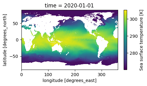
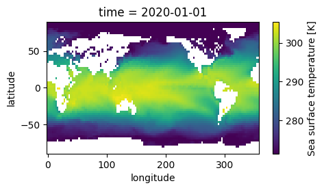
However, we still have missing values (NaN) in the locations shown in white over land. We’ll fill those with values from the nearest non-missing locations:
regridded_and_filled = xarray_utils.fill_nan_with_nearest(regridded)
regridded_and_filled.sea_surface_temperature.plot(x='longitude', y='latitude', aspect=2, size=2.5);
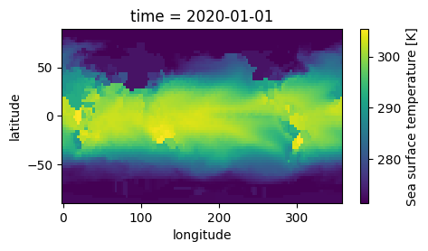
Now we have a dataset ready for feeding into NeuralGCM!
Converting to/from Xarray#
NeuralGCM’s learned methods transform data in the form of dictionaries of torch tensors:
Expected dict keys for
inputsandforcingsare indicated bymodel.input_variablesandmodel.forcing_variables.Dictionary values are tensors with shape
(time, level, longitude, latitude)for pressure-level variables and(time, longitude, latitude)for surface forcings. A leading time axis is always present (length one for a single snapshot).
inputs_from_xarray and forcings_from_xarray convert xarray.Dataset
objects with the appropriate variables into dictionary-of-tensors format
(an optional device= argument overrides the model’s device, e.g. for
data loading on CPU):
inputs = model.inputs_from_xarray(regridded_and_filled)
forcings = model.forcings_from_xarray(regridded_and_filled)
{k: tuple(v.shape) for k, v in inputs.items()}
{'geopotential': (1, 37, 128, 64),
 'specific_humidity': (1, 37, 128, 64),
 'temperature': (1, 37, 128, 64),
 'u_component_of_wind': (1, 37, 128, 64),
 'v_component_of_wind': (1, 37, 128, 64),
 'specific_cloud_ice_water_content': (1, 37, 128, 64),
 'specific_cloud_liquid_water_content': (1, 37, 128, 64),
 'sim_time': (1,)}
{k: tuple(v.shape) for k, v in forcings.items()}
{'sea_ice_cover': (1, 128, 64),
 'sea_surface_temperature': (1, 128, 64),
 'sim_time': (1,)}
Notice that sim_time was calculated automatically. It can also be
calculated explicitly from numpy.datetime64 arrays using
datetime64_to_sim_time:
inputs['sim_time']
tensor([188693.6250], device='cuda:0')
model.datetime64_to_sim_time(np.atleast_1d(regridded_and_filled.time.data))
array([188693.6256])
Outputs from NeuralGCM can be converted back into an xarray.Dataset with
appropriate coordinates via data_to_xarray. Pass times=None if the
arrays have no leading time-axis (e.g. the outputs of decode), or supply
a 1D array of time values matching the leading axis:
model.data_to_xarray(
    model.inputs_from_xarray(regridded_and_filled),
    times=np.atleast_1d(regridded_and_filled.time.data),
)
<xarray.Dataset> Size: 8MB
Dimensions:                              (time: 1, level: 37, longitude: 128,
                                          latitude: 64)
Coordinates:
  * time                                 (time) datetime64[ns] 8B 2020-01-01
  * level                                (level) float64 296B 1.0 2.0 ... 1e+03
  * longitude                            (longitude) float64 1kB 0.0 ... 357.2
  * latitude                             (latitude) float64 512B -87.86 ... 8...
Data variables:
    geopotential                         (time, level, longitude, latitude) float32 1MB ...
    specific_humidity                    (time, level, longitude, latitude) float32 1MB ...
    temperature                          (time, level, longitude, latitude) float32 1MB ...
    u_component_of_wind                  (time, level, longitude, latitude) float32 1MB ...
    v_component_of_wind                  (time, level, longitude, latitude) float32 1MB ...
    specific_cloud_ice_water_content     (time, level, longitude, latitude) float32 1MB ...
specific_cloud_liquid_water_content (time, level, longitude, latitude) float32 1MB ...- time: 1
- level: 37
- longitude: 128
- latitude: 64
- time(time)datetime64[ns]2020-01-01
array(['2020-01-01T00:00:00.000000000'], dtype='datetime64[ns]')
- level(level)float641.0 2.0 3.0 ... 950.0 975.0 1e+03
array([ 1., 2., 3., 5., 7., 10., 20., 30., 50., 70., 100., 125., 150., 175., 200., 225., 250., 300., 350., 400., 450., 500., 550., 600., 650., 700., 750., 775., 800., 825., 850., 875., 900., 925., 950., 975., 1000.]) - longitude(longitude)float640.0 2.812 5.625 ... 354.4 357.2
array([ 0. , 2.8125, 5.625 , 8.4375, 11.25 , 14.0625, 16.875 , 19.6875, 22.5 , 25.3125, 28.125 , 30.9375, 33.75 , 36.5625, 39.375 , 42.1875, 45. , 47.8125, 50.625 , 53.4375, 56.25 , 59.0625, 61.875 , 64.6875, 67.5 , 70.3125, 73.125 , 75.9375, 78.75 , 81.5625, 84.375 , 87.1875, 90. , 92.8125, 95.625 , 98.4375, 101.25 , 104.0625, 106.875 , 109.6875, 112.5 , 115.3125, 118.125 , 120.9375, 123.75 , 126.5625, 129.375 , 132.1875, 135. , 137.8125, 140.625 , 143.4375, 146.25 , 149.0625, 151.875 , 154.6875, 157.5 , 160.3125, 163.125 , 165.9375, 168.75 , 171.5625, 174.375 , 177.1875, 180. , 182.8125, 185.625 , 188.4375, 191.25 , 194.0625, 196.875 , 199.6875, 202.5 , 205.3125, 208.125 , 210.9375, 213.75 , 216.5625, 219.375 , 222.1875, 225. , 227.8125, 230.625 , 233.4375, 236.25 , 239.0625, 241.875 , 244.6875, 247.5 , 250.3125, 253.125 , 255.9375, 258.75 , 261.5625, 264.375 , 267.1875, 270. , 272.8125, 275.625 , 278.4375, 281.25 , 284.0625, 286.875 , 289.6875, 292.5 , 295.3125, 298.125 , 300.9375, 303.75 , 306.5625, 309.375 , 312.1875, 315. , 317.8125, 320.625 , 323.4375, 326.25 , 329.0625, 331.875 , 334.6875, 337.5 , 340.3125, 343.125 , 345.9375, 348.75 , 351.5625, 354.375 , 357.1875]) - latitude(latitude)float64-87.86 -85.1 -82.31 ... 85.1 87.86
array([-87.863799, -85.096527, -82.312913, -79.525607, -76.7369  , -73.947515,
       -71.157752, -68.367756, -65.577607, -62.787352, -59.99702 , -57.206632,
       -54.4162  , -51.625734, -48.835241, -46.044727, -43.254195, -40.463648,
       -37.67309 , -34.882521, -32.091944, -29.30136 , -26.510769, -23.720174,
       -20.929574, -18.138971, -15.348365, -12.557756,  -9.767146,  -6.976534,
        -4.185921,  -1.395307,   1.395307,   4.185921,   6.976534,   9.767146,
        12.557756,  15.348365,  18.138971,  20.929574,  23.720174,  26.510769,
        29.30136 ,  32.091944,  34.882521,  37.67309 ,  40.463648,  43.254195,
        46.044727,  48.835241,  51.625734,  54.4162  ,  57.206632,  59.99702 ,
        62.787352,  65.577607,  68.367756,  71.157752,  73.947515,  76.7369  ,
        79.525607,  82.312913,  85.096527,  87.863799])
- geopotential(time, level, longitude, latitude)float324.931e+05 4.928e+05 ... -72.61
array([[[[ 4.9305122e+05, 4.9281672e+05, 4.9248794e+05, ..., 4.2202688e+05, 4.2354856e+05, 4.2598719e+05], [ 4.9304969e+05, 4.9281319e+05, 4.9246272e+05, ..., 4.2201375e+05, 4.2356700e+05, 4.2597247e+05], [ 4.9304891e+05, 4.9280962e+05, 4.9243991e+05, ..., 4.2200150e+05, 4.2359150e+05, 4.2596381e+05], ..., [ 4.9306044e+05, 4.9282594e+05, 4.9253738e+05, ..., 4.2201688e+05, 4.2354162e+05, 4.2607191e+05], [ 4.9305638e+05, 4.9282272e+05, 4.9252575e+05, ..., 4.2203116e+05, 4.2353306e+05, 4.2603662e+05], [ 4.9305338e+05, 4.9281962e+05, 4.9251003e+05, ..., 4.2203419e+05, 4.2353719e+05, 4.2600844e+05]], [[ 4.3545066e+05, 4.3527400e+05, 4.3502756e+05, ..., 3.7041806e+05, 3.7218566e+05, 3.7458800e+05], [ 4.3544578e+05, 4.3526409e+05, 4.3500556e+05, ..., 3.7032138e+05, 3.7210109e+05, 3.7453675e+05], [ 4.3544122e+05, 4.3525722e+05, 4.3499119e+05, ..., 3.7023656e+05, 3.7202647e+05, 3.7449266e+05], ... 1.5556472e+03, 1.7373971e+03, 1.7505217e+03], [ 1.5358275e+03, 1.4250343e+03, 1.5151041e+03, ..., 1.5018232e+03, 1.7054238e+03, 1.7437126e+03], [ 1.5219178e+03, 1.3993448e+03, 1.4990712e+03, ..., 1.4773099e+03, 1.6830853e+03, 1.7363398e+03]], [[-4.5016650e+02, -5.8576758e+02, -4.4697229e+02, ..., -3.8915100e+02, -1.6458029e+02, -7.9425980e+01], [-4.6841144e+02, -6.0912646e+02, -4.1735757e+02, ..., -3.7578040e+02, -1.7473497e+02, -8.4773262e+01], [-4.8782236e+02, -6.2837610e+02, -3.9926187e+02, ..., -3.6105859e+02, -1.8367313e+02, -8.9416718e+01], ..., [-4.0496228e+02, -5.0315842e+02, -4.1238922e+02, ..., -2.8317902e+02, -8.3439354e+01, -5.6128426e+01], [-4.1924991e+02, -5.3351099e+02, -4.4370312e+02, ..., -3.5293173e+02, -1.2125460e+02, -6.4145584e+01], [-4.3411804e+02, -5.6144153e+02, -4.6169635e+02, ..., -3.8372900e+02, -1.4654565e+02, -7.2613205e+01]]]], shape=(1, 37, 128, 64), dtype=float32) - specific_humidity(time, level, longitude, latitude)float323.952e-06 3.941e-06 ... 0.0004169
array([[[[3.9519564e-06, 3.9407701e-06, 3.9319380e-06, ..., 3.6398685e-06, 3.7301315e-06, 3.7999675e-06], [3.9527104e-06, 3.9412780e-06, 3.9326228e-06, ..., 3.6628430e-06, 3.6964693e-06, 3.7878349e-06], [3.9536312e-06, 3.9418123e-06, 3.9334859e-06, ..., 3.6922229e-06, 3.6669521e-06, 3.7749999e-06], ..., [3.9503711e-06, 3.9400879e-06, 3.9321071e-06, ..., 3.6534695e-06, 3.8553580e-06, 3.8314324e-06], [3.9508254e-06, 3.9401339e-06, 3.9315560e-06, ..., 3.6165627e-06, 3.8099995e-06, 3.8219318e-06], [3.9513766e-06, 3.9403703e-06, 3.9315278e-06, ..., 3.6190486e-06, 3.7682726e-06, 3.8113026e-06]], [[3.7639279e-06, 3.7558107e-06, 3.7438963e-06, ..., 3.4663728e-06, 3.5292542e-06, 3.4962168e-06], [3.7632681e-06, 3.7558070e-06, 3.7431528e-06, ..., 3.4624261e-06, 3.5278515e-06, 3.4975185e-06], [3.7625935e-06, 3.7557986e-06, 3.7421837e-06, ..., 3.4604022e-06, 3.5268783e-06, 3.4983123e-06], ... 6.1180996e-04, 4.6718764e-04, 3.9794843e-04], [4.5445282e-04, 7.4379571e-04, 1.0839116e-03, ..., 7.6615612e-04, 5.2067131e-04, 4.0627224e-04], [4.5124517e-04, 7.7335408e-04, 1.0722927e-03, ..., 8.2662306e-04, 5.4431043e-04, 4.1253457e-04]], [[4.4952153e-04, 8.0081570e-04, 1.0228809e-03, ..., 8.6930604e-04, 5.7046744e-04, 4.1675882e-04], [4.5029988e-04, 8.2115910e-04, 9.6349226e-04, ..., 8.2767342e-04, 5.3951028e-04, 4.2067139e-04], [4.5333002e-04, 8.3688746e-04, 9.0196205e-04, ..., 7.8868627e-04, 4.9214292e-04, 4.1517749e-04], ..., [4.5858035e-04, 7.1049476e-04, 1.0684527e-03, ..., 6.5202353e-04, 5.0345965e-04, 4.1833599e-04], [4.5446857e-04, 7.4378832e-04, 1.0839496e-03, ..., 8.0619199e-04, 5.5137888e-04, 4.1774072e-04], [4.5125626e-04, 7.7340833e-04, 1.0722796e-03, ..., 8.5810293e-04, 5.7512079e-04, 4.1687707e-04]]]], shape=(1, 37, 128, 64), dtype=float32) - temperature(time, level, longitude, latitude)float32288.4 288.0 287.3 ... 252.1 249.3
array([[[[288.36243, 288.0475 , 287.302 , ..., 270.74457, 268.53735, 264.66663], [288.4671 , 288.03537, 287.44412, ..., 270.60114, 268.949 , 264.8736 ], [288.58313, 288.0144 , 287.66556, ..., 270.44177, 269.3163 , 265.0616 ], ..., [288.12637, 288.128 , 287.7759 , ..., 270.60593, 266.98956, 263.97577], [288.19186, 288.08286, 287.4626 , ..., 270.78427, 267.5606 , 264.21396], [288.27045, 288.05923, 287.29593, ..., 270.81836, 268.07635, 264.4452 ]], [[287.55276, 286.25793, 285.99133, ..., 240.59488, 243.14934, 243.74182], [287.4767 , 286.37692, 285.86447, ..., 241.03622, 243.59566, 243.93561], [287.39883, 286.49744, 285.71664, ..., 241.5214 , 244.05225, 244.13057], ... [265.63287, 267.02914, 268.29373, ..., 252.00372, 249.52457, 248.09361], [265.76016, 267.42957, 268.75882, ..., 254.38547, 250.36768, 248.31917], [265.9069 , 267.80713, 269.0691 , ..., 255.6139 , 250.82332, 248.55562]], [[267.35068, 269.4659 , 270.26764, ..., 257.58582, 251.97823, 249.4035 ], [267.53607, 269.8219 , 269.89084, ..., 257.61285, 251.42548, 249.46974], [267.73398, 270.13663, 269.5367 , ..., 257.19717, 250.7079 , 249.41763], ..., [266.91724, 268.32144, 269.59036, ..., 253.3115 , 250.89352, 248.95961], [267.04382, 268.7188 , 270.05716, ..., 255.62645, 251.6979 , 249.10806], [267.1875 , 269.101 , 270.3673 , ..., 256.68204, 252.08286, 249.27045]]]], shape=(1, 37, 128, 64), dtype=float32) - u_component_of_wind(time, level, longitude, latitude)float32-10.71 -14.92 ... -0.5274 2.565
array([[[[-1.07077904e+01, -1.49225178e+01, -1.58517208e+01, ..., -3.12643967e+01, -3.84384918e+01, -5.75683212e+01], [-1.07315702e+01, -1.51179438e+01, -1.54758263e+01, ..., -3.32729263e+01, -3.80188217e+01, -5.75119820e+01], [-1.07347574e+01, -1.53051186e+01, -1.52670488e+01, ..., -3.52321968e+01, -3.76752548e+01, -5.73569298e+01], ..., [-1.04785395e+01, -1.43590927e+01, -1.68928986e+01, ..., -2.69036503e+01, -4.01099472e+01, -5.70525513e+01], [-1.05840359e+01, -1.45580292e+01, -1.67221832e+01, ..., -2.78724041e+01, -3.95043373e+01, -5.73493576e+01], [-1.06596165e+01, -1.47381115e+01, -1.63187618e+01, ..., -2.93885098e+01, -3.89363747e+01, -5.75171967e+01]], [[-4.49280167e+00, -1.69908381e+00, -7.23468351e+00, ..., -3.04546051e+01, -4.38029022e+01, -5.77512817e+01], [-4.73201275e+00, -1.83018517e+00, -7.12605906e+00, ..., -3.01789246e+01, -4.39633904e+01, -5.88081207e+01], [-4.96866751e+00, -2.02444983e+00, -6.95506907e+00, ..., -2.99233608e+01, -4.40043755e+01, -5.97148132e+01], ... 1.18202078e+00, 2.74045765e-01, 4.98265839e+00], [-2.77740860e+00, -4.48989153e-01, 6.73911393e-01, ..., -1.84859002e+00, -4.13927287e-01, 4.43532515e+00], [-2.76203084e+00, -1.67920828e-01, 9.26687241e-01, ..., -4.42918444e+00, -7.73556411e-01, 3.87106967e+00]], [[-2.79848099e+00, 2.50648186e-02, 1.06202674e+00, ..., -4.23742437e+00, -6.71195269e-01, 2.01345778e+00], [-2.86310410e+00, 1.42887428e-01, 1.28367054e+00, ..., -4.21474171e+00, -5.35182476e-01, 1.36141050e+00], [-2.90912914e+00, 3.01484406e-01, 1.62408495e+00, ..., -3.58707237e+00, -2.92502642e-01, 7.14399993e-01], ..., [-2.83278251e+00, -6.94305837e-01, 3.54615152e-01, ..., 1.53967273e+00, 5.59489191e-01, 3.23358107e+00], [-2.77094173e+00, -4.48346078e-01, 6.73928082e-01, ..., -1.16705990e+00, -8.57930928e-02, 2.96003771e+00], [-2.75927448e+00, -1.68895245e-01, 9.26615596e-01, ..., -3.08777261e+00, -5.27416706e-01, 2.56496859e+00]]]], shape=(1, 37, 128, 64), dtype=float32) - v_component_of_wind(time, level, longitude, latitude)float320.5623 3.129 ... -5.072 -1.874
array([[[[ 5.62346578e-01, 3.12903881e+00, 3.28905892e+00, ..., -1.14624810e+00, 6.67946994e-01, -1.00736971e+01], [ 1.19582586e-01, 2.56982613e+00, 3.17612243e+00, ..., -1.21683395e+00, 2.52339005e+00, -7.03560305e+00], [-3.05454671e-01, 1.94999397e+00, 3.10555816e+00, ..., -7.73423314e-01, 4.22844315e+00, -4.06955719e+00], ..., [ 1.91371000e+00, 4.56196594e+00, 3.97494864e+00, ..., 1.36892855e-01, -6.53457451e+00, -1.95740223e+01], [ 1.46666646e+00, 4.10787201e+00, 3.66360426e+00, ..., -1.01277255e-01, -3.76986599e+00, -1.63492165e+01], [ 1.01403737e+00, 3.63483596e+00, 3.44336557e+00, ..., -6.88140154e-01, -1.39982569e+00, -1.31809959e+01]], [[ 4.49206257e+00, 4.86117506e+00, 5.52720976e+00, ..., -1.46003265e+01, -1.97441158e+01, -3.34142380e+01], [ 4.39446354e+00, 5.00816727e+00, 5.15488911e+00, ..., -1.19860172e+01, -1.65069599e+01, -3.00362949e+01], [ 4.28684092e+00, 5.12492085e+00, 5.05068398e+00, ..., -9.46128941e+00, -1.33719254e+01, -2.66608810e+01], ... -9.82058907e+00, -8.87758923e+00, -3.20829487e+00], [ 9.25086141e-01, -3.96286994e-01, -4.26981002e-02, ..., -5.67000246e+00, -7.74450207e+00, -3.47842884e+00], [ 7.77499974e-01, -7.25841582e-01, -1.01253760e+00, ..., -1.84977019e+00, -6.39354372e+00, -3.61866760e+00]], [[ 6.18968248e-01, -9.95379448e-01, -2.26794434e+00, ..., -3.46667498e-01, -4.09912729e+00, -1.85580444e+00], [ 4.72250074e-01, -1.17679286e+00, -2.96933579e+00, ..., 3.48391570e-02, -3.31566334e+00, -1.74537098e+00], [ 3.41865391e-01, -1.31064546e+00, -3.17962599e+00, ..., -1.42753318e-01, -2.86802077e+00, -1.58552182e+00], ..., [ 1.06104779e+00, -1.27451912e-01, 1.88979894e-01, ..., -7.99345446e+00, -6.91052008e+00, -1.57416999e+00], [ 9.27164733e-01, -3.95791352e-01, -4.36872989e-02, ..., -4.94768620e+00, -6.07580805e+00, -1.77718961e+00], [ 7.77246475e-01, -7.26565242e-01, -1.01224864e+00, ..., -2.35039043e+00, -5.07207775e+00, -1.87435055e+00]]]], shape=(1, 37, 128, 64), dtype=float32) - specific_cloud_ice_water_content(time, level, longitude, latitude)float320.0 0.0 0.0 ... 2.692e-06 2.651e-07
array([[[[0.00000000e+00, 0.00000000e+00, 0.00000000e+00, ..., 0.00000000e+00, 0.00000000e+00, 0.00000000e+00], [0.00000000e+00, 0.00000000e+00, 0.00000000e+00, ..., 0.00000000e+00, 0.00000000e+00, 0.00000000e+00], [0.00000000e+00, 0.00000000e+00, 0.00000000e+00, ..., 0.00000000e+00, 0.00000000e+00, 0.00000000e+00], ..., [0.00000000e+00, 0.00000000e+00, 0.00000000e+00, ..., 0.00000000e+00, 0.00000000e+00, 0.00000000e+00], [0.00000000e+00, 0.00000000e+00, 0.00000000e+00, ..., 0.00000000e+00, 0.00000000e+00, 0.00000000e+00], [0.00000000e+00, 0.00000000e+00, 0.00000000e+00, ..., 0.00000000e+00, 0.00000000e+00, 0.00000000e+00]], [[0.00000000e+00, 0.00000000e+00, 0.00000000e+00, ..., 0.00000000e+00, 0.00000000e+00, 0.00000000e+00], [0.00000000e+00, 0.00000000e+00, 0.00000000e+00, ..., 0.00000000e+00, 0.00000000e+00, 0.00000000e+00], [0.00000000e+00, 0.00000000e+00, 0.00000000e+00, ..., 0.00000000e+00, 0.00000000e+00, 0.00000000e+00], ... 1.96963992e-05, 9.50717458e-06, 1.62941078e-07], [0.00000000e+00, 2.28403565e-06, 3.91906997e-06, ..., 1.78835253e-05, 1.01664900e-05, 1.82848666e-07], [2.05420259e-09, 2.82154224e-06, 3.93821483e-06, ..., 1.34554366e-05, 1.44446476e-05, 2.40656817e-07]], [[1.30278828e-08, 3.12924612e-06, 5.27200700e-06, ..., 4.92852996e-06, 4.78328366e-06, 3.12262387e-07], [1.45330539e-08, 2.95026780e-06, 6.60648175e-06, ..., 3.98932207e-06, 5.29267254e-06, 5.87753277e-07], [8.23373298e-08, 3.03301476e-06, 6.10566258e-06, ..., 4.31792660e-06, 6.08941355e-06, 1.53826841e-06], ..., [0.00000000e+00, 1.64557161e-06, 5.64723905e-06, ..., 5.80161941e-06, 5.36721814e-07, 1.95277053e-07], [0.00000000e+00, 2.28411000e-06, 3.91926324e-06, ..., 5.10019754e-06, 9.57592988e-07, 2.31230700e-07], [2.06959294e-09, 2.82154065e-06, 3.93823666e-06, ..., 5.63942558e-06, 2.69214661e-06, 2.65054496e-07]]]], shape=(1, 37, 128, 64), dtype=float32) - specific_cloud_liquid_water_content(time, level, longitude, latitude)float320.0 0.0 0.0 ... 1.323e-06 0.0 0.0
array([[[[0.00000000e+00, 0.00000000e+00, 0.00000000e+00, ...,
          0.00000000e+00, 0.00000000e+00, 0.00000000e+00],
         [0.00000000e+00, 0.00000000e+00, 0.00000000e+00, ...,
          0.00000000e+00, 0.00000000e+00, 0.00000000e+00],
         [0.00000000e+00, 0.00000000e+00, 0.00000000e+00, ...,
          0.00000000e+00, 0.00000000e+00, 0.00000000e+00],
         ...,
         [0.00000000e+00, 0.00000000e+00, 0.00000000e+00, ...,
          0.00000000e+00, 0.00000000e+00, 0.00000000e+00],
         [0.00000000e+00, 0.00000000e+00, 0.00000000e+00, ...,
          0.00000000e+00, 0.00000000e+00, 0.00000000e+00],
         [0.00000000e+00, 0.00000000e+00, 0.00000000e+00, ...,
          0.00000000e+00, 0.00000000e+00, 0.00000000e+00]],

        [[0.00000000e+00, 0.00000000e+00, 0.00000000e+00, ...,
          0.00000000e+00, 0.00000000e+00, 0.00000000e+00],
         [0.00000000e+00, 0.00000000e+00, 0.00000000e+00, ...,
          0.00000000e+00, 0.00000000e+00, 0.00000000e+00],
         [0.00000000e+00, 0.00000000e+00, 0.00000000e+00, ...,
          0.00000000e+00, 0.00000000e+00, 0.00000000e+00],
...
          3.81511640e-08, 2.53736907e-08, 0.00000000e+00],
         [0.00000000e+00, 8.67633446e-07, 1.40318116e-06, ...,
          1.53335679e-06, 2.57092996e-08, 1.29325901e-08],
         [0.00000000e+00, 5.37217375e-07, 3.59365487e-07, ...,
          9.74199793e-06, 2.50846224e-08, 6.79407250e-08]],

        [[0.00000000e+00, 1.77390866e-08, 1.51293289e-09, ...,
          1.18857679e-05, 8.73099850e-08, 0.00000000e+00],
         [0.00000000e+00, 0.00000000e+00, 5.70468650e-08, ...,
          2.30553997e-05, 9.01155147e-07, 1.86256273e-08],
         [0.00000000e+00, 0.00000000e+00, 1.48094550e-08, ...,
          2.79331052e-05, 3.03883553e-06, 2.75438833e-06],
         ...,
         [0.00000000e+00, 4.92782817e-07, 1.53490248e-06, ...,
          9.36440525e-09, 0.00000000e+00, 0.00000000e+00],
         [0.00000000e+00, 8.76975093e-07, 1.40761813e-06, ...,
          1.09223905e-07, 0.00000000e+00, 0.00000000e+00],
         [0.00000000e+00, 5.33313539e-07, 3.64432140e-07, ...,
          1.32272862e-06, 0.00000000e+00, 0.00000000e+00]]]],
      shape=(1, 37, 128, 64), dtype=float32)
In principle, sim_time_to_datetime64 can calculate output times
automatically (e.g., from the outputs of unroll), but this isn’t
recommended. Like JAX, this port does math in float32 mode, which can
result in significant rounding errors (e.g., up to a few minutes). As
illustrated in the forecast_quickstart notebook, we recommend calculating
times directly with NumPy or pandas.
Time shifting#
In the NeuralGCM paper, we used one other data preparation trick for forcing variables: we shifted them backwards in time (by one day), so we could not be accused of leaking data from the future into our weather forecasts.
This can be reproduced with the selective_temporal_shift() utility,
which acts lazily even on datasets that do not fit into memory:
xarray_utils.selective_temporal_shift(
    dataset=full_era5,
    variables=model.forcing_variables,
    time_shift='24 hours',
)
<xarray.Dataset> Size: 4PB
Dimensions:                                                          (
                                                                      time: 1323624,
                                                                      latitude: 721,
                                                                      longitude: 1440,
                                                                      level: 37)
Coordinates:
  * time                                                             (time) datetime64[ns] 11MB ...
  * latitude                                                         (latitude) float32 3kB ...
  * longitude                                                        (longitude) float32 6kB ...
  * level                                                            (level) int64 296B ...
Data variables: (12/273)
    100m_u_component_of_wind                                         (time, latitude, longitude) float32 5TB ...
    100m_v_component_of_wind                                         (time, latitude, longitude) float32 5TB ...
    10m_u_component_of_neutral_wind                                  (time, latitude, longitude) float32 5TB ...
    10m_u_component_of_wind                                          (time, latitude, longitude) float32 5TB ...
    10m_v_component_of_neutral_wind                                  (time, latitude, longitude) float32 5TB ...
    10m_v_component_of_wind                                          (time, latitude, longitude) float32 5TB ...
    ...                                                               ...
    wave_spectral_directional_width_for_swell                        (time, latitude, longitude) float32 5TB ...
    wave_spectral_directional_width_for_wind_waves                   (time, latitude, longitude) float32 5TB ...
    wave_spectral_kurtosis                                           (time, latitude, longitude) float32 5TB ...
    wave_spectral_peakedness                                         (time, latitude, longitude) float32 5TB ...
    wave_spectral_skewness                                           (time, latitude, longitude) float32 5TB ...
    zero_degree_level                                                (time, latitude, longitude) float32 5TB ...
Attributes:
    last_updated:           2026-06-12 02:43:37.240316+00:00
    valid_time_start:       1940-01-01
    valid_time_stop:        2025-12-31
valid_time_stop_era5t: 2026-06-06- time: 1323624
- latitude: 721
- longitude: 1440
- level: 37
- time(time)datetime64[ns]1900-01-02 ... 2050-12-31T23:00:00
array(['1900-01-02T00:00:00.000000000', '1900-01-02T01:00:00.000000000', '1900-01-02T02:00:00.000000000', ..., '2050-12-31T21:00:00.000000000', '2050-12-31T22:00:00.000000000', '2050-12-31T23:00:00.000000000'], shape=(1323624,), dtype='datetime64[ns]') - latitude(latitude)float3290.0 89.75 89.5 ... -89.75 -90.0
- long_name :
- latitude
- units :
- degrees_north
array([ 90. , 89.75, 89.5 , ..., -89.5 , -89.75, -90. ], shape=(721,), dtype=float32) - longitude(longitude)float320.0 0.25 0.5 ... 359.2 359.5 359.8
- long_name :
- longitude
- units :
- degrees_east
array([0.0000e+00, 2.5000e-01, 5.0000e-01, ..., 3.5925e+02, 3.5950e+02, 3.5975e+02], shape=(1440,), dtype=float32) - level(level)int641 2 3 5 7 ... 900 925 950 975 1000
- long_name :
- level
- units :
- Hectopascal(hPa)
array([   1,    2,    3,    5,    7,   10,   20,   30,   50,   70,  100,  125,
        150,  175,  200,  225,  250,  300,  350,  400,  450,  500,  550,  600,
        650,  700,  750,  775,  800,  825,  850,  875,  900,  925,  950,  975,
       1000])
- 100m_u_component_of_wind(time, latitude, longitude)float32...
- long_name :
- 100 metre U wind component
- short_name :
- u100
- units :
- m s**-1
[1374239381760 values with dtype=float32]
- 100m_v_component_of_wind(time, latitude, longitude)float32...
- long_name :
- 100 metre V wind component
- short_name :
- v100
- units :
- m s**-1
[1374239381760 values with dtype=float32]
- 10m_u_component_of_neutral_wind(time, latitude, longitude)float32...
- long_name :
- Neutral wind at 10 m u-component
- short_name :
- u10n
- units :
- m s**-1
[1374239381760 values with dtype=float32]
- 10m_u_component_of_wind(time, latitude, longitude)float32...
- long_name :
- 10 metre U wind component
- short_name :
- u10
- units :
- m s**-1
[1374239381760 values with dtype=float32]
- 10m_v_component_of_neutral_wind(time, latitude, longitude)float32...
- long_name :
- Neutral wind at 10 m v-component
- short_name :
- v10n
- units :
- m s**-1
[1374239381760 values with dtype=float32]
- 10m_v_component_of_wind(time, latitude, longitude)float32...
- long_name :
- 10 metre V wind component
- short_name :
- v10
- units :
- m s**-1
[1374239381760 values with dtype=float32]
- 10m_wind_gust_since_previous_post_processing(time, latitude, longitude)float32...
- long_name :
- 10 metre wind gust since previous post-processing
- short_name :
- fg10
- units :
- m s**-1
[1374239381760 values with dtype=float32]
- 2m_dewpoint_temperature(time, latitude, longitude)float32...
- long_name :
- 2 metre dewpoint temperature
- short_name :
- d2m
- units :
- K
[1374239381760 values with dtype=float32]
- 2m_temperature(time, latitude, longitude)float32...
- long_name :
- 2 metre temperature
- short_name :
- t2m
- units :
- K
[1374239381760 values with dtype=float32]
- air_density_over_the_oceans(time, latitude, longitude)float32...
- long_name :
- Air density over the oceans
- short_name :
- p140209
- units :
- kg m**-3
[1374239381760 values with dtype=float32]
- angle_of_sub_gridscale_orography(time, latitude, longitude)float32...
- long_name :
- Angle of sub-gridscale orography
- short_name :
- anor
- units :
- radians
[1374239381760 values with dtype=float32]
- anisotropy_of_sub_gridscale_orography(time, latitude, longitude)float32...
- long_name :
- Anisotropy of sub-gridscale orography
- short_name :
- isor
- units :
- ~
[1374239381760 values with dtype=float32]
- benjamin_feir_index(time, latitude, longitude)float32...
- long_name :
- Benjamin-Feir index
- short_name :
- bfi
- units :
- dimensionless
[1374239381760 values with dtype=float32]
- boundary_layer_dissipation(time, latitude, longitude)float32...
- long_name :
- Boundary layer dissipation
- short_name :
- bld
- standard_name :
- kinetic_energy_dissipation_in_atmosphere_boundary_layer
- units :
- J m**-2
[1374239381760 values with dtype=float32]
- boundary_layer_height(time, latitude, longitude)float32...
- long_name :
- Boundary layer height
- short_name :
- blh
- units :
- m
[1374239381760 values with dtype=float32]
- charnock(time, latitude, longitude)float32...
- long_name :
- Charnock
- short_name :
- chnk
- units :
- ~
[1374239381760 values with dtype=float32]
- clear_sky_direct_solar_radiation_at_surface(time, latitude, longitude)float32...
- long_name :
- Clear-sky direct solar radiation at surface
- short_name :
- cdir
- units :
- J m**-2
[1374239381760 values with dtype=float32]
- cloud_base_height(time, latitude, longitude)float32...
- long_name :
- Cloud base height
- short_name :
- cbh
- units :
- m
[1374239381760 values with dtype=float32]
- coefficient_of_drag_with_waves(time, latitude, longitude)float32...
- long_name :
- Coefficient of drag with waves
- short_name :
- cdww
- units :
- dimensionless
[1374239381760 values with dtype=float32]
- convective_available_potential_energy(time, latitude, longitude)float32...
- long_name :
- Convective available potential energy
- short_name :
- cape
- units :
- J kg**-1
[1374239381760 values with dtype=float32]
- convective_inhibition(time, latitude, longitude)float32...
- long_name :
- Convective inhibition
- short_name :
- cin
- units :
- J kg**-1
[1374239381760 values with dtype=float32]
- convective_precipitation(time, latitude, longitude)float32...
- long_name :
- Convective precipitation
- short_name :
- cp
- standard_name :
- lwe_thickness_of_convective_precipitation_amount
- units :
- m
[1374239381760 values with dtype=float32]
- convective_rain_rate(time, latitude, longitude)float32...
- long_name :
- Convective rain rate
- short_name :
- crr
- units :
- kg m**-2 s**-1
[1374239381760 values with dtype=float32]
- convective_snowfall(time, latitude, longitude)float32...
- long_name :
- Convective snowfall
- short_name :
- csf
- units :
- m of water equivalent
[1374239381760 values with dtype=float32]
- convective_snowfall_rate_water_equivalent(time, latitude, longitude)float32...
- long_name :
- Convective snowfall rate water equivalent
- short_name :
- csfr
- units :
- kg m**-2 s**-1
[1374239381760 values with dtype=float32]
- downward_uv_radiation_at_the_surface(time, latitude, longitude)float32...
- long_name :
- Downward UV radiation at the surface
- short_name :
- uvb
- units :
- J m**-2
[1374239381760 values with dtype=float32]
- duct_base_height(time, latitude, longitude)float32...
- long_name :
- Duct base height
- short_name :
- dctb
- units :
- m
[1374239381760 values with dtype=float32]
- eastward_gravity_wave_surface_stress(time, latitude, longitude)float32...
- long_name :
- Eastward gravity wave surface stress
- short_name :
- lgws
- units :
- N m**-2 s
[1374239381760 values with dtype=float32]
- eastward_turbulent_surface_stress(time, latitude, longitude)float32...
- long_name :
- Eastward turbulent surface stress
- short_name :
- ewss
- standard_name :
- surface_downward_eastward_stress
- units :
- N m**-2 s
[1374239381760 values with dtype=float32]
- evaporation(time, latitude, longitude)float32...
- long_name :
- Evaporation
- short_name :
- e
- standard_name :
- lwe_thickness_of_water_evaporation_amount
- units :
- m of water equivalent
[1374239381760 values with dtype=float32]
- forecast_albedo(time, latitude, longitude)float32...
- long_name :
- Forecast albedo
- short_name :
- fal
- units :
- (0 - 1)
[1374239381760 values with dtype=float32]
- forecast_logarithm_of_surface_roughness_for_heat(time, latitude, longitude)float32...
- long_name :
- Forecast logarithm of surface roughness for heat
- short_name :
- flsr
- units :
- ~
[1374239381760 values with dtype=float32]
- forecast_surface_roughness(time, latitude, longitude)float32...
- long_name :
- Forecast surface roughness
- short_name :
- fsr
- units :
- m
[1374239381760 values with dtype=float32]
- fraction_of_cloud_cover(time, level, latitude, longitude)float32...
- long_name :
- Fraction of cloud cover
- short_name :
- cc
- units :
- (0 - 1)
[50846857125120 values with dtype=float32]
- free_convective_velocity_over_the_oceans(time, latitude, longitude)float32...
- long_name :
- Free convective velocity over the oceans
- short_name :
- p140208
- units :
- m s**-1
[1374239381760 values with dtype=float32]
- friction_velocity(time, latitude, longitude)float32...
- long_name :
- Friction velocity
- short_name :
- zust
- units :
- m s**-1
[1374239381760 values with dtype=float32]
- geopotential(time, level, latitude, longitude)float32...
- long_name :
- Geopotential
- short_name :
- z
- standard_name :
- geopotential
- units :
- m**2 s**-2
[50846857125120 values with dtype=float32]
- geopotential_at_surface(time, latitude, longitude)float32...
- long_name :
- Geopotential
- short_name :
- z
- standard_name :
- geopotential
- units :
- m**2 s**-2
[1374239381760 values with dtype=float32]
- gravity_wave_dissipation(time, latitude, longitude)float32...
- long_name :
- Gravity wave dissipation
- short_name :
- gwd
- units :
- J m**-2
[1374239381760 values with dtype=float32]
- high_cloud_cover(time, latitude, longitude)float32...
- long_name :
- High cloud cover
- short_name :
- hcc
- units :
- (0 - 1)
[1374239381760 values with dtype=float32]
- high_vegetation_cover(time, latitude, longitude)float32...
- long_name :
- High vegetation cover
- short_name :
- cvh
- units :
- (0 - 1)
[1374239381760 values with dtype=float32]
- ice_temperature_layer_1(time, latitude, longitude)float32...
- long_name :
- Ice temperature layer 1
- short_name :
- istl1
- units :
- K
[1374239381760 values with dtype=float32]
- ice_temperature_layer_2(time, latitude, longitude)float32...
- long_name :
- Ice temperature layer 2
- short_name :
- istl2
- units :
- K
[1374239381760 values with dtype=float32]
- ice_temperature_layer_3(time, latitude, longitude)float32...
- long_name :
- Ice temperature layer 3
- short_name :
- istl3
- units :
- K
[1374239381760 values with dtype=float32]
- ice_temperature_layer_4(time, latitude, longitude)float32...
- long_name :
- Ice temperature layer 4
- short_name :
- istl4
- units :
- K
[1374239381760 values with dtype=float32]
- instantaneous_10m_wind_gust(time, latitude, longitude)float32...
- long_name :
- Instantaneous 10 metre wind gust
- short_name :
- i10fg
- units :
- m s**-1
[1374239381760 values with dtype=float32]
- instantaneous_eastward_turbulent_surface_stress(time, latitude, longitude)float32...
- long_name :
- Instantaneous eastward turbulent surface stress
- short_name :
- iews
- units :
- N m**-2
[1374239381760 values with dtype=float32]
- instantaneous_large_scale_surface_precipitation_fraction(time, latitude, longitude)float32...
- long_name :
- Instantaneous large-scale surface precipitation fraction
- short_name :
- ilspf
- units :
- (0 - 1)
[1374239381760 values with dtype=float32]
- instantaneous_moisture_flux(time, latitude, longitude)float32...
- long_name :
- Instantaneous moisture flux
- short_name :
- ie
- units :
- kg m**-2 s**-1
[1374239381760 values with dtype=float32]
- instantaneous_northward_turbulent_surface_stress(time, latitude, longitude)float32...
- long_name :
- Instantaneous northward turbulent surface stress
- short_name :
- inss
- units :
- N m**-2
[1374239381760 values with dtype=float32]
- instantaneous_surface_sensible_heat_flux(time, latitude, longitude)float32...
- long_name :
- Instantaneous surface sensible heat flux
- short_name :
- ishf
- units :
- W m**-2
[1374239381760 values with dtype=float32]
- k_index(time, latitude, longitude)float32...
- long_name :
- K index
- short_name :
- kx
- units :
- K
[1374239381760 values with dtype=float32]
- lake_bottom_temperature(time, latitude, longitude)float32...
- long_name :
- Lake bottom temperature
- short_name :
- lblt
- units :
- K
[1374239381760 values with dtype=float32]
- lake_cover(time, latitude, longitude)float32...
- long_name :
- Lake cover
- short_name :
- cl
- units :
- (0 - 1)
[1374239381760 values with dtype=float32]
- lake_depth(time, latitude, longitude)float32...
- long_name :
- Lake total depth
- short_name :
- dl
- units :
- m
[1374239381760 values with dtype=float32]
- lake_ice_depth(time, latitude, longitude)float32...
- long_name :
- Lake ice total depth
- short_name :
- licd
- units :
- m
[1374239381760 values with dtype=float32]
- lake_ice_temperature(time, latitude, longitude)float32...
- long_name :
- Lake ice surface temperature
- short_name :
- lict
- units :
- K
[1374239381760 values with dtype=float32]
- lake_mix_layer_depth(time, latitude, longitude)float32...
- long_name :
- Lake mix-layer depth
- short_name :
- lmld
- units :
- m
[1374239381760 values with dtype=float32]
- lake_mix_layer_temperature(time, latitude, longitude)float32...
- long_name :
- Lake mix-layer temperature
- short_name :
- lmlt
- units :
- K
[1374239381760 values with dtype=float32]
- lake_shape_factor(time, latitude, longitude)float32...
- long_name :
- Lake shape factor
- short_name :
- lshf
- units :
- dimensionless
[1374239381760 values with dtype=float32]
- lake_total_layer_temperature(time, latitude, longitude)float32...
- long_name :
- Lake total layer temperature
- short_name :
- ltlt
- units :
- K
[1374239381760 values with dtype=float32]
- land_sea_mask(time, latitude, longitude)float32...
- long_name :
- Land-sea mask
- short_name :
- lsm
- standard_name :
- land_binary_mask
- units :
- (0 - 1)
[1374239381760 values with dtype=float32]
- large_scale_precipitation(time, latitude, longitude)float32...
- long_name :
- Large-scale precipitation
- short_name :
- lsp
- standard_name :
- lwe_thickness_of_stratiform_precipitation_amount
- units :
- m
[1374239381760 values with dtype=float32]
- large_scale_precipitation_fraction(time, latitude, longitude)float32...
- long_name :
- Large-scale precipitation fraction
- short_name :
- lspf
- units :
- s
[1374239381760 values with dtype=float32]
- large_scale_rain_rate(time, latitude, longitude)float32...
- long_name :
- Large scale rain rate
- short_name :
- lsrr
- units :
- kg m**-2 s**-1
[1374239381760 values with dtype=float32]
- large_scale_snowfall(time, latitude, longitude)float32...
- long_name :
- Large-scale snowfall
- short_name :
- lsf
- units :
- m of water equivalent
[1374239381760 values with dtype=float32]
- large_scale_snowfall_rate_water_equivalent(time, latitude, longitude)float32...
- long_name :
- Large scale snowfall rate water equivalent
- short_name :
- lssfr
- units :
- kg m**-2 s**-1
[1374239381760 values with dtype=float32]
- leaf_area_index_high_vegetation(time, latitude, longitude)float32...
- long_name :
- Leaf area index, high vegetation
- short_name :
- lai_hv
- units :
- m**2 m**-2
[1374239381760 values with dtype=float32]
- leaf_area_index_low_vegetation(time, latitude, longitude)float32...
- long_name :
- Leaf area index, low vegetation
- short_name :
- lai_lv
- units :
- m**2 m**-2
[1374239381760 values with dtype=float32]
- low_cloud_cover(time, latitude, longitude)float32...
- long_name :
- Low cloud cover
- short_name :
- lcc
- units :
- (0 - 1)
[1374239381760 values with dtype=float32]
- low_vegetation_cover(time, latitude, longitude)float32...
- long_name :
- Low vegetation cover
- short_name :
- cvl
- units :
- (0 - 1)
[1374239381760 values with dtype=float32]
- maximum_2m_temperature_since_previous_post_processing(time, latitude, longitude)float32...
- long_name :
- Maximum temperature at 2 metres since previous post-processing
- short_name :
- mx2t
- units :
- K
[1374239381760 values with dtype=float32]
- maximum_individual_wave_height(time, latitude, longitude)float32...
- long_name :
- Maximum individual wave height
- short_name :
- hmax
- units :
- m
[1374239381760 values with dtype=float32]
- maximum_total_precipitation_rate_since_previous_post_processing(time, latitude, longitude)float32...
- long_name :
- Maximum total precipitation rate since previous post-processing
- short_name :
- mxtpr
- units :
- kg m**-2 s**-1
[1374239381760 values with dtype=float32]
- mean_boundary_layer_dissipation(time, latitude, longitude)float32...
- long_name :
- Mean boundary layer dissipation
- short_name :
- mbld
- units :
- W m**-2
[1374239381760 values with dtype=float32]
- mean_convective_precipitation_rate(time, latitude, longitude)float32...
- long_name :
- Mean convective precipitation rate
- short_name :
- mcpr
- units :
- kg m**-2 s**-1
[1374239381760 values with dtype=float32]
- mean_convective_snowfall_rate(time, latitude, longitude)float32...
- long_name :
- Mean convective snowfall rate
- short_name :
- mcsr
- units :
- kg m**-2 s**-1
[1374239381760 values with dtype=float32]
- mean_direction_of_total_swell(time, latitude, longitude)float32...
- long_name :
- Mean direction of total swell
- short_name :
- mdts
- units :
- degrees
[1374239381760 values with dtype=float32]
- mean_direction_of_wind_waves(time, latitude, longitude)float32...
- long_name :
- Mean direction of wind waves
- short_name :
- mdww
- units :
- degrees
[1374239381760 values with dtype=float32]
- mean_eastward_gravity_wave_surface_stress(time, latitude, longitude)float32...
- long_name :
- Mean eastward gravity wave surface stress
- short_name :
- megwss
- units :
- N m**-2
[1374239381760 values with dtype=float32]
- mean_eastward_turbulent_surface_stress(time, latitude, longitude)float32...
- long_name :
- Mean eastward turbulent surface stress
- short_name :
- metss
- units :
- N m**-2
[1374239381760 values with dtype=float32]
- mean_evaporation_rate(time, latitude, longitude)float32...
- long_name :
- Mean evaporation rate
- short_name :
- mer
- units :
- kg m**-2 s**-1
[1374239381760 values with dtype=float32]
- mean_gravity_wave_dissipation(time, latitude, longitude)float32...
- long_name :
- Mean gravity wave dissipation
- short_name :
- mgwd
- units :
- W m**-2
[1374239381760 values with dtype=float32]
- mean_large_scale_precipitation_fraction(time, latitude, longitude)float32...
- long_name :
- Mean large-scale precipitation fraction
- short_name :
- mlspf
- units :
- Proportion
[1374239381760 values with dtype=float32]
- mean_large_scale_precipitation_rate(time, latitude, longitude)float32...
- long_name :
- Mean large-scale precipitation rate
- short_name :
- mlspr
- units :
- kg m**-2 s**-1
[1374239381760 values with dtype=float32]
- mean_large_scale_snowfall_rate(time, latitude, longitude)float32...
- long_name :
- Mean large-scale snowfall rate
- short_name :
- mlssr
- units :
- kg m**-2 s**-1
[1374239381760 values with dtype=float32]
- mean_northward_gravity_wave_surface_stress(time, latitude, longitude)float32...
- long_name :
- Mean northward gravity wave surface stress
- short_name :
- mngwss
- units :
- N m**-2
[1374239381760 values with dtype=float32]
- mean_northward_turbulent_surface_stress(time, latitude, longitude)float32...
- long_name :
- Mean northward turbulent surface stress
- short_name :
- mntss
- units :
- N m**-2
[1374239381760 values with dtype=float32]
- mean_period_of_total_swell(time, latitude, longitude)float32...
- long_name :
- Mean period of total swell
- short_name :
- mpts
- units :
- s
[1374239381760 values with dtype=float32]
- mean_period_of_wind_waves(time, latitude, longitude)float32...
- long_name :
- Mean period of wind waves
- short_name :
- mpww
- units :
- s
[1374239381760 values with dtype=float32]
- mean_potential_evaporation_rate(time, latitude, longitude)float32...
- long_name :
- Mean potential evaporation rate
- short_name :
- mper
- units :
- kg m**-2 s**-1
[1374239381760 values with dtype=float32]
- mean_runoff_rate(time, latitude, longitude)float32...
- long_name :
- Mean runoff rate
- short_name :
- mror
- units :
- kg m**-2 s**-1
[1374239381760 values with dtype=float32]
- mean_sea_level_pressure(time, latitude, longitude)float32...
- long_name :
- Mean sea level pressure
- short_name :
- msl
- standard_name :
- air_pressure_at_mean_sea_level
- units :
- Pa
[1374239381760 values with dtype=float32]
- mean_snow_evaporation_rate(time, latitude, longitude)float32...
- long_name :
- Mean snow evaporation rate
- short_name :
- mser
- units :
- kg m**-2 s**-1
[1374239381760 values with dtype=float32]
- mean_snowfall_rate(time, latitude, longitude)float32...
- long_name :
- Mean snowfall rate
- short_name :
- msr
- units :
- kg m**-2 s**-1
[1374239381760 values with dtype=float32]
- mean_snowmelt_rate(time, latitude, longitude)float32...
- long_name :
- Mean snowmelt rate
- short_name :
- msmr
- units :
- kg m**-2 s**-1
[1374239381760 values with dtype=float32]
- mean_square_slope_of_waves(time, latitude, longitude)float32...
- long_name :
- Mean square slope of waves
- short_name :
- msqs
- units :
- dimensionless
[1374239381760 values with dtype=float32]
- mean_sub_surface_runoff_rate(time, latitude, longitude)float32...
- long_name :
- Mean sub-surface runoff rate
- short_name :
- mssror
- units :
- kg m**-2 s**-1
[1374239381760 values with dtype=float32]
- mean_surface_direct_short_wave_radiation_flux(time, latitude, longitude)float32...
- long_name :
- Mean surface direct short-wave radiation flux
- short_name :
- msdrswrf
- units :
- W m**-2
[1374239381760 values with dtype=float32]
- mean_surface_direct_short_wave_radiation_flux_clear_sky(time, latitude, longitude)float32...
- long_name :
- Mean surface direct short-wave radiation flux, clear sky
- short_name :
- msdrswrfcs
- units :
- W m**-2
[1374239381760 values with dtype=float32]
- mean_surface_downward_long_wave_radiation_flux(time, latitude, longitude)float32...
- long_name :
- Mean surface downward long-wave radiation flux
- short_name :
- msdwlwrf
- units :
- W m**-2
[1374239381760 values with dtype=float32]
- mean_surface_downward_long_wave_radiation_flux_clear_sky(time, latitude, longitude)float32...
- long_name :
- Mean surface downward long-wave radiation flux, clear sky
- short_name :
- msdwlwrfcs
- units :
- W m**-2
[1374239381760 values with dtype=float32]
- mean_surface_downward_short_wave_radiation_flux(time, latitude, longitude)float32...
- long_name :
- Mean surface downward short-wave radiation flux
- short_name :
- msdwswrf
- units :
- W m**-2
[1374239381760 values with dtype=float32]
- mean_surface_downward_short_wave_radiation_flux_clear_sky(time, latitude, longitude)float32...
- long_name :
- Mean surface downward short-wave radiation flux, clear sky
- short_name :
- msdwswrfcs
- units :
- W m**-2
[1374239381760 values with dtype=float32]
- mean_surface_downward_uv_radiation_flux(time, latitude, longitude)float32...
- long_name :
- Mean surface downward UV radiation flux
- short_name :
- msdwuvrf
- units :
- W m**-2
[1374239381760 values with dtype=float32]
- mean_surface_latent_heat_flux(time, latitude, longitude)float32...
- long_name :
- Mean surface latent heat flux
- short_name :
- mslhf
- units :
- W m**-2
[1374239381760 values with dtype=float32]
- mean_surface_net_long_wave_radiation_flux(time, latitude, longitude)float32...
- long_name :
- Mean surface net long-wave radiation flux
- short_name :
- msnlwrf
- units :
- W m**-2
[1374239381760 values with dtype=float32]
- mean_surface_net_long_wave_radiation_flux_clear_sky(time, latitude, longitude)float32...
- long_name :
- Mean surface net long-wave radiation flux, clear sky
- short_name :
- msnlwrfcs
- units :
- W m**-2
[1374239381760 values with dtype=float32]
- mean_surface_net_short_wave_radiation_flux(time, latitude, longitude)float32...
- long_name :
- Mean surface net short-wave radiation flux
- short_name :
- msnswrf
- units :
- W m**-2
[1374239381760 values with dtype=float32]
- mean_surface_net_short_wave_radiation_flux_clear_sky(time, latitude, longitude)float32...
- long_name :
- Mean surface net short-wave radiation flux, clear sky
- short_name :
- msnswrfcs
- units :
- W m**-2
[1374239381760 values with dtype=float32]
- mean_surface_runoff_rate(time, latitude, longitude)float32...
- long_name :
- Mean surface runoff rate
- short_name :
- msror
- units :
- kg m**-2 s**-1
[1374239381760 values with dtype=float32]
- mean_surface_sensible_heat_flux(time, latitude, longitude)float32...
- long_name :
- Mean surface sensible heat flux
- short_name :
- msshf
- units :
- W m**-2
[1374239381760 values with dtype=float32]
- mean_top_downward_short_wave_radiation_flux(time, latitude, longitude)float32...
- long_name :
- Mean top downward short-wave radiation flux
- short_name :
- mtdwswrf
- units :
- W m**-2
[1374239381760 values with dtype=float32]
- mean_top_net_long_wave_radiation_flux(time, latitude, longitude)float32...
- long_name :
- Mean top net long-wave radiation flux
- short_name :
- mtnlwrf
- units :
- W m**-2
[1374239381760 values with dtype=float32]
- mean_top_net_long_wave_radiation_flux_clear_sky(time, latitude, longitude)float32...
- long_name :
- Mean top net long-wave radiation flux, clear sky
- short_name :
- mtnlwrfcs
- units :
- W m**-2
[1374239381760 values with dtype=float32]
- mean_top_net_short_wave_radiation_flux(time, latitude, longitude)float32...
- long_name :
- Mean top net short-wave radiation flux
- short_name :
- mtnswrf
- units :
- W m**-2
[1374239381760 values with dtype=float32]
- mean_top_net_short_wave_radiation_flux_clear_sky(time, latitude, longitude)float32...
- long_name :
- Mean top net short-wave radiation flux, clear sky
- short_name :
- mtnswrfcs
- units :
- W m**-2
[1374239381760 values with dtype=float32]
- mean_total_precipitation_rate(time, latitude, longitude)float32...
- long_name :
- Mean total precipitation rate
- short_name :
- mtpr
- units :
- kg m**-2 s**-1
[1374239381760 values with dtype=float32]
- mean_vertical_gradient_of_refractivity_inside_trapping_layer(time, latitude, longitude)float32...
- long_name :
- Mean vertical gradient of refractivity inside trapping layer
- short_name :
- dndza
- units :
- m**-1
[1374239381760 values with dtype=float32]
- mean_vertically_integrated_moisture_divergence(time, latitude, longitude)float32...
- long_name :
- Mean vertically integrated moisture divergence
- short_name :
- mvimd
- units :
- kg m**-2 s**-1
[1374239381760 values with dtype=float32]
- mean_wave_direction(time, latitude, longitude)float32...
- long_name :
- Mean wave direction
- short_name :
- mwd
- units :
- Degree true
[1374239381760 values with dtype=float32]
- mean_wave_direction_of_first_swell_partition(time, latitude, longitude)float32...
- long_name :
- Mean wave direction of first swell partition
- short_name :
- p140122
- units :
- degrees
[1374239381760 values with dtype=float32]
- mean_wave_direction_of_second_swell_partition(time, latitude, longitude)float32...
- long_name :
- Mean wave direction of second swell partition
- short_name :
- p140125
- units :
- degrees
[1374239381760 values with dtype=float32]
- mean_wave_direction_of_third_swell_partition(time, latitude, longitude)float32...
- long_name :
- Mean wave direction of third swell partition
- short_name :
- p140128
- units :
- degrees
[1374239381760 values with dtype=float32]
- mean_wave_period(time, latitude, longitude)float32...
- long_name :
- Mean wave period
- short_name :
- mwp
- units :
- s
[1374239381760 values with dtype=float32]
- mean_wave_period_based_on_first_moment(time, latitude, longitude)float32...
- long_name :
- Mean wave period based on first moment
- short_name :
- mp1
- units :
- s
[1374239381760 values with dtype=float32]
- mean_wave_period_based_on_first_moment_for_swell(time, latitude, longitude)float32...
- long_name :
- Mean wave period based on first moment for swell
- short_name :
- p1ps
- units :
- s
[1374239381760 values with dtype=float32]
- mean_wave_period_based_on_first_moment_for_wind_waves(time, latitude, longitude)float32...
- long_name :
- Mean wave period based on first moment for wind waves
- short_name :
- p1ww
- units :
- s
[1374239381760 values with dtype=float32]
- mean_wave_period_based_on_second_moment_for_swell(time, latitude, longitude)float32...
- long_name :
- Mean wave period based on second moment for swell
- short_name :
- p2ps
- units :
- s
[1374239381760 values with dtype=float32]
- mean_wave_period_based_on_second_moment_for_wind_waves(time, latitude, longitude)float32...
- long_name :
- Mean wave period based on second moment for wind waves
- short_name :
- p2ww
- units :
- s
[1374239381760 values with dtype=float32]
- mean_wave_period_of_first_swell_partition(time, latitude, longitude)float32...
- long_name :
- Mean wave period of first swell partition
- short_name :
- p140123
- units :
- s
[1374239381760 values with dtype=float32]
- mean_wave_period_of_second_swell_partition(time, latitude, longitude)float32...
- long_name :
- Mean wave period of second swell partition
- short_name :
- p140126
- units :
- s
[1374239381760 values with dtype=float32]
- mean_wave_period_of_third_swell_partition(time, latitude, longitude)float32...
- long_name :
- Mean wave period of third swell partition
- short_name :
- p140129
- units :
- s
[1374239381760 values with dtype=float32]
- mean_zero_crossing_wave_period(time, latitude, longitude)float32...
- long_name :
- Mean zero-crossing wave period
- short_name :
- mp2
- units :
- s
[1374239381760 values with dtype=float32]
- medium_cloud_cover(time, latitude, longitude)float32...
- long_name :
- Medium cloud cover
- short_name :
- mcc
- units :
- (0 - 1)
[1374239381760 values with dtype=float32]
- minimum_2m_temperature_since_previous_post_processing(time, latitude, longitude)float32...
- long_name :
- Minimum temperature at 2 metres since previous post-processing
- short_name :
- mn2t
- units :
- K
[1374239381760 values with dtype=float32]
- minimum_total_precipitation_rate_since_previous_post_processing(time, latitude, longitude)float32...
- long_name :
- Minimum total precipitation rate since previous post-processing
- short_name :
- mntpr
- units :
- kg m**-2 s**-1
[1374239381760 values with dtype=float32]
- minimum_vertical_gradient_of_refractivity_inside_trapping_layer(time, latitude, longitude)float32...
- long_name :
- Minimum vertical gradient of refractivity inside trapping layer
- short_name :
- dndzn
- units :
- m**-1
[1374239381760 values with dtype=float32]
- model_bathymetry(time, latitude, longitude)float32...
- long_name :
- Model bathymetry
- short_name :
- wmb
- units :
- m
[1374239381760 values with dtype=float32]
- near_ir_albedo_for_diffuse_radiation(time, latitude, longitude)float32...
- long_name :
- Near IR albedo for diffuse radiation
- short_name :
- alnid
- units :
- (0 - 1)
[1374239381760 values with dtype=float32]
- near_ir_albedo_for_direct_radiation(time, latitude, longitude)float32...
- long_name :
- Near IR albedo for direct radiation
- short_name :
- alnip
- units :
- (0 - 1)
[1374239381760 values with dtype=float32]
- normalized_energy_flux_into_ocean(time, latitude, longitude)float32...
- long_name :
- Normalized energy flux into ocean
- short_name :
- phioc
- units :
- dimensionless
[1374239381760 values with dtype=float32]
- normalized_energy_flux_into_waves(time, latitude, longitude)float32...
- long_name :
- Normalized energy flux into waves
- short_name :
- phiaw
- units :
- dimensionless
[1374239381760 values with dtype=float32]
- normalized_stress_into_ocean(time, latitude, longitude)float32...
- long_name :
- Normalized stress into ocean
- short_name :
- tauoc
- units :
- dimensionless
[1374239381760 values with dtype=float32]
- northward_gravity_wave_surface_stress(time, latitude, longitude)float32...
- long_name :
- Northward gravity wave surface stress
- short_name :
- mgws
- units :
- N m**-2 s
[1374239381760 values with dtype=float32]
- northward_turbulent_surface_stress(time, latitude, longitude)float32...
- long_name :
- Northward turbulent surface stress
- short_name :
- nsss
- standard_name :
- surface_downward_northward_stress
- units :
- N m**-2 s
[1374239381760 values with dtype=float32]
- ocean_surface_stress_equivalent_10m_neutral_wind_direction(time, latitude, longitude)float32...
- long_name :
- 10 metre wind direction
- short_name :
- dwi
- units :
- degrees
[1374239381760 values with dtype=float32]
- ocean_surface_stress_equivalent_10m_neutral_wind_speed(time, latitude, longitude)float32...
- long_name :
- 10 metre wind speed
- short_name :
- wind
- units :
- m s**-1
[1374239381760 values with dtype=float32]
- ozone_mass_mixing_ratio(time, level, latitude, longitude)float32...
- long_name :
- Ozone mass mixing ratio
- short_name :
- o3
- standard_name :
- mass_fraction_of_ozone_in_air
- units :
- kg kg**-1
[50846857125120 values with dtype=float32]
- peak_wave_period(time, latitude, longitude)float32...
- long_name :
- Peak wave period
- short_name :
- pp1d
- units :
- s
[1374239381760 values with dtype=float32]
- period_corresponding_to_maximum_individual_wave_height(time, latitude, longitude)float32...
- long_name :
- Period corresponding to maximum individual wave height
- short_name :
- tmax
- units :
- s
[1374239381760 values with dtype=float32]
- potential_evaporation(time, latitude, longitude)float32...
- long_name :
- Potential evaporation
- short_name :
- pev
- units :
- m
[1374239381760 values with dtype=float32]
- potential_vorticity(time, level, latitude, longitude)float32...
- long_name :
- Potential vorticity
- short_name :
- pv
- units :
- K m**2 kg**-1 s**-1
[50846857125120 values with dtype=float32]
- precipitation_type(time, latitude, longitude)float32...
- long_name :
- Precipitation type
- short_name :
- ptype
- units :
- code table (4.201)
[1374239381760 values with dtype=float32]
- runoff(time, latitude, longitude)float32...
- long_name :
- Runoff
- short_name :
- ro
- units :
- m
[1374239381760 values with dtype=float32]
- sea_ice_cover(time, latitude, longitude)float32...
- long_name :
- Sea ice area fraction
- short_name :
- siconc
- standard_name :
- sea_ice_area_fraction
- units :
- (0 - 1)
[1374239381760 values with dtype=float32]
- sea_surface_temperature(time, latitude, longitude)float32...
- long_name :
- Sea surface temperature
- short_name :
- sst
- units :
- K
[1374239381760 values with dtype=float32]
- significant_height_of_combined_wind_waves_and_swell(time, latitude, longitude)float32...
- long_name :
- Significant height of combined wind waves and swell
- short_name :
- swh
- units :
- m
[1374239381760 values with dtype=float32]
- significant_height_of_total_swell(time, latitude, longitude)float32...
- long_name :
- Significant height of total swell
- short_name :
- shts
- units :
- m
[1374239381760 values with dtype=float32]
- significant_height_of_wind_waves(time, latitude, longitude)float32...
- long_name :
- Significant height of wind waves
- short_name :
- shww
- units :
- m
[1374239381760 values with dtype=float32]
- significant_wave_height_of_first_swell_partition(time, latitude, longitude)float32...
- long_name :
- Significant wave height of first swell partition
- short_name :
- p140121
- units :
- m
[1374239381760 values with dtype=float32]
- significant_wave_height_of_second_swell_partition(time, latitude, longitude)float32...
- long_name :
- Significant wave height of second swell partition
- short_name :
- p140124
- units :
- m
[1374239381760 values with dtype=float32]
- significant_wave_height_of_third_swell_partition(time, latitude, longitude)float32...
- long_name :
- Significant wave height of third swell partition
- short_name :
- p140127
- units :
- m
[1374239381760 values with dtype=float32]
- skin_reservoir_content(time, latitude, longitude)float32...
- long_name :
- Skin reservoir content
- short_name :
- src
- units :
- m of water equivalent
[1374239381760 values with dtype=float32]
- skin_temperature(time, latitude, longitude)float32...
- long_name :
- Skin temperature
- short_name :
- skt
- units :
- K
[1374239381760 values with dtype=float32]
- slope_of_sub_gridscale_orography(time, latitude, longitude)float32...
- long_name :
- Slope of sub-gridscale orography
- short_name :
- slor
- units :
- ~
[1374239381760 values with dtype=float32]
- snow_albedo(time, latitude, longitude)float32...
- long_name :
- Snow albedo
- short_name :
- asn
- units :
- (0 - 1)
[1374239381760 values with dtype=float32]
- snow_density(time, latitude, longitude)float32...
- long_name :
- Snow density
- short_name :
- rsn
- units :
- kg m**-3
[1374239381760 values with dtype=float32]
- snow_depth(time, latitude, longitude)float32...
- long_name :
- Snow depth
- short_name :
- sd
- standard_name :
- lwe_thickness_of_surface_snow_amount
- units :
- m of water equivalent
[1374239381760 values with dtype=float32]
- snow_evaporation(time, latitude, longitude)float32...
- long_name :
- Snow evaporation
- short_name :
- es
- units :
- m of water equivalent
[1374239381760 values with dtype=float32]
- snowfall(time, latitude, longitude)float32...
- long_name :
- Snowfall
- short_name :
- sf
- standard_name :
- lwe_thickness_of_snowfall_amount
- units :
- m of water equivalent
[1374239381760 values with dtype=float32]
- snowmelt(time, latitude, longitude)float32...
- long_name :
- Snowmelt
- short_name :
- smlt
- units :
- m of water equivalent
[1374239381760 values with dtype=float32]
- soil_temperature_level_1(time, latitude, longitude)float32...
- long_name :
- Soil temperature level 1
- short_name :
- stl1
- standard_name :
- surface_temperature
- units :
- K
[1374239381760 values with dtype=float32]
- soil_temperature_level_2(time, latitude, longitude)float32...
- long_name :
- Soil temperature level 2
- short_name :
- stl2
- units :
- K
[1374239381760 values with dtype=float32]
- soil_temperature_level_3(time, latitude, longitude)float32...
- long_name :
- Soil temperature level 3
- short_name :
- stl3
- units :
- K
[1374239381760 values with dtype=float32]
- soil_temperature_level_4(time, latitude, longitude)float32...
- long_name :
- Soil temperature level 4
- short_name :
- stl4
- units :
- K
[1374239381760 values with dtype=float32]
- soil_type(time, latitude, longitude)float32...
- long_name :
- Soil type
- short_name :
- slt
- units :
- ~
[1374239381760 values with dtype=float32]
- specific_cloud_ice_water_content(time, level, latitude, longitude)float32...
- long_name :
- Specific cloud ice water content
- short_name :
- ciwc
- units :
- kg kg**-1
[50846857125120 values with dtype=float32]
- specific_cloud_liquid_water_content(time, level, latitude, longitude)float32...
- long_name :
- Specific cloud liquid water content
- short_name :
- clwc
- units :
- kg kg**-1
[50846857125120 values with dtype=float32]
- specific_humidity(time, level, latitude, longitude)float32...
- long_name :
- Specific humidity
- short_name :
- q
- standard_name :
- specific_humidity
- units :
- kg kg**-1
[50846857125120 values with dtype=float32]
- standard_deviation_of_filtered_subgrid_orography(time, latitude, longitude)float32...
- long_name :
- Standard deviation of filtered subgrid orography
- short_name :
- sdfor
- units :
- m
[1374239381760 values with dtype=float32]
- standard_deviation_of_orography(time, latitude, longitude)float32...
- long_name :
- Standard deviation of orography
- short_name :
- sdor
- units :
- m
[1374239381760 values with dtype=float32]
- sub_surface_runoff(time, latitude, longitude)float32...
- long_name :
- Sub-surface runoff
- short_name :
- ssro
- units :
- m
[1374239381760 values with dtype=float32]
- surface_latent_heat_flux(time, latitude, longitude)float32...
- long_name :
- Surface latent heat flux
- short_name :
- slhf
- standard_name :
- surface_upward_latent_heat_flux
- units :
- J m**-2
[1374239381760 values with dtype=float32]
- surface_net_solar_radiation(time, latitude, longitude)float32...
- long_name :
- Surface net solar radiation
- short_name :
- ssr
- standard_name :
- surface_net_downward_shortwave_flux
- units :
- J m**-2
[1374239381760 values with dtype=float32]
- surface_net_solar_radiation_clear_sky(time, latitude, longitude)float32...
- long_name :
- Surface net solar radiation, clear sky
- short_name :
- ssrc
- standard_name :
- surface_net_downward_shortwave_flux_assuming_clear_sky
- units :
- J m**-2
[1374239381760 values with dtype=float32]
- surface_net_thermal_radiation(time, latitude, longitude)float32...
- long_name :
- Surface net thermal radiation
- short_name :
- str
- standard_name :
- surface_net_upward_longwave_flux
- units :
- J m**-2
[1374239381760 values with dtype=float32]
- surface_net_thermal_radiation_clear_sky(time, latitude, longitude)float32...
- long_name :
- Surface net thermal radiation, clear sky
- short_name :
- strc
- standard_name :
- surface_net_downward_longwave_flux_assuming_clear_sky
- units :
- J m**-2
[1374239381760 values with dtype=float32]
- surface_pressure(time, latitude, longitude)float32...
- long_name :
- Surface pressure
- short_name :
- sp
- standard_name :
- surface_air_pressure
- units :
- Pa
[1374239381760 values with dtype=float32]
- surface_runoff(time, latitude, longitude)float32...
- long_name :
- Surface runoff
- short_name :
- sro
- units :
- m
[1374239381760 values with dtype=float32]
- surface_sensible_heat_flux(time, latitude, longitude)float32...
- long_name :
- Surface sensible heat flux
- short_name :
- sshf
- standard_name :
- surface_upward_sensible_heat_flux
- units :
- J m**-2
[1374239381760 values with dtype=float32]
- surface_solar_radiation_downward_clear_sky(time, latitude, longitude)float32...
- long_name :
- Surface solar radiation downward clear-sky
- short_name :
- ssrdc
- units :
- J m**-2
[1374239381760 values with dtype=float32]
- surface_solar_radiation_downwards(time, latitude, longitude)float32...
- long_name :
- Surface solar radiation downwards
- short_name :
- ssrd
- standard_name :
- surface_downwelling_shortwave_flux_in_air
- units :
- J m**-2
[1374239381760 values with dtype=float32]
- surface_thermal_radiation_downward_clear_sky(time, latitude, longitude)float32...
- long_name :
- Surface thermal radiation downward clear-sky
- short_name :
- strdc
- units :
- J m**-2
[1374239381760 values with dtype=float32]
- surface_thermal_radiation_downwards(time, latitude, longitude)float32...
- long_name :
- Surface thermal radiation downwards
- short_name :
- strd
- units :
- J m**-2
[1374239381760 values with dtype=float32]
- temperature(time, level, latitude, longitude)float32...
- long_name :
- Temperature
- short_name :
- t
- standard_name :
- air_temperature
- units :
- K
[50846857125120 values with dtype=float32]
- temperature_of_snow_layer(time, latitude, longitude)float32...
- long_name :
- Temperature of snow layer
- short_name :
- tsn
- standard_name :
- temperature_in_surface_snow
- units :
- K
[1374239381760 values with dtype=float32]
- toa_incident_solar_radiation(time, latitude, longitude)float32...
- long_name :
- TOA incident solar radiation
- short_name :
- tisr
- units :
- J m**-2
[1374239381760 values with dtype=float32]
- top_net_solar_radiation(time, latitude, longitude)float32...
- long_name :
- Top net solar radiation
- short_name :
- tsr
- standard_name :
- toa_net_upward_shortwave_flux
- units :
- J m**-2
[1374239381760 values with dtype=float32]
- top_net_solar_radiation_clear_sky(time, latitude, longitude)float32...
- long_name :
- Top net solar radiation, clear sky
- short_name :
- tsrc
- units :
- J m**-2
[1374239381760 values with dtype=float32]
- top_net_thermal_radiation(time, latitude, longitude)float32...
- long_name :
- Top net thermal radiation
- short_name :
- ttr
- standard_name :
- toa_outgoing_longwave_flux
- units :
- J m**-2
[1374239381760 values with dtype=float32]
- top_net_thermal_radiation_clear_sky(time, latitude, longitude)float32...
- long_name :
- Top net thermal radiation, clear sky
- short_name :
- ttrc
- units :
- J m**-2
[1374239381760 values with dtype=float32]
- total_cloud_cover(time, latitude, longitude)float32...
- long_name :
- Total cloud cover
- short_name :
- tcc
- standard_name :
- cloud_area_fraction
- units :
- (0 - 1)
[1374239381760 values with dtype=float32]
- total_column_cloud_ice_water(time, latitude, longitude)float32...
- long_name :
- Total column cloud ice water
- short_name :
- tciw
- units :
- kg m**-2
[1374239381760 values with dtype=float32]
- total_column_cloud_liquid_water(time, latitude, longitude)float32...
- long_name :
- Total column cloud liquid water
- short_name :
- tclw
- units :
- kg m**-2
[1374239381760 values with dtype=float32]
- total_column_ozone(time, latitude, longitude)float32...
- long_name :
- Total column ozone
- short_name :
- tco3
- standard_name :
- atmosphere_mass_content_of_ozone
- units :
- kg m**-2
[1374239381760 values with dtype=float32]
- total_column_rain_water(time, latitude, longitude)float32...
- long_name :
- Total column rain water
- short_name :
- tcrw
- units :
- kg m**-2
[1374239381760 values with dtype=float32]
- total_column_snow_water(time, latitude, longitude)float32...
- long_name :
- Total column snow water
- short_name :
- tcsw
- units :
- kg m**-2
[1374239381760 values with dtype=float32]
- total_column_supercooled_liquid_water(time, latitude, longitude)float32...
- long_name :
- Total column supercooled liquid water
- short_name :
- tcslw
- units :
- kg m**-2
[1374239381760 values with dtype=float32]
- total_column_water(time, latitude, longitude)float32...
- long_name :
- Total column water
- short_name :
- tcw
- units :
- kg m**-2
[1374239381760 values with dtype=float32]
- total_column_water_vapour(time, latitude, longitude)float32...
- long_name :
- Total column vertically-integrated water vapour
- short_name :
- tcwv
- standard_name :
- lwe_thickness_of_atmosphere_mass_content_of_water_vapor
- units :
- kg m**-2
[1374239381760 values with dtype=float32]
- total_precipitation(time, latitude, longitude)float32...
- long_name :
- Total precipitation
- short_name :
- tp
- units :
- m
[1374239381760 values with dtype=float32]
- total_sky_direct_solar_radiation_at_surface(time, latitude, longitude)float32...
- long_name :
- Total sky direct solar radiation at surface
- short_name :
- fdir
- units :
- J m**-2
[1374239381760 values with dtype=float32]
- total_totals_index(time, latitude, longitude)float32...
- long_name :
- Total totals index
- short_name :
- totalx
- units :
- K
[1374239381760 values with dtype=float32]
- trapping_layer_base_height(time, latitude, longitude)float32...
- long_name :
- Trapping layer base height
- short_name :
- tplb
- units :
- m
[1374239381760 values with dtype=float32]
- trapping_layer_top_height(time, latitude, longitude)float32...
- long_name :
- Trapping layer top height
- short_name :
- tplt
- units :
- m
[1374239381760 values with dtype=float32]
- type_of_high_vegetation(time, latitude, longitude)float32...
- long_name :
- Type of high vegetation
- short_name :
- tvh
- units :
- ~
[1374239381760 values with dtype=float32]
- type_of_low_vegetation(time, latitude, longitude)float32...
- long_name :
- Type of low vegetation
- short_name :
- tvl
- units :
- ~
[1374239381760 values with dtype=float32]
- u_component_of_wind(time, level, latitude, longitude)float32...
- long_name :
- U component of wind
- short_name :
- u
- standard_name :
- eastward_wind
- units :
- m s**-1
[50846857125120 values with dtype=float32]
- u_component_stokes_drift(time, latitude, longitude)float32...
- long_name :
- U-component stokes drift
- short_name :
- ust
- units :
- m s**-1
[1374239381760 values with dtype=float32]
- uv_visible_albedo_for_diffuse_radiation(time, latitude, longitude)float32...
- long_name :
- UV visible albedo for diffuse radiation
- short_name :
- aluvd
- units :
- (0 - 1)
[1374239381760 values with dtype=float32]
- uv_visible_albedo_for_direct_radiation(time, latitude, longitude)float32...
- long_name :
- UV visible albedo for direct radiation
- short_name :
- aluvp
- units :
- (0 - 1)
[1374239381760 values with dtype=float32]
- v_component_of_wind(time, level, latitude, longitude)float32...
- long_name :
- V component of wind
- short_name :
- v
- standard_name :
- northward_wind
- units :
- m s**-1
[50846857125120 values with dtype=float32]
- v_component_stokes_drift(time, latitude, longitude)float32...
- long_name :
- V-component stokes drift
- short_name :
- vst
- units :
- m s**-1
[1374239381760 values with dtype=float32]
- vertical_integral_of_divergence_of_cloud_frozen_water_flux(time, latitude, longitude)float32...
- long_name :
- Vertical integral of divergence of cloud frozen water flux
- short_name :
- p80.162
- units :
- kg m**-2 s**-1
[1374239381760 values with dtype=float32]
- vertical_integral_of_divergence_of_cloud_liquid_water_flux(time, latitude, longitude)float32...
- long_name :
- Vertical integral of divergence of cloud liquid water flux
- short_name :
- p79.162
- units :
- kg m**-2 s**-1
[1374239381760 values with dtype=float32]
- vertical_integral_of_divergence_of_geopotential_flux(time, latitude, longitude)float32...
- long_name :
- Vertical integral of divergence of geopotential flux
- short_name :
- p85.162
- units :
- W m**-2
[1374239381760 values with dtype=float32]
- vertical_integral_of_divergence_of_kinetic_energy_flux(time, latitude, longitude)float32...
- long_name :
- Vertical integral of divergence of kinetic energy flux
- short_name :
- p82.162
- units :
- W m**-2
[1374239381760 values with dtype=float32]
- vertical_integral_of_divergence_of_mass_flux(time, latitude, longitude)float32...
- long_name :
- Vertical integral of divergence of mass flux
- short_name :
- p81.162
- units :
- kg m**-2 s**-1
[1374239381760 values with dtype=float32]
- vertical_integral_of_divergence_of_moisture_flux(time, latitude, longitude)float32...
- long_name :
- Vertical integral of divergence of moisture flux
- short_name :
- p84.162
- units :
- kg m**-2 s**-1
[1374239381760 values with dtype=float32]
- vertical_integral_of_divergence_of_ozone_flux(time, latitude, longitude)float32...
- long_name :
- Vertical integral of divergence of ozone flux
- short_name :
- p87.162
- units :
- kg m**-2 s**-1
[1374239381760 values with dtype=float32]
- vertical_integral_of_divergence_of_thermal_energy_flux(time, latitude, longitude)float32...
- long_name :
- Vertical integral of divergence of thermal energy flux
- short_name :
- p83.162
- units :
- W m**-2
[1374239381760 values with dtype=float32]
- vertical_integral_of_divergence_of_total_energy_flux(time, latitude, longitude)float32...
- long_name :
- Vertical integral of divergence of total energy flux
- short_name :
- p86.162
- units :
- W m**-2
[1374239381760 values with dtype=float32]
- vertical_integral_of_eastward_cloud_frozen_water_flux(time, latitude, longitude)float32...
- long_name :
- Vertical integral of eastward cloud frozen water flux
- short_name :
- p90.162
- units :
- kg m**-1 s**-1
[1374239381760 values with dtype=float32]
- vertical_integral_of_eastward_cloud_liquid_water_flux(time, latitude, longitude)float32...
- long_name :
- Vertical integral of eastward cloud liquid water flux
- short_name :
- p88.162
- units :
- kg m**-1 s**-1
[1374239381760 values with dtype=float32]
- vertical_integral_of_eastward_geopotential_flux(time, latitude, longitude)float32...
- long_name :
- Vertical integral of eastward geopotential flux
- short_name :
- p73.162
- units :
- W m**-1
[1374239381760 values with dtype=float32]
- vertical_integral_of_eastward_heat_flux(time, latitude, longitude)float32...
- long_name :
- Vertical integral of eastward heat flux
- short_name :
- p69.162
- units :
- W m**-1
[1374239381760 values with dtype=float32]
- vertical_integral_of_eastward_kinetic_energy_flux(time, latitude, longitude)float32...
- long_name :
- Vertical integral of eastward kinetic energy flux
- short_name :
- p67.162
- units :
- W m**-1
[1374239381760 values with dtype=float32]
- vertical_integral_of_eastward_mass_flux(time, latitude, longitude)float32...
- long_name :
- Vertical integral of eastward mass flux
- short_name :
- p65.162
- units :
- kg m**-1 s**-1
[1374239381760 values with dtype=float32]
- vertical_integral_of_eastward_ozone_flux(time, latitude, longitude)float32...
- long_name :
- Vertical integral of eastward ozone flux
- short_name :
- p77.162
- units :
- kg m**-1 s**-1
[1374239381760 values with dtype=float32]
- vertical_integral_of_eastward_total_energy_flux(time, latitude, longitude)float32...
- long_name :
- Vertical integral of eastward total energy flux
- short_name :
- p75.162
- units :
- W m**-1
[1374239381760 values with dtype=float32]
- vertical_integral_of_eastward_water_vapour_flux(time, latitude, longitude)float32...
- long_name :
- Vertical integral of eastward water vapour flux
- short_name :
- p71.162
- units :
- kg m**-1 s**-1
[1374239381760 values with dtype=float32]
- vertical_integral_of_energy_conversion(time, latitude, longitude)float32...
- long_name :
- Vertical integral of energy conversion
- short_name :
- p64.162
- units :
- W m**-2
[1374239381760 values with dtype=float32]
- vertical_integral_of_kinetic_energy(time, latitude, longitude)float32...
- long_name :
- Vertical integral of kinetic energy
- short_name :
- p59.162
- units :
- J m**-2
[1374239381760 values with dtype=float32]
- vertical_integral_of_mass_of_atmosphere(time, latitude, longitude)float32...
- long_name :
- Vertical integral of mass of atmosphere
- short_name :
- p53.162
- units :
- kg m**-2
[1374239381760 values with dtype=float32]
- vertical_integral_of_mass_tendency(time, latitude, longitude)float32...
- long_name :
- Vertical integral of mass tendency
- short_name :
- p92.162
- units :
- kg m**-2 s**-1
[1374239381760 values with dtype=float32]
- vertical_integral_of_northward_cloud_frozen_water_flux(time, latitude, longitude)float32...
- long_name :
- Vertical integral of northward cloud frozen water flux
- short_name :
- p91.162
- units :
- kg m**-1 s**-1
[1374239381760 values with dtype=float32]
- vertical_integral_of_northward_cloud_liquid_water_flux(time, latitude, longitude)float32...
- long_name :
- Vertical integral of northward cloud liquid water flux
- short_name :
- p89.162
- units :
- kg m**-1 s**-1
[1374239381760 values with dtype=float32]
- vertical_integral_of_northward_geopotential_flux(time, latitude, longitude)float32...
- long_name :
- Vertical integral of northward geopotential flux
- short_name :
- p74.162
- units :
- W m**-1
[1374239381760 values with dtype=float32]
- vertical_integral_of_northward_heat_flux(time, latitude, longitude)float32...
- long_name :
- Vertical integral of northward heat flux
- short_name :
- p70.162
- units :
- W m**-1
[1374239381760 values with dtype=float32]
- vertical_integral_of_northward_kinetic_energy_flux(time, latitude, longitude)float32...
- long_name :
- Vertical integral of northward kinetic energy flux
- short_name :
- p68.162
- units :
- W m**-1
[1374239381760 values with dtype=float32]
- vertical_integral_of_northward_mass_flux(time, latitude, longitude)float32...
- long_name :
- Vertical integral of northward mass flux
- short_name :
- p66.162
- units :
- kg m**-1 s**-1
[1374239381760 values with dtype=float32]
- vertical_integral_of_northward_ozone_flux(time, latitude, longitude)float32...
- long_name :
- Vertical integral of northward ozone flux
- short_name :
- p78.162
- units :
- kg m**-1 s**-1
[1374239381760 values with dtype=float32]
- vertical_integral_of_northward_total_energy_flux(time, latitude, longitude)float32...
- long_name :
- Vertical integral of northward total energy flux
- short_name :
- p76.162
- units :
- W m**-1
[1374239381760 values with dtype=float32]
- vertical_integral_of_northward_water_vapour_flux(time, latitude, longitude)float32...
- long_name :
- Vertical integral of northward water vapour flux
- short_name :
- p72.162
- units :
- kg m**-1 s**-1
[1374239381760 values with dtype=float32]
- vertical_integral_of_potential_and_internal_energy(time, latitude, longitude)float32...
- long_name :
- Vertical integral of potential+internal energy
- short_name :
- p61.162
- units :
- J m**-2
[1374239381760 values with dtype=float32]
- vertical_integral_of_potential_internal_and_latent_energy(time, latitude, longitude)float32...
- long_name :
- Vertical integral of potential+internal+latent energy
- short_name :
- p62.162
- units :
- J m**-2
[1374239381760 values with dtype=float32]
- vertical_integral_of_temperature(time, latitude, longitude)float32...
- long_name :
- Vertical integral of temperature
- short_name :
- p54.162
- units :
- K kg m**-2
[1374239381760 values with dtype=float32]
- vertical_integral_of_thermal_energy(time, latitude, longitude)float32...
- long_name :
- Vertical integral of thermal energy
- short_name :
- p60.162
- units :
- J m**-2
[1374239381760 values with dtype=float32]
- vertical_integral_of_total_energy(time, latitude, longitude)float32...
- long_name :
- Vertical integral of total energy
- short_name :
- p63.162
- units :
- J m**-2
[1374239381760 values with dtype=float32]
- vertical_velocity(time, level, latitude, longitude)float32...
- long_name :
- Vertical velocity
- short_name :
- w
- standard_name :
- lagrangian_tendency_of_air_pressure
- units :
- Pa s**-1
[50846857125120 values with dtype=float32]
- vertically_integrated_moisture_divergence(time, latitude, longitude)float32...
- long_name :
- Vertically integrated moisture divergence
- short_name :
- vimd
- units :
- kg m**-2
[1374239381760 values with dtype=float32]
- volumetric_soil_water_layer_1(time, latitude, longitude)float32...
- long_name :
- Volumetric soil water layer 1
- short_name :
- swvl1
- units :
- m**3 m**-3
[1374239381760 values with dtype=float32]
- volumetric_soil_water_layer_2(time, latitude, longitude)float32...
- long_name :
- Volumetric soil water layer 2
- short_name :
- swvl2
- units :
- m**3 m**-3
[1374239381760 values with dtype=float32]
- volumetric_soil_water_layer_3(time, latitude, longitude)float32...
- long_name :
- Volumetric soil water layer 3
- short_name :
- swvl3
- units :
- m**3 m**-3
[1374239381760 values with dtype=float32]
- volumetric_soil_water_layer_4(time, latitude, longitude)float32...
- long_name :
- Volumetric soil water layer 4
- short_name :
- swvl4
- units :
- m**3 m**-3
[1374239381760 values with dtype=float32]
- wave_spectral_directional_width(time, latitude, longitude)float32...
- long_name :
- Wave spectral directional width
- short_name :
- wdw
- units :
- radians
[1374239381760 values with dtype=float32]
- wave_spectral_directional_width_for_swell(time, latitude, longitude)float32...
- long_name :
- Wave spectral directional width for swell
- short_name :
- dwps
- units :
- radians
[1374239381760 values with dtype=float32]
- wave_spectral_directional_width_for_wind_waves(time, latitude, longitude)float32...
- long_name :
- Wave spectral directional width for wind waves
- short_name :
- dwww
- units :
- radians
[1374239381760 values with dtype=float32]
- wave_spectral_kurtosis(time, latitude, longitude)float32...
- long_name :
- Wave spectral kurtosis
- short_name :
- wsk
- units :
- dimensionless
[1374239381760 values with dtype=float32]
- wave_spectral_peakedness(time, latitude, longitude)float32...
- long_name :
- Wave spectral peakedness
- short_name :
- wsp
- units :
- dimensionless
[1374239381760 values with dtype=float32]
- wave_spectral_skewness(time, latitude, longitude)float32...
- long_name :
- Wave Spectral Skewness
- short_name :
- wss
- units :
- dimensionless
[1374239381760 values with dtype=float32]
- zero_degree_level(time, latitude, longitude)float32...
- long_name :
- 0 degrees C isothermal level (atm)
- short_name :
- deg0l
- units :
- m
[1374239381760 values with dtype=float32]
- last_updated :
- 2026-06-12 02:43:37.240316+00:00
- valid_time_start :
- 1940-01-01
- valid_time_stop :
- 2025-12-31
- valid_time_stop_era5t :
- 2026-06-06